Ability to mantain deep convection is still a problem.
ATL: Tropical Depression Dolly
Moderator: S2k Moderators
Re: 94L..........8 AM TWO=Tropical Cyclone could form anytime
cycloneye wrote::uarrow: That is more north than the other one that Thunder posted.
That's the circulation that the NHC has been tracking since last night.
0 likes
- HURAKAN
- Professional-Met
- Posts: 46086
- Age: 38
- Joined: Thu May 20, 2004 4:34 pm
- Location: Key West, FL
- Contact:
Re:
KWT wrote:Hurakan what is that by the way?
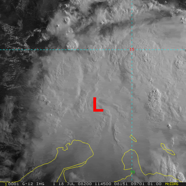
Suggest this does have a closed low but north around 13.5 north.
ROCK, yep recon today is going to be very interesting to watch I feel!
http://rammb.cira.colostate.edu/product ... r=AL942008
Don't know how accurate it's.
0 likes
- srainhoutx
- S2K Supporter
- Posts: 6919
- Age: 67
- Joined: Sun Jan 14, 2007 11:34 am
- Location: Haywood County, NC
- Contact:
Re: ATL: INVEST 94L in Central Caribbean
Good morning. Looks like we may have at least a TD today when RECON arrives a bit later this morning. I see Code Red is back up on NHC/TPC as well. Now HGX and BRO are mentioning this disturbance. Keeping an eye on TUTT over S Bahamas/E Cuba...
http://www.srh.noaa.gov/tropical/satpix ... v_loop.php
0 likes
Re: ATL: INVEST 94L in Central Caribbean
Well, I leave for Cancun area in a few hours. It looks like this thing is going to end up forming. I'll be checking a couple times a day while I'm out there, to be aware of what is going on.
Here's to hoping that if this thing does form and hit the Cancun area, it stays a tropical depression or tropical storm.
0 likes
Re: ATL: INVEST 94L in Central Caribbean
It should have a better chance today, getting into a tad less fast Easterly flow, increasing convergence and decreasing shear.
My bet, a vortex message today from recon, and may skip straight to Cristobal. The offshore Georgia system, if it gets an airplane today, may be TD #4 or Dolly. May do that without an airplane if we get a ship report there. The Navy towers on the NDBC website in the area of 96L all seem out of commission. I think 96L is as close to a lock as possible, with the caveat it stays offshore, and as noted on the 96L thread, a new center may be forming a little further offshore.
All of this very unofficial, of course.
I will also say, unofficially, the 6Z GFDL track towards SW Louisiana seems wrong to me. I prefer the global models. I still think a Yucatan hit, followed by a second landfall, probably in Mexico but possibly close enough to bring seas & squalls South of CRP, seems most likely. This is starting to finally organize a bit too far South and West, on a generally Westward heading, to come as far North as the GFDL implies. But, if I lived in Corpus Christi or Brownsville or America's favorite city, Kingsville, where I once dated a Texas A&I co-ed I met while visiting a friend in Alice, I'd be buying water and batteries and gasoline, things that will get used eventually anyway, but I would not panic.
Even professionals have a hard time with intensity. I'd guess, however, as is its usual bias, the Canadian global is too strong. The UK Met tropical, which never sees this as a storm, may be too weak.
Again, while I think my advice to people living along and inland of South Padre Island is good advice, I suspect they will be at the Northern edge of the inclement weather, and, my advice is unofficial, I'm decent, as an amateur, in my not that humble opinion, but I am still an amateur (to wit - 3 days ago, I thought 94L would be crossing Cuba on its way to Florida), and Storm2K does not endorse this advice in any way.
0 likes
Re:
HURAKAN wrote:Could the ULL in the Bahamas be enhancing the outflow and convection of 94L?
I mentioned that last night, that I thought that the ULL was going to initially give a break to 94L, we will see how they interact over the next couple days, but it is certainly changing the UL winds over 94L.
0 likes
Re: ATL: INVEST 94L in Central Caribbean
Ed Mahmoud wrote:It should have a better chance today, getting into a tad less fast Easterly flow, increasing convergence and decreasing shear.
My bet, a vortex message today from recon, and may skip straight to Cristobal. The offshore Georgia system, if it gets an airplane today, may be TD #4 or Dolly. May do that without an airplane if we get a ship report there. The Navy towers on the NDBC website in the area of 96L all seem out of commission. I think 96L is as close to a lock as possible, with the caveat it stays offshore, and as noted on the 96L thread, a new center may be forming a little further offshore.
All of this very unofficial, of course.
I will also say, unofficially, the 6Z GFDL track towards SW Louisiana seems wrong to me. I prefer the global models. I still think a Yucatan hit, followed by a second landfall, probably in Mexico but possibly close enough to bring seas & squalls South of CRP, seems most likely. This is starting to finally organize a bit too far South and West, on a generally Westward heading, to come as far North as the GFDL implies. But, if I lived in Corpus Christi or Brownsville or America's favorite city, Kingsville, where I once dated a Texas A&I co-ed I met while visiting a friend in Alice, I'd be buying water and batteries and gasoline, things that will get used eventually anyway, but I would not panic.
Even professionals have a hard time with intensity. I'd guess, however, as is its usual bias, the Canadian global is too strong. The UK Met tropical, which never sees this as a storm, may be too weak.
Again, while I think my advice to people living along and inland of South Padre Island is good advice, I suspect they will be at the Northern edge of the inclement weather, and, my advice is unofficial, I'm decent, as an amateur, in my not that humble opinion, but I am still an amateur (to wit - 3 days ago, I thought 94L would be crossing Cuba on its way to Florida), and Storm2K does not endorse this advice in any way.
I can't really read the models....what sort of intensity are the models predicting for the Yucatan hit?
0 likes
Re: ATL: INVEST 94L in Central Caribbean
txag2005 wrote:Well, I leave for Cancun area in a few hours. It looks like this thing is going to end up forming. I'll be checking a couple times a day while I'm out there, to be aware of what is going on.
Here's to hoping that if this thing does form and hit the Cancun area, it stays a tropical depression or tropical storm.
The hotels are well built in Cancun/Cozumel, most survived Wilma pretty well. From what I've seen on TV and read in magazines, many hotels in the Caribbean have a 'safe' area in case a big storm does hit, that doesn't have windows and is well built.
Bring a digital camera, and if you see any palm trees swaying, before it gets too windy to safely stay outdoors, take pics and upload them for our edification when you return.
Have fun. Oh, while ceviche is supposedly 'cooked' in citrus and vinegar, my parents ruined their Acapulco vacation about 20 years ago eating it from a street vendor.
About a day of bad weather, and cool stories for your friends, and then a nice beach vacation, is my unofficial forecast.
0 likes
- srainhoutx
- S2K Supporter
- Posts: 6919
- Age: 67
- Joined: Sun Jan 14, 2007 11:34 am
- Location: Haywood County, NC
- Contact:
Re: Re:
NDG wrote:HURAKAN wrote:Could the ULL in the Bahamas be enhancing the outflow and convection of 94L?
I mentioned that last night, that I thought that the ULL was going to initially give a break to 94L, we will see how they interact over the next couple days, but it is certainly changing the UL winds over 94L.
We are on the same page NDG. As I saw the TUTT last evening getting into the action. RECON should be very interesting today. Ed, you very well be right concerning a VDM from RECON. It won't be much longer until we know the true story concerning 94L. RECON is scheduled to depart around 10:45 EDT from St Croix.
0 likes
-
- S2K Supporter
- Posts: 2776
- Joined: Fri Aug 29, 2003 10:52 am
- Location: Biloxi Beach, Ms
- Contact:
Re: ATL: INVEST 94L in Central Caribbean
Satellite presentation of 94L gets better by the hour... convection also on the rise in the east and north quads... this system is really getting that look with banding effects on the northern half developing as I type this...
0 likes
- HouTXmetro
- Category 5
- Posts: 3949
- Joined: Sun Jun 13, 2004 6:00 pm
- Location: District of Columbia, USA
Well the thing is Ed we were getting flight level winds of 34-35kts in the deep convection yesterday so if this really has strengthened and does have a closed low you may well be right.
Then again its going to be a case of waiting for recon to get a good look at this system. Prehaps the best this system has looked ever today...
0 likes
Who is online
Users browsing this forum: No registered users and 5 guests