ATL: Tropical Depression Dolly
Moderator: S2k Moderators


Re: ATL: TS Dolly in Western Caribbean
IF you take a look at this:
http://cimss.ssec.wisc.edu/tropic/real- ... 8conv.html
and this...
http://cimss.ssec.wisc.edu/tropic/real- ... g8dvg.html
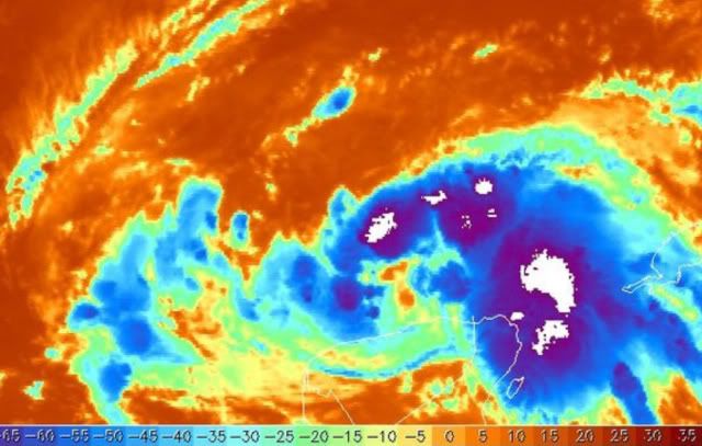
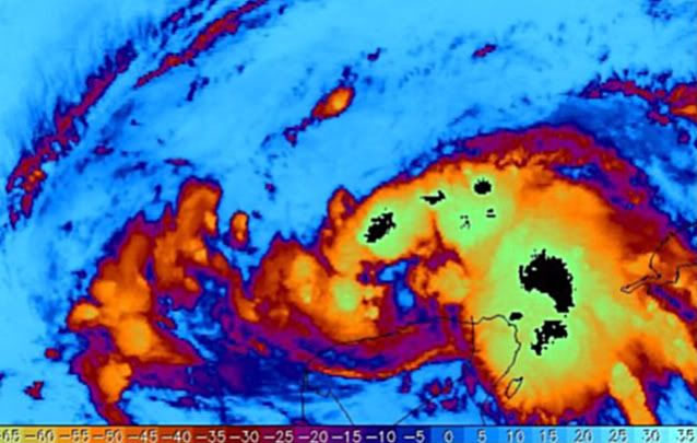
Youll notice that the greatest areas of upper level divergence and lower level convergence are practically stacked on top of each other, which is very conducive for explosive convection (And is the reason why you continually see these convective outbursts over the Yucatan Channel. If you also look at IR you will notice that Dolly's center is WELL west of this area and racing westward (Really has been paralleling the coast per Cancun Radar for the past couple of hours. I mean I hate to use the "R" word again............ No I wont. Dolly is very disorganized right now.
http://cimss.ssec.wisc.edu/tropic/real- ... 8conv.html
and this...
http://cimss.ssec.wisc.edu/tropic/real- ... g8dvg.html
Youll notice that the greatest areas of upper level divergence and lower level convergence are practically stacked on top of each other, which is very conducive for explosive convection (And is the reason why you continually see these convective outbursts over the Yucatan Channel. If you also look at IR you will notice that Dolly's center is WELL west of this area and racing westward (Really has been paralleling the coast per Cancun Radar for the past couple of hours. I mean I hate to use the "R" word again............ No I wont. Dolly is very disorganized right now.
0 likes
-
cycloneye

- Admin

- Posts: 149312
- Age: 69
- Joined: Thu Oct 10, 2002 10:54 am
- Location: San Juan, Puerto Rico
Re: ATL: TS Dolly in Western Caribbean
It looks like its in the water in this nighttime visible.

0 likes
-
Matt-hurricanewatcher
Re: ATL: TS Dolly in Western Caribbean
Derek, Wxman57 or some one else have you ever seen a tropical wave produce 50 knot one minute winds? I know that some tropcial waves can produce 35-40 knots, but this would be a very strong wave.
0 likes
-
Portastorm

- Storm2k Moderator

- Posts: 9955
- Age: 63
- Joined: Fri Jul 11, 2003 9:16 am
- Location: Round Rock, TX
- Contact:
Re: ATL: TS Dolly in Western Caribbean
Interesting comments by NHC in the early morning update. Seems to suggest:
1) Center will reform further north
2) Potential in Gulf for RI
3) Potential for changes in projected landfall
... as someone posted, a lot more questions than answers right now. Gonna be a long week for us!
1) Center will reform further north
2) Potential in Gulf for RI
3) Potential for changes in projected landfall
... as someone posted, a lot more questions than answers right now. Gonna be a long week for us!
0 likes
-
HURAKAN

- Professional-Met

- Posts: 46084
- Age: 39
- Joined: Thu May 20, 2004 4:34 pm
- Location: Key West, FL
- Contact:
110330 2151N 08819W 9554 00455 0063 +225 +207 164020 021 999 999 03
110400 2151N 08821W 9550 00458 0062 +223 +209 171016 017 006 001 03
110430 2151N 08823W 9550 00457 0060 +225 +209 178012 013 999 999 03
110500 2151N 08825W 9551 00455 0060 +222 +210 184009 010 999 999 03
110530 2151N 08827W 9553 00454 0061 +217 +212 152005 006 999 999 03
110600 2151N 08829W 9548 00460 0063 +215 +212 108005 006 003 000 03
1006 mb
0 likes
-
Ed Mahmoud
Re: ATL: TS Dolly in Western Caribbean
Golf forecast for South Texas
AREA FORECAST DISCUSSION
NATIONAL WEATHER SERVICE BROWNSVILLE TX
250 AM CDT MON JUL 21 2008
.
.DISCUSSION...THE POORLY-DEFINED CENTER OF TROPICAL STORM DOLLY WAS
ESTIMATED TO BE NEAR LATITUDE 21.1 NORTH...LONGITUDE 86.8 WEST OR
VERY NEAR CANCUN MEXICO AT 1 AM CDT. RECENT SATELLITE IR IMAGES SHOW
THE CENTER OF DOLLY MOVING OVER THE YUCATAN NEAR MERIDA. LATEST
TROPICAL MODEL ENSEMBLES FROM THE NHC REMAIN VERY CONSISTENT IN
BRINGING T.S. DOLLY AT OR NEAR THE RIO GRANDE VALLEY. ALTHOUGH GFS
SOLUTION FROM 00Z SHOWS DOLLY HALTING JUST 60 NM SOUTHEAST OF
POR...THEN MOVING DIRECTLY SOUTH AND MOVING INLAND THURSDAY MORNING
AT 10 AM ABOUT 237 MILES SOUTH OF POR...NEAR LA PESCA, MEXICO...FEEL
THIS SCENARIO IS HIGHLY UNLIKELY. EXPECT THE INFLUENCE OF DOLLY`S
WINDS ENCROACHING THE GULF WATERS OF THE LOWER TEXAS COAST BY LATE
TUESDAY AFTERNOON...WITH SHRAS/TSRAS MVG ONSHORE LATE TUESDAY. TODAY
AND EARLY TUESDAY MAY BE THE ONLY GOLF DAYS LEFT FOR A WHILE. NEXT
NEW DATA ON DOLLY FROM THE TROPICAL PREDICTION CENTER WILL BE AT 4
AM CDT TODAY.
&&
.
.
.MARINE...AT 2AM BUOY020 REPORTED SOUTH WINDS AT 10KTS AND SEAS 2
FEET. CONDITIONS WILL SLOWLY DETERIORATE ACROSS THE COASTAL WATERS
STARTING IN ABOUT 24 HOURS AS TROPICAL STORM DOLLY APPROACHES. WINDS
AND SEAS WILL BEGIN TO INCREASE TUESDAY MORNING...REACHING SCA
CRITERIA TUESDAY AFTERNOON. SEAS WILL INCREASE TO 5 TO 6 FEET AT
THAT TIME. NHC CONTINUES TO ISSUE ADVISORIES ON DOLLY...WITH THE
CORE CONDITIONS AFFECTING THE COASTAL WATERS FROM LATE TUESDAY
THROUGH EARLY THURSDAY. CURRENT FORECAST FROM THE NHC IS FOR THE TS
TO MAKE LANDFALL LATE WEDNESDAY NIGHT NEAR BROWNSVILLE...WITH WINDS
OF 65 TO 75KTS WITH HIGHER GUSTS. PLEASE STAY TUNED TO THE LATEST
STATEMENTS FROM THE NATIONAL HURRICANE CENTER.
&&
.
.AVIATION...VFR CONDITIONS EXPECTED THROUGH THE NEXT 24 HOURS WITH
MOSTLY CLEAR SKIES AND MODERATE SOUTHERLY WINDS.
&&
.
.
.PRELIMINARY POINT TEMPS/POPS...
BAYVIEW/PORT ISABEL 93 78 87 79 / 0 0 50 50
BROWNSVILLE 96 75 89 76 / 0 0 50 50
HARLINGEN 98 75 88 77 / 0 0 50 50
MCALLEN 99 76 94 76 / 0 0 40 40
RIO GRANDE CITY 103 75 98 77 / 0 0 20 20
SOUTH PADRE ISLAND 91 79 85 78 / 0 10 50 50
0 likes


Re: ATL: TS Dolly in Western Caribbean
Portastorm wrote:Interesting comments by NHC in the early morning update. Seems to suggest:
1) Center will reform further north
2) Potential in Gulf for RI
3) Potential for changes in projected landfall
... as someone posted, a lot more questions than answers right now. Gonna be a long week for us!
Portastorm i got the impression after reading this mornings discussion.
0 likes
-
Portastorm
- Storm2k Moderator
- Posts: 9955
- Age: 63
- Joined: Fri Jul 11, 2003 9:16 am
- Location: Round Rock, TX
- Contact:
Re:
dwg71 wrote:nhc and models have had northern mexico/extreme south texas for some time now. Its not rocket science. only questions are will a llc form and will it intesify rapidly once clear of yuc pen.
I don't disagree with that but when the NHC forecasters write that their guidance shows "different latitudes of landfall" and they keep stressing that people should not focus on the exact landfall point 2-3 days away ... that tells me that they are not all that confident at this moment in the eventual predicted landfall point.
0 likes
-
paintplaye
- Category 1

- Posts: 380
- Joined: Sun Jul 20, 2008 11:25 pm
Re: ATL: TS Dolly in Western Caribbean
Well i wake up and lest see... well the storm looks farther west and north than they though. Still the eventual landfall is even farther SOUTH! I wonder if they really thing the ridge will be this strong especially when they have this thing hitting 12 hours later than originally planed.
0 likes
-
HURAKAN
- Professional-Met
- Posts: 46084
- Age: 39
- Joined: Thu May 20, 2004 4:34 pm
- Location: Key West, FL
- Contact:
114330 2157N 08831W 9557 00453 0064 +220 +211 175018 019 999 999 03
114400 2157N 08833W 9554 00453 0060 +225 +210 189014 015 999 999 03
114430 2157N 08835W 9555 00452 0060 +219 +212 192010 012 999 999 03
114500 2157N 08837W 9551 00455 0061 +219 +213 173006 007 999 999 03
114530 2158N 08839W 9552 00457 0063 +219 +213 118005 006 999 999 03
114600 2158N 08841W 9555 00455 0064 +218 +215 092008 009 004 000 03
Again, 1006 mb.
0 likes

-
srainhoutx

- S2K Supporter

- Posts: 6919
- Age: 68
- Joined: Sun Jan 14, 2007 11:34 am
- Location: Haywood County, NC
- Contact:
Re: ATL: TS Dolly in Western Caribbean
Looking like we still have a mid level system this morning. Still see no indications from RECON of surface LLC at this time.
0 likes
-
HouTXmetro

- Category 5

- Posts: 3949
- Joined: Sun Jun 13, 2004 6:00 pm
- Location: District of Columbia, USA
Re: ATL: TS Dolly in Western Caribbean
Thankfully this storm has struggled to get her act together.
0 likes
Who is online
Users browsing this forum: No registered users and 24 guests