Well Defined Wave off African Coast
Moderator: S2k Moderators
Forum rules

The posts in this forum are NOT official forecasts and should not be used as such. They are just the opinion of the poster and may or may not be backed by sound meteorological data. They are NOT endorsed by any professional institution or STORM2K. For official information, please refer to products from the National Hurricane Center and National Weather Service.
-
HURAKAN

- Professional-Met

- Posts: 46084
- Age: 39
- Joined: Thu May 20, 2004 4:34 pm
- Location: Key West, FL
- Contact:
Re: Organized Wave emerging Africa / Low Pressure still inland
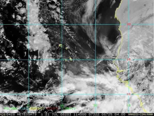
11:45 UTC
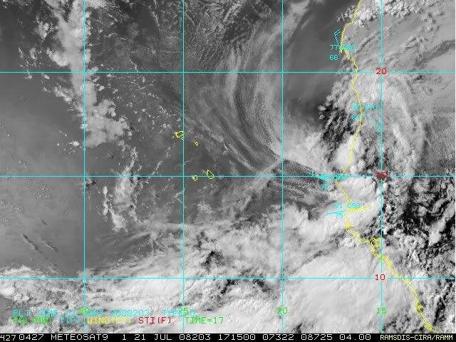
17:15 UTC
Increasing in convection while a West wind is measured in the coast indicating a LLC.
17:15 UTC
Increasing in convection while a West wind is measured in the coast indicating a LLC.
0 likes
-
cycloneye

- Admin

- Posts: 149278
- Age: 69
- Joined: Thu Oct 10, 2002 10:54 am
- Location: San Juan, Puerto Rico
Re: Organized Wave emerging Africa / Low Pressure still inland
984
ABNT20 KNHC 211758
TWOAT
TROPICAL WEATHER OUTLOOK
NWS TPC/NATIONAL HURRICANE CENTER MIAMI FL
200 PM EDT MON JUL 21 2008
FOR THE NORTH ATLANTIC...CARIBBEAN SEA AND THE GULF OF MEXICO...
THE NATIONAL HURRICANE CENTER IS ISSUING ADVISORIES ON TROPICAL
STORM CRISTOBAL...CENTERED ABOUT 190 MILES EAST-NORTHEAST OF CAPE
HATTERAS NORTH CAROLINA...AND ON TROPICAL STORM DOLLY...LOCATED
ABOUT 135 MILES NORTH-NORTHWEST OF PROGRESO MEXICO.
A LARGE AND WELL-DEFINED TROPICAL WAVE IS LOCATED JUST INLAND OVER
EXTREME WESTERN AFRICA. THIS SYSTEM HAS THE POTENTIAL FOR SOME
DEVELOPMENT DURING THE NEXT COUPLE OF DAYS AFTER IT EMERGES INTO THE
TROPICAL EASTERN ATLANTIC OCEAN.
ELSEWHERE...TROPICAL CYCLONE FORMATION IS NOT EXPECTED DURING THE
NEXT 48 HOURS.
$$
FORECASTER BLAKE
0 likes

-
Blown Away

- S2K Supporter

- Posts: 10253
- Joined: Wed May 26, 2004 6:17 am
Re: Organized Wave emerging Africa / Low Pressure still inland
Is the low around 15N/10W?
http://www.ssd.noaa.gov/PS/TROP/DATA/RT ... -loop.html
http://www.ssd.noaa.gov/PS/TROP/DATA/RT ... -loop.html
0 likes

Re: Organized Wave emerges Africa / Low now in the water
I can not believe they are talking about a wave/low that is still over the land. First time I have seen this talked about in such detail prior to it actually emerging. There are so many azazing looking lows/waves that come off the Coast and go poof... This will prove to be an interesting year.
0 likes

-
CrazyC83
- Professional-Met
- Posts: 34315
- Joined: Tue Mar 07, 2006 11:57 pm
- Location: Deep South, for the first time!
Re: Organized Wave emerges Africa
Mecklenburg wrote:why is it not an invest yet?
Should be 97L soon.
0 likes
-
Cryomaniac
- Category 5

- Posts: 1289
- Joined: Tue Aug 15, 2006 2:26 pm
- Location: Newark, Nottinghamshire, UK
- Contact:
Re: Organized Wave emerges Africa
CrazyC83 wrote:Should be 97L soon.
When is this likely to be?
0 likes
-
HURAKAN
- Professional-Met
- Posts: 46084
- Age: 39
- Joined: Thu May 20, 2004 4:34 pm
- Location: Key West, FL
- Contact:
Re: Organized Wave emerges Africa
Cryomaniac wrote:CrazyC83 wrote:Should be 97L soon.
When is this likely to be?
Tonight - tomorrow morning
0 likes
-
Matt-hurricanewatcher
Re: Organized Wave emerging Africa / Low Pressure still inland
HURAKAN wrote:11:45 UTC
17:15 UTC
Increasing in convection while a West wind is measured in the coast indicating a LLC.
If it has a LLC then it should be a depression right off the coast. I'm not even going to hold back because of Dolly not having a LLC for that time. It will be a DEPRESSION PEOPLE IF IT HAS A LLC.
0 likes

Re: Organized Wave emerges Africa
Will this move in the same manor as Bertha and recurve or move further west and threaten the NE islands.Thats me question.
0 likes
-
HURAKAN
- Professional-Met
- Posts: 46084
- Age: 39
- Joined: Thu May 20, 2004 4:34 pm
- Location: Key West, FL
- Contact:
Re: Organized Wave emerges Africa
boca wrote:Will this move in the same manor as Bertha and recurve or move further west and threaten the NE islands.Thats me question.
Will the Rays hold until October? Very difficult to say at this point!!!
0 likes
-
cycloneye
- Admin
- Posts: 149278
- Age: 69
- Joined: Thu Oct 10, 2002 10:54 am
- Location: San Juan, Puerto Rico
Re: Organized Wave emerges Africa
A little less bullish:
229
ABNT20 KNHC 212313
TWOAT
TROPICAL WEATHER OUTLOOK
NWS TPC/NATIONAL HURRICANE CENTER MIAMI FL
800 PM EDT MON JUL 21 2008
FOR THE NORTH ATLANTIC...CARIBBEAN SEA AND THE GULF OF MEXICO...
THE NATIONAL HURRICANE CENTER IS ISSUING ADVISORIES ON TROPICAL
STORM CRISTOBAL...CENTERED ABOUT 660 MILES SOUTHWEST OF HALIFAX
NOVA SCOTIA...AND ON TROPICAL STORM DOLLY...LOCATED ABOUT 430 MILES
EAST-SOUTHEAST OF BROWNSVILLE TEXAS.
A LARGE AND WELL-DEFINED TROPICAL WAVE IS EMERGING FROM WESTERN
AFRICA INTO THE FAR EASTERN ATLANTIC...A LITTLE FARTHER NORTH THAN
EXPECTED EARLIER...WHERE WATER TEMPERATURES ARE STILL RATHER COOL.
HOWEVER...THIS SYSTEM STILL HAS SOME POTENTIAL FOR DEVELOPMENT OVER
THE NEXT COUPLE OF DAYS AS IT MOVES WESTWARD.
ELSEWHERE...TROPICAL CYCLONE FORMATION IS NOT EXPECTED DURING THE
NEXT 48 HOURS.
$$
FORECASTER FRANKLIN
0 likes


Re: Organized Wave emerges Africa
cycloneye wrote:A little less bullish:
229
ABNT20 KNHC 212313
TWOAT
TROPICAL WEATHER OUTLOOK
NWS TPC/NATIONAL HURRICANE CENTER MIAMI FL
800 PM EDT MON JUL 21 2008
A LARGE AND WELL-DEFINED TROPICAL WAVE IS EMERGING FROM WESTERN
AFRICA INTO THE FAR EASTERN ATLANTIC...A LITTLE FARTHER NORTH THAN
EXPECTED EARLIER...WHERE WATER TEMPERATURES ARE STILL RATHER COOL.
HOWEVER...THIS SYSTEM STILL HAS SOME POTENTIAL FOR DEVELOPMENT OVER
THE NEXT COUPLE OF DAYS AS IT MOVES WESTWARD.
ELSEWHERE...TROPICAL CYCLONE FORMATION IS NOT EXPECTED DURING THE
NEXT 48 HOURS.
$$
FORECASTER FRANKLIN
I like the MUCH less bullish tone of this TWO!! And the look of the satellite. Hopefully we'll get to skip this one!
0 likes

Who is online
Users browsing this forum: cycloneye, WaveBreaking and 204 guests