Biggest 12 hour deepening?
Off the top of my head, I'd think Opal would be very near the top of that list.
ATL: Tropical Depression Dolly
Moderator: S2k Moderators
-
Texas Snowman

- Storm2k Moderator

- Posts: 6197
- Joined: Fri Jan 25, 2008 11:29 am
- Location: Denison, Texas
-
jhamps10
Re: ATL: TS Dolly in Southern Gulf of Mexico
sphelps8681 wrote:Any chance this thing could start going more North as far as land fall? I am a planner and want more than 1 day notice to plan. I live N. of Beaumont in Lumberton. Don't want to stick around if you know what I mean.
well as i'm sure you know from rita there is always the unexpected, but with this one I'd place the chances at less than 3% that you would get anything except some beautiful sunrises and sets and a passing shower from it.
0 likes


-
carversteve

- Tropical Storm

- Posts: 161
- Joined: Sat Aug 18, 2007 7:40 am
Re: ATL: TS Dolly in Southern Gulf of Mexico
I am no expert by any means..just love to watch a hurricane develope...but it does look to be moving nw as opposed to wnw..comments welcomed!!
0 likes

Agreed vaffie. I've been saying since about 4hrs ago that once it gets convection it will strengthen rapidly because it has such a good shape. Now we are seeing early signs of this occuring with convection slowly increasing over the system as more and more of the inflow comes over the waters rather the Yucatan.
I wouldn't go over the top yet with the strength, should expect steady development for a little while yet, much quicker development probably after 6hrs time.
I wouldn't go over the top yet with the strength, should expect steady development for a little while yet, much quicker development probably after 6hrs time.
Last edited by KWT on Mon Jul 21, 2008 6:08 pm, edited 1 time in total.
0 likes
Re: ATL: TS Dolly in Southern Gulf of Mexico
Texas Snowman wrote:Biggest 12 hour deepening?
Off the top of my head, I'd think Opal would be very near the top of that list.
Its Wilma or Typhoon Forrest. Thats the top.
Last edited by RL3AO on Mon Jul 21, 2008 6:09 pm, edited 1 time in total.
0 likes
-
HouTXmetro

- Category 5

- Posts: 3949
- Joined: Sun Jun 13, 2004 6:00 pm
- Location: District of Columbia, USA
Re:
HURAKAN wrote:
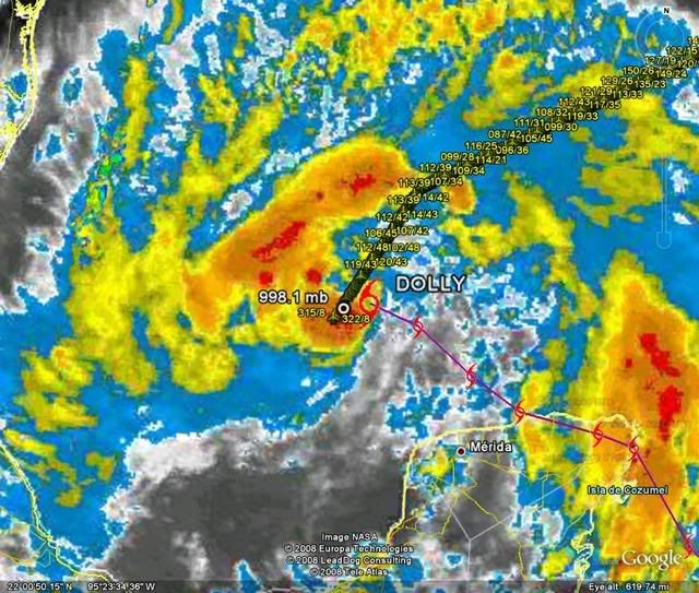
I don't know if this image is accurate but if it is then Dolly has been moving generally NW throughout the day and not W/WNW like some have claimed.
0 likes
-
JtSmarts

- S2K Supporter

- Posts: 1442
- Age: 40
- Joined: Thu Jul 10, 2003 1:29 pm
- Location: Columbia, South Carolina
Re: ATL: TS Dolly in Southern Gulf of Mexico
sphelps8681 wrote:Any chance this thing could start going more North as far as land fall? I am a planner and want more than 1 day notice to plan. I live N. of Beaumont in Lumberton. Don't want to stick around if you know what I mean.
BTW - Flashback to Rita
Just in case you didn't know, this thread is the best to get some answers from our excellent pro mets.
viewtopic.php?f=29&t=101823
0 likes
-
carversteve
- Tropical Storm
- Posts: 161
- Joined: Sat Aug 18, 2007 7:40 am
Re: ATL: TS Dolly in Southern Gulf of Mexico
Just a question....what would keep this from intensifying to say a cat 3 or 4 before landfall? besides it running out of water..If it truly under goes rapid developement.
0 likes
Re: ATL: TS Dolly in Southern Gulf of Mexico
carversteve wrote:Just a question....what would keep this from intensifying to say a cat 3 or 4 before landfall? besides it running out of water..If it truly under goes rapid developement.
Nothing much beside its structure which is continuing to improve. The TCHP isn't that good, but it is good enough for a strong cat3/weak 4. Its not anything like Wilma and Katrina had though.
Last edited by RL3AO on Mon Jul 21, 2008 6:13 pm, edited 1 time in total.
0 likes
-
mf_dolphin

- Category 5
- Posts: 17758
- Age: 69
- Joined: Tue Oct 08, 2002 2:05 pm
- Location: St Petersburg, FL
- Contact:
OK folks! I think we've had enough of the endless banter. There will be people looking for good information about Dolly and they shouldn't have to dredge through all this mindlessness to find it. Either stay on topic or I'll have the staff just start deleting posts and giving out some short vacations......
If you want to post your own forecast please start your own thread and title it "Personal forecast - username" . Thanks.
If you want to post your own forecast please start your own thread and title it "Personal forecast - username" . Thanks.
0 likes
-
wxman57

- Moderator-Pro Met

- Posts: 23172
- Age: 68
- Joined: Sat Jun 21, 2003 8:06 pm
- Location: Houston, TX (southwest)
Re: ATL: TS Dolly in Southern Gulf of Mexico
Busy day. Got up at 3:30am and was at work by 5. Left the office at 4:30pm. I see there's a discussion about Dolly's current movement. I just opened up GARP from home and I put my cursor on the 1545Z position, advanced it to 2245Z and measure a heading of 290.7 degrees and a movement of 125nm. That's a forward speed of 17.9 kts.
I get a 3-hr movement toward 293 degrees and 49nm, or 16.3 kts. So it appears to be slowing down. So no evidence of NW motion, just WNW (between 281 deg and 304 deg). NW starts at 305 degrees.
Dolly does look like it's about to enter a period of rapid intensification. Cat 2 looking likely by landfall if the current trend continues, and Cat 3 could be easily attainable. We're going with 100 mph for now. May have to up that tomorrow. Might see an eye peek out by tomorrow night.
0 likes
-
MGC

- S2K Supporter
- Posts: 5940
- Joined: Sun Mar 23, 2003 9:05 pm
- Location: Pass Christian MS, or what is left.
Re: ATL: TS Dolly in Southern Gulf of Mexico
Dolly continues to become better organize this afternoon. Convection is starting to fire near the circulation center. If this trend continues Dolly could reach hurricane intensity as early as tomorrow morning. Considering the warm water and ideal upper level conditions ahead of Dolly's forecast path, Dolly could become a strong Cat-2 hurricane prior to landfall in southern Texas, just north of Brownville.....MGC
The above statement is my opinion and is not endorsed by S2K.org
The above statement is my opinion and is not endorsed by S2K.org
0 likes
-
carversteve
- Tropical Storm
- Posts: 161
- Joined: Sat Aug 18, 2007 7:40 am
Re: ATL: TS Dolly in Southern Gulf of Mexico
RL3AO wrote:carversteve wrote:Just a question....what would keep this from intensifying to say a cat 3 or 4 before landfall? besides it running out of water..If it truly under goes rapid developement.
Nothing much beside its structure which is continuing to improve. The TCHP isn't that good, but it is good enough for a strong cat3/weak 4. Its not anything like Wilma and Katrina had though.
Thank you..because i do remember some canes getting real strong real fast...names escape me,but i do recall some.Didn't katrina blow up pretty quick once it got out of florida?
0 likes
-
Ed Mahmoud
Re: ATL: TS Dolly in Southern Gulf of Mexico
TexWx wrote:http://www.ssd.noaa.gov/goes/east/gmex/loop-rgb.html
south of track.
click on Trop Fcst Points.
I still think it is moving between W and WNW, however, with storms developing over the circulation, it isn't as easy to be certain the last couple of frames. It was moving about 285º earlier this afternoon when I did some math, got corrected, and redid the math.
It'll be too dark for visible in a couple of hours, and until it forms a clear eye, it'll be hard to tell which direction it is heading except by recon fixes.
I guess one can do math between last VDM center and next one and get a direction.
0 likes
-
srainhoutx

- S2K Supporter
- Posts: 6919
- Age: 68
- Joined: Sun Jan 14, 2007 11:34 am
- Location: Haywood County, NC
- Contact:
Re: ATL: TS Dolly in Southern Gulf of Mexico
wxman57 wrote:Busy day. Got up at 3:30am and was at work by 5. Left the office at 4:30pm. I see there's a discussion about Dolly's current movement. I just opened up GARP from home and I put my cursor on the 1545Z position, advanced it to 2245Z and measure a heading of 290.7 degrees and a movement of 125nm. That's a forward speed of 17.9 kts.
I get a 3-hr movement toward 293 degrees and 49nm, or 16.3 kts. So it appears to be slowing down. So no evidence of NW motion, just WNW (between 281 deg and 304 deg). NW starts at 305 degrees.
Dolly does look like it's about to enter a period of rapid intensification. Cat 2 looking likely by landfall if the current trend continues, and Cat 3 could be easily attainable. We're going with 100 mph for now. May have to up that tomorrow. Might see an eye peek out by tomorrow night.
Thanks wxman57. I hoped you would chime in on the madness.
0 likes
-
Smurfwicked
- Tropical Storm
- Posts: 164
- Age: 41
- Joined: Mon Sep 03, 2007 7:47 pm
- Location: SETX
Re: ATL: TS Dolly in Southern Gulf of Mexico
TexWx wrote:http://www.ssd.noaa.gov/goes/east/gmex/loop-rgb.html
south of track.
click on Trop Fcst Points.
I'm not a pro but...
Looks to me like its angled to go skirt north of those points. I agree with all the other people who claim they're starting to see more of NW movement as well. JMO is anybody else in agreement with that?
I am also curious to know when she'll slow down, that seems to me like it'll directly affect the direction in more of a NW manner too.
0 likes
-
HarlequinBoy

- Category 5
- Posts: 1400
- Age: 35
- Joined: Wed Nov 29, 2006 1:57 am
- Location: Memphis
Re: Re:
RL3AO wrote:RL3AO wrote:We are one burst of covection away from this board going "this won't even become a hurricane" to "this will be a major hurricane tomorrow".
It took 62 minutes for my prediction to come true.
I know right?
Anyway.. the five furthest south counties in Texas along the coast have populations of -
Cameron County - 335,000
Willacy County - 20,000
Kennedy County - 400 (LOL!)
Kleberg County - 31,000
Nueces County - 313,000
And then a county inland you have -
Hidalgo County - 570,000
Brooks County - 7,000
Jim Well County - 40,000
0 likes
Who is online
Users browsing this forum: No registered users and 81 guests