ATL: Tropical Depression Dolly

Moderator: S2k Moderators

Message
Author
Ed Mahmoud

Re: ATL: H Dolly in Western Gulf of Mexico

#6941 Postby Ed Mahmoud » Tue Jul 22, 2008 10:19 pm

OuterBanker wrote:I think KWT was including chaos and confusion as states.

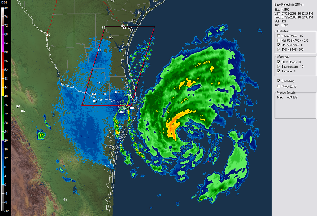
I haven't been here much of past two days because of business. Not lack of interest. I think the biggest concern would be a slow moving hurricane containing lots of rain with sustained hurricane force winds. Has s Texas received a lot of rain recently? Will S Padre Island flood because of storm surge. 10 to 15 inches of rain would flood anyone, anywhere. A few prayers for Texas tonight.


Most of South Texas has been in a moderate to severe drought.


Image
0 likes   

User avatar
ROCK
Category 5
Category 5
Posts: 9484
Age: 54
Joined: Tue Aug 17, 2004 7:30 am
Location: Kemah, Texas

Re: ATL: H Dolly in Western Gulf of Mexico

#6942 Postby ROCK » Tue Jul 22, 2008 10:19 pm

Ed Mahmoud wrote:
KatDaddy wrote:Guess Joe B forgot about his 1989 analog year..............Allison, Chantal, and Jerry. The chance of another Texas threat is very possible this year.


In fairness, West of I-45 in Harris County, most people could hardly tell a minimal Cat 1 had hit Galveston.


Jerry was also one of only 2 October hurricanes to hit Texas in 60 years.


Fairness? was a cat1 and hit TX after Allison....Its not law of averages Ed, it call unlucky.
0 likes   

RL3AO
Moderator-Pro Met
Moderator-Pro Met
Posts: 16308
Joined: Thu Jun 14, 2007 10:03 pm
Location: NC

Re: ATL: H Dolly in Western Gulf of Mexico

#6943 Postby RL3AO » Tue Jul 22, 2008 10:20 pm

cheezyWXguy wrote:can you back up your info or are you just assuming?


Nice catch. :D

MAXIMUM SUSTAINED WINDS ARE NEAR 80 MPH...130 KM/HR...WITH HIGHER
GUSTS. DOLLY IS A CATEGORY ONE HURRICANE ON THE SAFFIR-SIMPSON
SCALE. SOME ADDITIONAL STRENGTHENING IS EXPECTED PRIOR TO LANDFALL.
0 likes   

User avatar
baygirl_1
S2K Supporter
S2K Supporter
Posts: 825
Joined: Wed Aug 11, 2004 4:06 pm
Location: Mobile, AL

Re:

#6944 Postby baygirl_1 » Tue Jul 22, 2008 10:21 pm

RL3AO wrote:Important note from the discussion IMO.
SHOULD DOLLY SLOW AS MUCH AS THE GFS IS FORECASTING...THE CURRENT
RAINFALL ESTIMATES...OF UP TO 15 INCHES IN SPOTS...WILL LIKELY BE
LOW.

Okay, does this storm remind anyone else of Danny in 1997? Areas around Mobile Bay received 20"-40" of rain during that storm. It was awful! I certainly hope Dolly doesn't do that to Texas and Mexico.
Here's more on Danny: http://www.usouthal.edu/meteorology/hurricanedanny.html
0 likes   

OuterBanker
S2K Supporter
S2K Supporter
Posts: 1733
Joined: Wed Feb 26, 2003 10:53 am
Location: Nags Head, NC
Contact:

#6945 Postby OuterBanker » Tue Jul 22, 2008 10:24 pm

Has there been a post yet of the number and names of affected members?
0 likes   

Ed Mahmoud

Re: ATL: H Dolly in Western Gulf of Mexico

#6946 Postby Ed Mahmoud » Tue Jul 22, 2008 10:24 pm

Not betting the farm on this, but I think center is just Northeast of coldest (white) cloud tops, and a band is trying to 'backbuild (but to the East) around the center.

On this radar loop
0 likes   

Ed Mahmoud

Re:

#6947 Postby Ed Mahmoud » Tue Jul 22, 2008 10:26 pm

OuterBanker wrote:Has there been a post yet of the number and names of affected members?


lrak (name is Karl) lives near Corpus Christi, and a couple of Rio Grande Valley residents have posted on local impact/report/warning thread.
0 likes   

stevetampa33614

Re: ATL: H Dolly in Western Gulf of Mexico

#6948 Postby stevetampa33614 » Tue Jul 22, 2008 10:27 pm

can you back up your info or are you just assuming?


How about learning to use the Internet? A simple google search yields the result.

http://flhurricane.com/cyclone/stormspo ... 08&storm=4
Last edited by stevetampa33614 on Tue Jul 22, 2008 10:28 pm, edited 1 time in total.
0 likes   

hurrican19
Tropical Storm
Tropical Storm
Posts: 153
Joined: Sun Jun 13, 2004 1:36 pm
Location: Northwest Austin, TX

Pictures from Galveston today

#6949 Postby hurrican19 » Tue Jul 22, 2008 10:28 pm

Here are some pics I snapped from Galveston today.. I was suprised by the wind on the beach, and the wave heights.. All pics taken from my cell..

Image

Image

Image

Image

Image
0 likes   

CrazyC83
Professional-Met
Professional-Met
Posts: 34002
Joined: Tue Mar 07, 2006 11:57 pm
Location: Deep South, for the first time!

#6950 Postby CrazyC83 » Tue Jul 22, 2008 10:29 pm

Tornado Watch issued...
0 likes   

User avatar
cheezyWXguy
Category 5
Category 5
Posts: 6108
Joined: Mon Feb 13, 2006 12:29 am
Location: Dallas, TX

Re: ATL: H Dolly in Western Gulf of Mexico

#6951 Postby cheezyWXguy » Tue Jul 22, 2008 10:29 pm

stevetampa33614 wrote:
can you back up your info or are you just assuming?


How about learning to use Internet? A simple google search yields the result.

http://flhurricane.com/cyclone/stormspo ... 08&storm=4

Ok umm assuming Im stupid, why dont you check the intensity on what you just posted? It says its 80mph, not 85...get your facts straight.
0 likes   

CrazyC83
Professional-Met
Professional-Met
Posts: 34002
Joined: Tue Mar 07, 2006 11:57 pm
Location: Deep South, for the first time!

#6952 Postby CrazyC83 » Tue Jul 22, 2008 10:29 pm

SEL2

URGENT - IMMEDIATE BROADCAST REQUESTED
TORNADO WATCH NUMBER 732
NWS STORM PREDICTION CENTER NORMAN OK
1025 PM CDT TUE JUL 22 2008

THE NWS STORM PREDICTION CENTER HAS ISSUED A
TORNADO WATCH FOR PORTIONS OF

DEEP SOUTH TEXAS
COASTAL WATERS

EFFECTIVE THIS TUESDAY NIGHT AND WEDNESDAY MORNING FROM 1025 PM
UNTIL 1000 AM CDT.

TORNADOES...THUNDERSTORM WIND GUSTS TO 70 MPH...AND DANGEROUS
LIGHTNING ARE POSSIBLE IN THESE AREAS.

THE TORNADO WATCH AREA IS APPROXIMATELY ALONG AND 40 STATUTE
MILES EAST AND WEST OF A LINE FROM 25 MILES SOUTHEAST OF MCALLEN
TEXAS TO 10 MILES EAST OF CORPUS CHRISTI TEXAS. FOR A COMPLETE
DEPICTION OF THE WATCH SEE THE ASSOCIATED WATCH OUTLINE UPDATE
(WOUS64 KWNS WOU2).

REMEMBER...A TORNADO WATCH MEANS CONDITIONS ARE FAVORABLE FOR
TORNADOES AND SEVERE THUNDERSTORMS IN AND CLOSE TO THE WATCH
AREA. PERSONS IN THESE AREAS SHOULD BE ON THE LOOKOUT FOR
THREATENING WEATHER CONDITIONS AND LISTEN FOR LATER STATEMENTS
AND POSSIBLE WARNINGS.

OTHER WATCH INFORMATION...CONTINUE...WW 730...WW 731...

DISCUSSION...RAIN BANDS ASSOCIATED WITH LAND FALLING HURRICANE DOLLY
WILL INCREASE ACROSS DEEP SOUTH TX OVERNIGHT AND EARLY WEDNESDAY
MORNING. ASSOCIATED THREAT OF WATERSPOUTS/TORNADOES WILL LIKEWISE
INTENSIFY DURING THE NIGHT.

AVIATION...TORNADOES AND A FEW SEVERE THUNDERSTORMS WITH EXTREME
TURBULENCE AND SURFACE WIND GUSTS TO 60 KNOTS. A FEW CUMULONIMBI
WITH MAXIMUM TOPS TO 600. MEAN STORM MOTION VECTOR 03040.


...EVANS
0 likes   

stevetampa33614

Re: ATL: H Dolly in Western Gulf of Mexico

#6953 Postby stevetampa33614 » Tue Jul 22, 2008 10:30 pm

RL3AO wrote:
cheezyWXguy wrote:can you back up your info or are you just assuming?


Nice catch. :D

MAXIMUM SUSTAINED WINDS ARE NEAR 80 MPH...130 KM/HR...WITH HIGHER
GUSTS. DOLLY IS A CATEGORY ONE HURRICANE ON THE SAFFIR-SIMPSON
SCALE. SOME ADDITIONAL STRENGTHENING IS EXPECTED PRIOR TO LANDFALL.


Well never get info from another forum. 80 NOT 86
0 likes   

Ed Mahmoud

Re: ATL: H Dolly in Western Gulf of Mexico

#6954 Postby Ed Mahmoud » Tue Jul 22, 2008 10:31 pm

Windspeed still pretty low in Laguna Madre between CRP and BRO.

I expect that to change shortly


Observation from Rincon del San Jose; Potrero Lopeno SW, TX
0 likes   

RL3AO
Moderator-Pro Met
Moderator-Pro Met
Posts: 16308
Joined: Thu Jun 14, 2007 10:03 pm
Location: NC

Re: ATL: H Dolly in Western Gulf of Mexico

#6955 Postby RL3AO » Tue Jul 22, 2008 10:31 pm

Image

Tornadoes

Probability of 2 or more tornadoes
Mod (40%)
Probability of 1 or more strong (F2-F5) tornadoes
Low (20%)

Wind

Probability of 10 or more severe wind events
Low (10%)
Probability of 1 or more wind events > 65 knots
Low (10%)

Hail

Probability of 10 or more severe hail events
Low (<5%)
Probability of 1 or more hailstones > 2 inches
Low (<5%)

Combined Severe Hail/Wind

Probability of 6 or more combined severe hail/wind events
Mod (30%)
Last edited by RL3AO on Tue Jul 22, 2008 10:32 pm, edited 1 time in total.
0 likes   

User avatar
jasons2k
Storm2k Executive
Storm2k Executive
Posts: 8245
Age: 51
Joined: Wed Jul 06, 2005 12:32 pm
Location: The Woodlands, TX

Re: ATL: H Dolly in Western Gulf of Mexico

#6956 Postby jasons2k » Tue Jul 22, 2008 10:33 pm

Image

Time to crash, see you on the flip. Prayers for the LRGV region for sure. This is one prediction I didn't want to see come true.
0 likes   

User avatar
artist
Category 5
Category 5
Posts: 9792
Joined: Mon Jun 06, 2005 3:26 pm
Location: West Palm

Re: ATL: H Dolly in Western Gulf of Mexico

#6957 Postby artist » Tue Jul 22, 2008 10:34 pm

stevetampa33614 wrote:
RL3AO wrote:
cheezyWXguy wrote:can you back up your info or are you just assuming?


Nice catch. :D

MAXIMUM SUSTAINED WINDS ARE NEAR 80 MPH...130 KM/HR...WITH HIGHER
GUSTS. DOLLY IS A CATEGORY ONE HURRICANE ON THE SAFFIR-SIMPSON
SCALE. SOME ADDITIONAL STRENGTHENING IS EXPECTED PRIOR TO LANDFALL.


Well never get info from another forum. 80 NOT 86

common courtesy goes a long way. Around here people are usually asked to supply a reasoning behind their statement or if it is from an advisory to actually mention it. Not just throw something out there. It is also against board rules to post other forums. Since you are fairly new I feel certain you didn't realize this yet. Just thought you might like to know.
0 likes   

User avatar
ROCK
Category 5
Category 5
Posts: 9484
Age: 54
Joined: Tue Aug 17, 2004 7:30 am
Location: Kemah, Texas

Re: ATL: H Dolly in Western Gulf of Mexico

#6958 Postby ROCK » Tue Jul 22, 2008 10:42 pm

ULL to her NW is eating at her...see her flatten out on the NW...ULL to the SW restricting as well....trof digging in the plains.....she really is moving slow in the last few frames...


http://www.srh.noaa.gov/tropical/satpix ... v_loop.php
0 likes   

User avatar
srainhoutx
S2K Supporter
S2K Supporter
Posts: 6919
Age: 67
Joined: Sun Jan 14, 2007 11:34 am
Location: Haywood County, NC
Contact:

Re: ATL: H Dolly in Western Gulf of Mexico

#6959 Postby srainhoutx » Tue Jul 22, 2008 10:43 pm

jasons wrote:Time to crash, see you on the flip. Prayers for the LRGV region for sure. This is one prediction I didn't want to see come true.


Good night Jason. Agree with the prayers fro the LRGV.
0 likes   

User avatar
HarlequinBoy
Category 5
Category 5
Posts: 1400
Age: 34
Joined: Wed Nov 29, 2006 1:57 am
Location: Memphis

#6960 Postby HarlequinBoy » Tue Jul 22, 2008 10:44 pm

This could be a major flood event for deep south Texas. She's moving pretty slow. She may be a drought buster in some areas as well, but along the border this will be a serious flood situation, imo.
0 likes   


Return to “2008”

Who is online

Users browsing this forum: No registered users and 1 guest