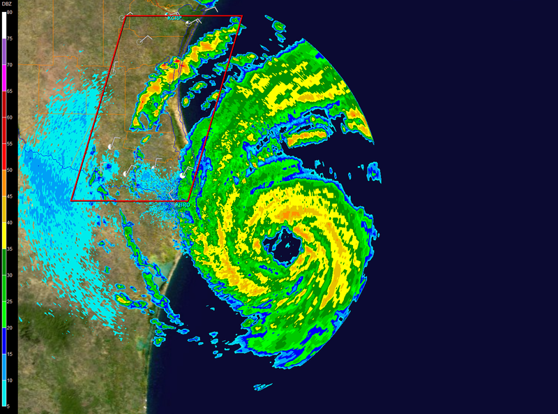
ekal wrote:74 knots at the surface found via dropsonde...check recon thread.
Eyewall drosponde:
Surface Winds (986mb) 74kts
979mb 85kts
960mb 86kts
953mb 92kts
949mb 85kts
925mb 88kts
850mb 65kts
700mb 63kts
MBL Wind 88kts
Moderator: S2k Moderators
ekal wrote:74 knots at the surface found via dropsonde...check recon thread.
kurtpage wrote:ekal wrote:74 knots at the surface found via dropsonde...check recon thread.
Eyewall drosponde:
Surface Winds (986mb) 74kts
979mb 85kts
960mb 86kts
953mb 92kts
949mb 85kts
925mb 88kts
850mb 65kts
700mb 63kts
MBL Wind 88kts


americanrebel wrote:kurtpage wrote:ekal wrote:74 knots at the surface found via dropsonde...check recon thread.
Eyewall drosponde:
Surface Winds (986mb) 74kts
979mb 85kts
960mb 86kts
953mb 92kts
949mb 85kts
925mb 88kts
850mb 65kts
700mb 63kts
MBL Wind 88kts
So if I understand this correctly we have a 88Kt Hurricane, which is about 100 MPH (correct?).


dhsgal wrote:Pebbles wrote:dhsgal wrote:new here...where do I click once I get to web site to see what your looking at?
On the left hand side.. you'll see where it say simulated radar. The boxes under there.
BTW.. this is very experimental... don't take it to heart. I only brought it up to perk up the late night discussion a bit as it tends to get quiet and the wierd landfall talk had come up.
Thanks, I am trying to learn since I am in the business of the aftermath of mother natures destruction!
cheezyWXguy wrote:americanrebel wrote:kurtpage wrote:
Eyewall drosponde:
Surface Winds (986mb) 74kts
979mb 85kts
960mb 86kts
953mb 92kts
949mb 85kts
925mb 88kts
850mb 65kts
700mb 63kts
MBL Wind 88kts
So if I understand this correctly we have a 88Kt Hurricane, which is about 100 MPH (correct?).
WHAT? where do you get that?
ekal wrote:No. 88 knots is above the surface at 925mb. At the surface (986 mb), we have 74 knots.


Pebbles wrote:Here's my dirty late night secret. A teeny tiny part of me almost wishes that 'weird' ride the coast solution would happen just to see Derek freak out.
But then I would immediately feel guilty for having wished such a thing on anyone.
Yeah, I feel kind of bad for Brownsville too. But maybe some of those desperately needing rain might get some relief. Have to try to find some sort of silver lining.
zaqxsw75050 wrote:Is it just me or the eye on the radar is getting smaller? Also, there is some green dot going around the eye. Could that be some little vortex inside the eyewall?
Users browsing this forum: No registered users and 20 guests