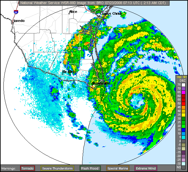
Westward movement is apparent now, as is solidification of the middle bands on radar.
Brownsville is really going to get raked by the right flank. The south-border plywood shantytowns are toast, IMO. I hope nobody's still in 'em.
ATL: Tropical Depression Dolly
Moderator: S2k Moderators
-
HarlequinBoy

- Category 5

- Posts: 1400
- Age: 35
- Joined: Wed Nov 29, 2006 1:57 am
- Location: Memphis

-
paintplaye
- Category 1

- Posts: 380
- Joined: Sun Jul 20, 2008 11:25 pm
Re: ATL: H Dolly in Western Gulf of Mexico
Honeyko wrote:Westward movement is apparent now, as is solidification of the middle bands on radar.
Brownsville is really going to get raked by the right flank. The south-border plywood shantytowns are toast, IMO. I hope nobody's still in 'em.
No it still is a wnw movement. i agree though Brownsville is going to get hit hard.
0 likes

-
Matt-hurricanewatcher
Re: ATL: H Dolly in Western Gulf of Mexico
I pin hole eye is becoming clear on IR. If current trends keep up I expect this to be around 90-95 mph by 8am. But who knows I could be tricked by this weird storm once again.
0 likes


-
Honeyko
There's three or four mesos rolling around the "bowl" of a forming larger, outer eyewall now. It looks like a mess on radar, but don't be fooled -- the cells associated with the mesos will have the strongest gusts in the storm.
First-light visibles promise to be interesting, provided cirrus isn't obscuring things.
First-light visibles promise to be interesting, provided cirrus isn't obscuring things.
0 likes
-
americanrebel
Re: ATL: H Dolly in Western Gulf of Mexico
Looks like she has moved a WHOLE 5 miles in the last hour on a due NW path.
0 likes


-
paintplaye
- Category 1
- Posts: 380
- Joined: Sun Jul 20, 2008 11:25 pm
Re:
Starburst wrote:according to the last vortex it is heading 320
That would take it right above Brownsville.
0 likes
One note...several have mentioned shantytowns on the south side of the border....from experience these are normally built on land no one wants....such as old river channels, low lying, floodable. The wind may not be as big as a problem as water may be down the road. The other part would be the tides....when is high tide for the coast such as S Padre Island?
Last edited by hiflyer on Wed Jul 23, 2008 3:12 am, edited 1 time in total.
0 likes
-
HarlequinBoy
- Category 5
- Posts: 1400
- Age: 35
- Joined: Wed Nov 29, 2006 1:57 am
- Location: Memphis
Re:
ca12los wrote:Update from Brownsville:
Still awaiting tropical storm force winds.....
People are going to wake up to a cat 2 I believe. Dolly is looking terrific. I am starting to get the jitters now.
Best luck to you. Hunker down and stay safe!
0 likes
-
SouthFloridawx

- S2K Supporter

- Posts: 8346
- Age: 47
- Joined: Tue Jul 26, 2005 1:16 am
- Location: Sarasota, FL
- Contact:
Re: ATL: H Dolly in Western Gulf of Mexico
I kind of figured this would bomb out a little before landfall. I hope it doesn't get any worse.
0 likes
-
paintplaye
- Category 1
- Posts: 380
- Joined: Sun Jul 20, 2008 11:25 pm
Who is online
Users browsing this forum: No registered users and 22 guests