
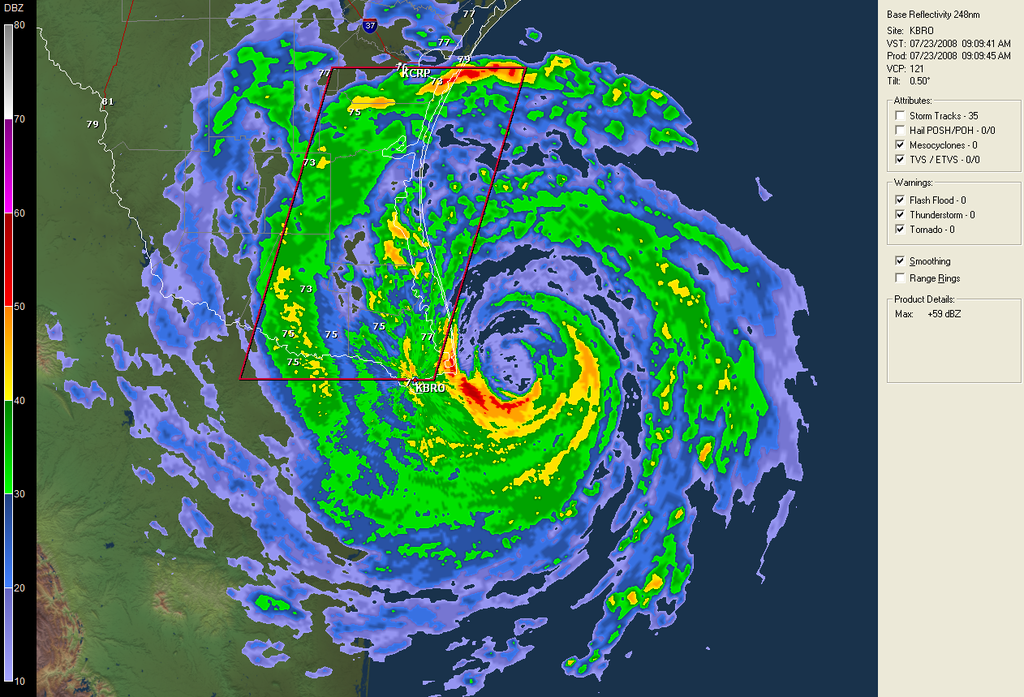
Eye doesn't look quite as impressive Hurakan but thats to be expected given how close it is to land at the preset moment.
Texas Snowman, yep pressure certainly is more akin to a high end category-2 rather then a high end cat-1.
ATL: Tropical Depression Dolly
Moderator: S2k Moderators

Re:
Chacor wrote:WWUS84 KBRO 231403
SPSBRO
SPECIAL WEATHER STATEMENT
NATIONAL WEATHER SERVICE BROWNSVILLE TX
903 AM CDT WED JUL 23 2008
TXZ254>257-231615-
INLAND WILLACY-INLAND CAMERON-COASTAL WILLACY-COASTAL CAMERON-
INCLUDING THE CITIES OF...RAYMONDVILLE...BROWNSVILLE...
HARLINGEN...PORT MANSFIELD...PORT ISABEL...SOUTH PADRE ISLAND...
LAGUNA HEIGHTS...LAGUNA VISTA
903 AM CDT WED JUL 23 2008
...HURRICANE FORCE WINDS IMMINENT...
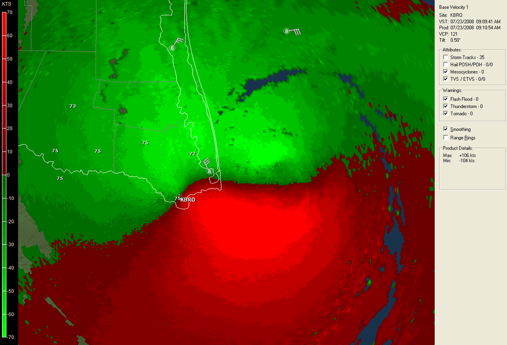
NATIONAL WEATHER SERVICE DOPPLER RADAR SHOWS THE EYE OF POWERFUL
HURRICANE DOLLY APPROACHING THE LOWER TEXAS COAST AT THIS TIME.
HURRICANE FORCE WINDS WILL SPREAD INTO CAMERON AND WILLACY COUNTY
DURING THE NEXT COUPLE OF HOURS. SUSTAINED NORTHERLY WINDS OF AT
LEAST 75 MILES PER HOUR...WITH GUSTS UP TO 95 MILES PER HOUR...ARE
LIKELY.
RESIDENTS ARE URGED TO TAKE COVER IMMEDIATELY. DO NOT GO OUTSIDE
WHEN THE EYE OF HURRICANE DOLLY MOVES ONSHORE...AS DAMAGED TREES
...POWERLINES...AND BUILDINGS WILL BE HAZARDOUS TO ANYONE OUTDOORS.
$$
TOMASELLI
In case it got lost on the previous page.
0 likes
-
Extremeweatherguy

- Category 5

- Posts: 11095
- Joined: Mon Oct 10, 2005 8:13 pm
- Location: Florida

-
CrazyC83
- Professional-Met

- Posts: 34315
- Joined: Tue Mar 07, 2006 11:57 pm
- Location: Deep South, for the first time!
Re: ATL: H Dolly in Western Gulf of Mexico
MiamiensisWx wrote:Old VDM:
URNT12 KNHC 231320
VORTEX DATA MESSAGE AL042008
A. 23/13:17:40Z
B. 25 deg 53 min N
096 deg 47 min W
C. 700 mb 2785 m
D. 70 kt
E. 175 deg 10 nm
F. 265 deg 071 kt
G. 174 deg 009 nm
H. EXTRAP 964 mb
I. 10 C/ 3048 m
J. 17 C/ 3048 m
K. 9 C/ NA
L. C20
M. CLOSED
N. 12345/7
O. 0.02 / NA nm
P. AF302 1904A DOLLY OB 22
MAX FL WIND 92 KT N QUAD 12:08:50 Z
SLP EXTRAP FROM 700 MB
PRELIMINARY
Would a flight level reading of 92 kt support 85 kt at the surface?
Supports 83 kt, but given the pressure I would go 85 kt.
0 likes
Re: ATL: H Dolly in Western Gulf of Mexico
Have to be careful with intensity speculation. Last year people were hyping that all the towns where Dean went in were being ripped from their foundations and flung through the air. Afterwards the storm assessment wasn't as bad as that. Now is where Dolly will tap out its SST source.
0 likes
-
Texas Snowman

- Storm2k Moderator

- Posts: 6197
- Joined: Fri Jan 25, 2008 11:29 am
- Location: Denison, Texas
Re: ATL: H Dolly in Western Gulf of Mexico
Whoa, that Dvorak image is amazing in appearance - impressive looking storm.
Dolly's punch is going to be pretty bad I'm afraid. Wonder if it will get into the Beulah category?
Dolly's punch is going to be pretty bad I'm afraid. Wonder if it will get into the Beulah category?
0 likes
-
Texas Snowman
- Storm2k Moderator
- Posts: 6197
- Joined: Fri Jan 25, 2008 11:29 am
- Location: Denison, Texas
Re: ATL: H Dolly in Western Gulf of Mexico
KWT,
What is the increase in damage potential from high end 1 to high end 2?
What is the increase in damage potential from high end 1 to high end 2?
0 likes
Re: ATL: H Dolly in Western Gulf of Mexico
CrazyC83 wrote:MiamiensisWx wrote:Old VDM:
URNT12 KNHC 231320
VORTEX DATA MESSAGE AL042008
A. 23/13:17:40Z
B. 25 deg 53 min N
096 deg 47 min W
C. 700 mb 2785 m
D. 70 kt
E. 175 deg 10 nm
F. 265 deg 071 kt
G. 174 deg 009 nm
H. EXTRAP 964 mb
I. 10 C/ 3048 m
J. 17 C/ 3048 m
K. 9 C/ NA
L. C20
M. CLOSED
N. 12345/7
O. 0.02 / NA nm
P. AF302 1904A DOLLY OB 22
MAX FL WIND 92 KT N QUAD 12:08:50 Z
SLP EXTRAP FROM 700 MB
PRELIMINARY
Would a flight level reading of 92 kt support 85 kt at the surface?
Well its close, you could go either way with that, tobe honest though wit hthe pressure as well as radar suggestive of a stronger storm I'd go with 85kts rather then 80kts but heck who knows!
0 likes


Re: ATL: H Dolly in Western Gulf of Mexico
hurricanelandfall wrote:
The estimates are near 6.0 or cat 4 intensity...maybe the winds will increase and pressure continue falling.

I'd suggest avoid relying on Dvorak analyses (based solely on imagery) when we have recon data.
Last edited by Chacor on Wed Jul 23, 2008 9:14 am, edited 1 time in total.
0 likes
-
CrazyC83
- Professional-Met
- Posts: 34315
- Joined: Tue Mar 07, 2006 11:57 pm
- Location: Deep South, for the first time!
Re: ATL: H Dolly in Western Gulf of Mexico
hurricanelandfall wrote:
The estimates are near 6.0 or cat 4 intensity...maybe the winds will increase and pressure continue falling.
We're lucky that Dolly doesn't have another 12 hours in the water or she would likely get that strong.
0 likes

-
hurricanefloyd5

- Category 5
- Posts: 1659
- Age: 45
- Joined: Sun May 02, 2004 10:53 am
- Location: Spartanburg
- Contact:
Re: ATL: H Dolly in Western Gulf of Mexico
http://www.wftv.com/video/16964050/inde ... orlc_break
try this this is from my local tv station here in orlando florida!!!!!!!!!!!!
try this this is from my local tv station here in orlando florida!!!!!!!!!!!!
0 likes
Re: ATL: H Dolly in Western Gulf of Mexico
That dry slot will keep any further intensification from happening, in my opinion.
0 likes
Re: ATL: H Dolly in Western Gulf of Mexico
they always say front right quadrant is the worst (i know it is for surge) but i thought they say for winds as well, and my guess is if the eye appearance maintains the strongest echoes SW along the eye wall, these areas should get the highest winds, correct?
0 likes
Who is online
Users browsing this forum: No registered users and 24 guests