ATL: Tropical Depression Dolly
Moderator: S2k Moderators
-
Brent
- S2K Supporter

- Posts: 38729
- Age: 37
- Joined: Sun May 16, 2004 10:30 pm
- Location: Tulsa Oklahoma
- Contact:
Re: ATL: H Dolly in Western Gulf of Mexico
raindrops68 wrote:Johnny wrote:Avila hard at work.
What station is that on the tv?

Looks like CNN to me.
0 likes

-
weatherrabbit_tx

- Category 1

- Posts: 270
- Joined: Wed Dec 21, 2005 3:13 pm
- Location: Kingwood,Tx
- Contact:
Re: ATL: H Dolly in Western Gulf of Mexico
raindrops68 wrote:Johnny wrote:Avila hard at work.
What station is that on the tv?
no tv station, I wish, we'd all be tuned in.......
0 likes
-
orion

- S2K Supporter
- Posts: 165
- Joined: Mon Aug 02, 2004 5:44 pm
- Location: Indian Harbour Beach, FL
- Contact:
Re: ATL: H Dolly in Western Gulf of Mexico
Good graph from Station PTIT2 - 8779770 - Port Isabel, TX showing the pressure decreasing and winds increasing as the eye passed by...
http://www.ndbc.noaa.gov/show_plot.php?station=ptit2&meas=wdpr&uom=E&time_diff=5&time_label=CDT
http://www.ndbc.noaa.gov/show_plot.php?station=ptit2&meas=wdpr&uom=E&time_diff=5&time_label=CDT
0 likes
-
orion
- S2K Supporter
- Posts: 165
- Joined: Mon Aug 02, 2004 5:44 pm
- Location: Indian Harbour Beach, FL
- Contact:
Re: ATL: H Dolly in Western Gulf of Mexico
weatherrabbit_tx wrote: no tv station, I wish, we'd all be tuned in.......
I think they were talking about the TV mounted up in the corner... I wish we could get that view on that wide screen Avila is watching!!
0 likes
-
cycloneye

- Admin

- Posts: 149276
- Age: 69
- Joined: Thu Oct 10, 2002 10:54 am
- Location: San Juan, Puerto Rico
Re: ATL: H Dolly in Western Gulf of Mexico
AT 400 PM CDT...2100Z...THE EYE OF HURRICANE DOLLY WAS LOCATED
NEAR LATITUDE 26.6 NORTH...LONGITUDE 97.6 WEST OR ABOUT 50 MILES...
80 KM...NORTH OF BROWNSVILLE TEXAS.
DOLLY IS MOVING TOWARD THE NORTHWEST NEAR 8 MPH...13 KM/HR. A
GRADUAL TURN TO THE WEST-NORTHWEST AND WEST IS EXPECTED DURING THE
NEXT DAY OR SO. THIS WILL BRING DOLLY FARTHER INLAND OVER SOUTHER
TEXAS.
MAXIMUM SUSTAINED WINDS HAVE DECREASED TO NEAR 85 MPH...140
KM/HR...WITH HIGHER GUSTS. DOLLY IS A CATEGORY ONE HURRICANE ON
THE SAFFIR-SIMPSON SCALE. FURTHER WEAKENING IS FORECAST DURING THE
NEXT 24 HOURS.
0 likes
-
HouTXmetro

- Category 5

- Posts: 3949
- Joined: Sun Jun 13, 2004 6:00 pm
- Location: District of Columbia, USA


-
HarlequinBoy

- Category 5
- Posts: 1400
- Age: 35
- Joined: Wed Nov 29, 2006 1:57 am
- Location: Memphis


Re: ATL: H Dolly in Western Gulf of Mexico
I noticed that it is still moving NW. What happened to the westward turn it was supposed to make?
0 likes

Re: ATL: H Dolly in Western Gulf of Mexico
Wow, clouds cooling around the center again as it moves inland. Wallacy and Cameron Counties are going to get a terrible amount of rainfall
0 likes
-
wx247

- S2K Supporter
- Posts: 14279
- Age: 42
- Joined: Wed Feb 05, 2003 10:35 pm
- Location: Monett, Missouri
- Contact:
By the way, the tv station Avila is watching is CNN. That is Heidi Collins and Tony Harris anchoring.
Interesting to note that the rainfall estimate puts the rain at Brownsville at 7.75" while they have officially seen over 10. I wonder what that means about the area that have estimated 19" of rain via GRLevel 3.
Interesting to note that the rainfall estimate puts the rain at Brownsville at 7.75" while they have officially seen over 10. I wonder what that means about the area that have estimated 19" of rain via GRLevel 3.
0 likes
-
PTrackerLA

- Category 5
- Posts: 5281
- Age: 42
- Joined: Thu Oct 10, 2002 8:40 pm
- Location: Lafayette, LA
Re: ATL: H Dolly in Western Gulf of Mexico
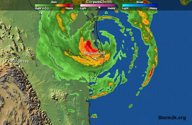
Still has an excellent satellite presentation at this time. Very intense radar returns now showing up along the highway 77 corridor. Flooding could become a serious issue in this area and I'm sure the winds are sustained at hurricane force in spots.
0 likes
-
Ed Mahmoud
Re:
wx247 wrote:By the way, the tv station Avila is watching is CNN. That is Heidi Collins and Tony Harris anchoring.
Interesting to note that the rainfall estimate puts the rain at Brownsville at 7.75" while they have officially seen over 10. I wonder what that means about the area that have estimated 19" of rain via GRLevel 3.
I have seen discussions from NWS AFDs, and apparently rain drops in tropical systems have a different size or shape, and regular doppler radar will underestimate rainfall in tropical systems. There is apparently a "tropical" mode the radar operator can select to make doppler indicated rainfull more closely approximate true measured rainfall. No idea if that has been done or not.
0 likes
-
wx247
- S2K Supporter
- Posts: 14279
- Age: 42
- Joined: Wed Feb 05, 2003 10:35 pm
- Location: Monett, Missouri
- Contact:
Serious situation in La Feria, TX at this time...
Currently there is a mandatory evacuation in La Feria: only to East Commercial St and surrounding streets due to a gas line rupture and a electrical power line down over the gas line.
Emergency personnel have blocked these surrounding roads and emergency officials have evacuated everyone who live near due to the possibility of an explosion.
via Newschannel 5, Weslaco...
0 likes
-
HarlequinBoy
- Category 5
- Posts: 1400
- Age: 35
- Joined: Wed Nov 29, 2006 1:57 am
- Location: Memphis
Who is online
Users browsing this forum: No registered users and 95 guests