I received an email from a visitor to my site just a little while ago and they mentioned something possible in the Gulf over the weekend. I had no idea so I read the Hou/Gal AFD from today and sure enough, there it is:
MARINE...
WINDS RELAXING WITH SEAS GRADUALLY COMING DOWN THIS AFTERNOON.
HAVE STRETCHED THE SCEC TIL 7 PM FOR THE 20-60NM WATERS.
OTHERWISE...LIGHT ONSHORE FLOW VARYING FROM SW TO SE AS HIGH
SETTLES OVER NW GULF THEN WEAKENS AND THEN REDEVELOPS OVER THE
EASTERN GULF ESTABLISHING A MORE SOUTHERLY FLOW. AREA OF DISTURBED
WEATHER MAY DEVELOP SOUTH OF LA/AL IN NE GULF LATE SUNDAY THAT
COULD BE WORTH MONITORING. MOISTURE SHOULD BE DRAGGED WEST FROM LA
INTO THE COASTAL WATERS TUESDAY AND WEDNESDAY AND WILL BRING A
SLIGHT CHANCE OF SHRA/TSRA.
I cannot see anything in the models that would be worth watching. Is there anything showing up that you all have seen?
Gulf of Mexico (Is Invest 91L)
Moderator: S2k Moderators
Forum rules

The posts in this forum are NOT official forecasts and should not be used as such. They are just the opinion of the poster and may or may not be backed by sound meteorological data. They are NOT endorsed by any professional institution or STORM2K. For official information, please refer to products from the National Hurricane Center and National Weather Service.
-
hurricanetrack

- HurricaneTrack.com

- Posts: 1781
- Joined: Tue Dec 02, 2003 10:46 pm
- Location: Wilmington, NC
- Contact:
Gulf of Mexico (Is Invest 91L)
0 likes

Re: Anyone else see this?
not sure about this interesting to watch (things have quieted as they should)
and from RLAO3's comment i assume he doesn't see anything although he does not seem to like the title of the thread
and from RLAO3's comment i assume he doesn't see anything although he does not seem to like the title of the thread
0 likes
-
hurricanetrack
- HurricaneTrack.com
- Posts: 1781
- Joined: Tue Dec 02, 2003 10:46 pm
- Location: Wilmington, NC
- Contact:
Re: Anyone else see this?
I did not title it anything other than what it is since that is the question. I also thought that saying anything about potential development in the Gulf would not be prudent since there is little to no evidence that anything is to develop. All I wanted to know is if anyone else had seen that AFD and then we could discuss it from there.
It has not shown up elsewhere from what I can see although there is limited and disorganized convection south of FL/AL/MS this morning. I guess it is some convergence with the east winds coming through there. Probably nothing more.
It has not shown up elsewhere from what I can see although there is limited and disorganized convection south of FL/AL/MS this morning. I guess it is some convergence with the east winds coming through there. Probably nothing more.
0 likes
-
Dean4Storms
- S2K Supporter

- Posts: 6358
- Age: 63
- Joined: Sun Aug 31, 2003 1:01 pm
- Location: Miramar Bch. FL
There is some model support from GFS and WRF for an MCS to move into the Gulf and probably is the area we see now in South Miss, AL and fixing to blow through the Panhandle. If it persists out over the Gulf into next week it could be an area of concern.
http://weather.cod.edu/forecast/
http://weather.cod.edu/forecast/
0 likes
-
Ed Mahmoud
Re: Anyone else see this?
Not much model support for development. I see a weak 500 mb vorticity on multiple models with some rain. GFS takes it back towards New Orleans in about 3 days. No model indication of a significant surface development.
I expect nothing of a tropical development. MCS move into the Gulf all the time without development. However, I do recall 1997 and Danny, and its origin as a most impressive MCS with frequent and vivid lightning as it passed my apartment in Lafayette, LA, and how local met Rob Perillo the next morning said it was a feature to watch.
Therefore, expect nothing, but check satellite loops of Gulf and pay attention to models and Gulf area NWS office AFDs. Which I do on a daily basis anyway during the season.
0 likes
-
jenmrk

- Tropical Storm

- Posts: 106
- Joined: Thu Sep 22, 2005 2:24 am
- Location: Pensacola,Florida
- Contact:
Re: Anyone else see this?
Hi,
I usually only read but I am curious of this weather that we are getting right now here in Pensacola, could be what they are hinting at, it is pretty nasty and heading toward the Gulf, at least it looks like it is. I tried to post NEXRAD but can figure out how to. I am just curious.
Thanks,
Jen
I usually only read but I am curious of this weather that we are getting right now here in Pensacola, could be what they are hinting at, it is pretty nasty and heading toward the Gulf, at least it looks like it is. I tried to post NEXRAD but can figure out how to. I am just curious.
Thanks,
Jen
0 likes
-
inda_iwall
Re: Anyone else see this?
Yes, I too am in Pensacola, and saw this system coming through and looked on the board out of curiousity for possible development, can storms like this blow off the US and develop like they do off Africa? Because this is def a surface low as my barometer fell a lot here over the past hour or more.
0 likes

Re: Anyone else see this?
I am usually just a lurker here but had to reply when i saw this topic. we had two lightening strikes at our house here in jackson county ms about 2:20 pm when this system came through.
0 likes

Re: Anyone else see this?
Sometimes the tail end of a front does cut off over the gulf and spin up. Cold fronts don't usually get very far south this time of year so its worth watching. Maybe 1 in 3 fronts leave a low at the end when they stall over the gulf?
0 likes
-
Emmett_Brown

- Category 5
- Posts: 1433
- Joined: Wed Aug 24, 2005 9:10 pm
- Location: Sarasota FL
Re: Anyone else see this?
There is a large complex of storms headed S from LA into the GOM as we speak. There is also some fairly decent upper level outflow. Perhaps this is the genesis of what they are referring to?
http://www.ssd.noaa.gov/goes/east/gmex/avn-l.jpg
http://www.ssd.noaa.gov/goes/east/gmex/avn-l.jpg
0 likes
-
Jason_B
Re: Anyone else see this?
That line came through earlier this afternoon and brought some really bad weather, had hail and some big wind.Emmett_Brown wrote:There is a large complex of storms headed S from LA into the GOM as we speak. There is also some fairly decent upper level outflow. Perhaps this is the genesis of what they are referring to?
http://www.ssd.noaa.gov/goes/east/gmex/avn-l.jpg
I doubt anything can develop out of this in the Gulf though.
0 likes
-
Dean4Storms
- S2K Supporter
- Posts: 6358
- Age: 63
- Joined: Sun Aug 31, 2003 1:01 pm
- Location: Miramar Bch. FL
Re: Anyone else see this?
6z GFS does depict a low in the Gulf in the base of this UL trough in the east within a MCS moving off the LA coast. It doesn't develop it any further though as I suspect the mid and UL winds would be unfavorable, still it is something to keep an eye on if it persists there long enough.
0 likes


.JPG)
-
Aric Dunn
- Category 5
- Posts: 21238
- Age: 43
- Joined: Sun Sep 19, 2004 9:58 pm
- Location: Ready for the Chase.
- Contact:
How funny I came on here just to start a thread that i was going to title "the best chance for development" and it was going to cover the Eastern and NE gulf of mexico with a trough dangling in the area and its just drifting south there is always a chance something may start to get going over the NEXT FEW DAYS nothing imminent. I have not looked at any models just the visible this morning and noticed the east to west orientated trough and saw some fairly deep thunderstorm activity firing this morning (nothing organized) but niether was cristobal when it was in this area as trough.
So something to watch casue there is nothing else that has even a remotely close chance anytime soon..
So something to watch casue there is nothing else that has even a remotely close chance anytime soon..
0 likes
Re: Anyone else see this?
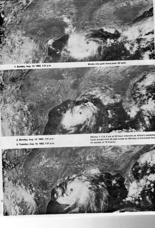
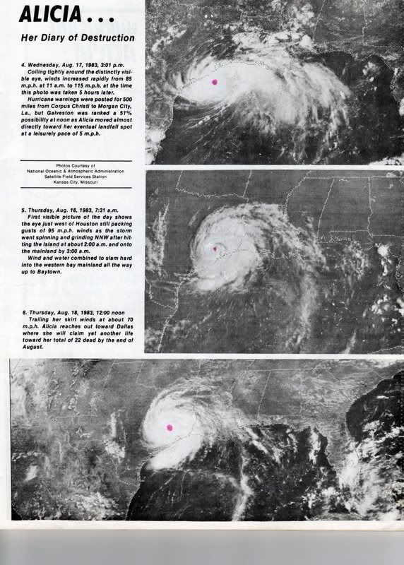
I was at the NHC during Alicia - among other memories of that hurricane, it was a very rare hurricane for it's place of origin:
http://www.nhc.noaa.gov/archive/storm_w ... im/alicia/
also, it formed during a strong El Nino period (there were only 4 named storms during the 1983 Atlantic hurricane season)...
http://www.nhc.noaa.gov/archive/storm_w ... im/alicia/
also, it formed during a strong El Nino period (there were only 4 named storms during the 1983 Atlantic hurricane season)...
0 likes
-
Aric Dunn
- Category 5
- Posts: 21238
- Age: 43
- Joined: Sun Sep 19, 2004 9:58 pm
- Location: Ready for the Chase.
- Contact:
Re: Anyone else see this?
Sorry for the crudeness of my image i just threw it together! but the red arrows are the winds in the area ( my best estimate from buoy reports) the blue circle is an area with relativley light winds.. so the area to watch is that buckle sharper bend in the wind field if we get more convection to maintain it self over the next few days as it sags south more. thre pressure in the area are only about 1013 to 1014 not so low.
again by no means is the image accurate beyond and general overview of the area...

again by no means is the image accurate beyond and general overview of the area...
0 likes
-
srainhoutx

- S2K Supporter
- Posts: 6919
- Age: 68
- Joined: Sun Jan 14, 2007 11:34 am
- Location: Haywood County, NC
- Contact:
Re:
KatDaddy wrote:If Alicia would have had another 12 hours she would have been a strong CAT 3. At least 135MPH or greater. Houston-Galveston were very lucky. 80G100mph was more than enough for me. I cant imagine a CAT 4 or 5.
I agree KatDaddy. I'll never forget driving our engine company pumper to an apartment building collapse and a gust picking up the front of a 50K lbs fire truck and being able to spin the steering wheel will driving to the scene at about 2:00 AM in the morning.
0 likes
Who is online
Users browsing this forum: No registered users and 132 guests