Gulf of Mexico (Is Invest 91L)

This is the general tropical discussion area. Anyone can take their shot at predicting a storms path.

Moderator: S2k Moderators

Forum rules

The posts in this forum are NOT official forecasts and should not be used as such. They are just the opinion of the poster and may or may not be backed by sound meteorological data. They are NOT endorsed by any professional institution or STORM2K. For official information, please refer to products from the National Hurricane Center and National Weather Service.

Help Support Storm2K
Message
Author
Ed Mahmoud

Re: Gulf of Mexico area= 2 PM TWO Posted

#381 Postby Ed Mahmoud » Sat Aug 02, 2008 12:57 pm

weatherrabbit_tx wrote:shades of august 1983 again, hope not. hope its a weaker then alicia....


FWIW, Joe Bastardi wrote 1000 mb, like 1964's Abby, should be roughly the upper limit of what this becomes, and various NAM runs, which have been the extreme outlier, were about that.

But always a good idea to pay attention to local NWS and NHC forecasts, on the very remote chance Bastardi has underforecast this. (His error mode is usually the other way). They seem well aware of the possibility of development.
0 likes   

Bailey1777
S2K Supporter
S2K Supporter
Posts: 962
Joined: Mon Jul 31, 2006 6:23 pm
Location: Houston, Texas

#382 Postby Bailey1777 » Sat Aug 02, 2008 1:01 pm

Strange that the nhc sees this in the medium category for possible developement yet no invest assigned. different agencies I know but......
0 likes   

User avatar
lrak
S2K Supporter
S2K Supporter
Posts: 1770
Age: 58
Joined: Thu Jun 21, 2007 2:48 pm
Location: Corpus Christi, TX

Re: Gulf of Mexico area= 2 PM TWO Posted

#383 Postby lrak » Sat Aug 02, 2008 1:02 pm

Image
0 likes   

RL3AO
Moderator-Pro Met
Moderator-Pro Met
Posts: 16308
Joined: Thu Jun 14, 2007 10:03 pm
Location: NC

Re:

#384 Postby RL3AO » Sat Aug 02, 2008 1:04 pm

Bailey1777 wrote:Strange that the nhc sees this in the medium category for possible developement yet no invest assigned. different agencies I know but......


The NHC is the one that tags invests. They will probably do it later this afternoon.
0 likes   

User avatar
weatherrabbit_tx
Category 1
Category 1
Posts: 270
Joined: Wed Dec 21, 2005 3:13 pm
Location: Kingwood,Tx
Contact:

Re: Gulf of Mexico area= 2 PM TWO Posted

#385 Postby weatherrabbit_tx » Sat Aug 02, 2008 1:08 pm

Ed Mahmoud wrote:
weatherrabbit_tx wrote:shades of august 1983 again, hope not. hope its a weaker then alicia....


FWIW, Joe Bastardi wrote 1000 mb, like 1964's Abby, should be roughly the upper limit of what this becomes, and various NAM runs, which have been the extreme outlier, were about that.

But always a good idea to pay attention to local NWS and NHC forecasts, on the very remote chance Bastardi has underforecast this. (His error mode is usually the other way). They seem well aware of the possibility of development.


abby like storm would wonders for us in the rain department came up the san luis pass area. :D
0 likes   

rockyman
Category 5
Category 5
Posts: 1967
Joined: Thu Jun 26, 2003 12:24 pm
Location: Dauphin Island, AL

#386 Postby rockyman » Sat Aug 02, 2008 1:08 pm

I notice that the circle (oval) is very large over the Gulf system. Perhaps the invest is delayed because the powers-that-be have to decide where to place the center?
0 likes   

Bailey1777
S2K Supporter
S2K Supporter
Posts: 962
Joined: Mon Jul 31, 2006 6:23 pm
Location: Houston, Texas

#387 Postby Bailey1777 » Sat Aug 02, 2008 1:11 pm

Can someone post a link to where the invest pop up when designated.

Thanks
0 likes   

Ed Mahmoud

Re: Gulf of Mexico area= 2 PM TWO Posted

#388 Postby Ed Mahmoud » Sat Aug 02, 2008 1:11 pm

Canadian, which usually also errs on the side of too extreme, also suggests a TD or TS making landfall between GLS and BPT.

UK Met doesn't seem to close a surface low, but shows a low to mid level reflection, with some rain where needed.

Image

12Z NoGAPS shows barely a TD, with light winds, and heaviest rain a bit too far South.

Disclaimer: Amateur and unofficial, and not endorsed by Storm2K web site: Just what the doctor ordered. A weak surface trough, probably a tropical depression, worst case a moderate tropical storm, bringing needed rain. My main worry is system will track too far either North or South, and heaviest rain misses HOU metro. An Alicia, or even an Humberto seems very unlikely at this time, but keep tuned to local NWS and National Hurricane Center updates for latest official forecasts.
0 likes   

User avatar
HouTXmetro
Category 5
Category 5
Posts: 3949
Joined: Sun Jun 13, 2004 6:00 pm
Location: District of Columbia, USA

Re: Gulf of Mexico area= 2 PM TWO Posted

#389 Postby HouTXmetro » Sat Aug 02, 2008 1:12 pm

weatherrabbit_tx wrote:
Ed Mahmoud wrote:
weatherrabbit_tx wrote:shades of august 1983 again, hope not. hope its a weaker then alicia....


FWIW, Joe Bastardi wrote 1000 mb, like 1964's Abby, should be roughly the upper limit of what this becomes, and various NAM runs, which have been the extreme outlier, were about that.

But always a good idea to pay attention to local NWS and NHC forecasts, on the very remote chance Bastardi has underforecast this. (His error mode is usually the other way). They seem well aware of the possibility of development.


abby like storm would wonders for us in the rain department came up the san luis pass area. :D


Is San Luis Pass on the TX/LA border?
0 likes   

RL3AO
Moderator-Pro Met
Moderator-Pro Met
Posts: 16308
Joined: Thu Jun 14, 2007 10:03 pm
Location: NC

Re:

#390 Postby RL3AO » Sat Aug 02, 2008 1:12 pm

Bailey1777 wrote:Can someone post a link to where the invest pop up when designated.

Thanks


Directly from the source: ftp://ftp.tpc.ncep.noaa.gov/atcf/tcweb/invest_al912008.invest

Or you could use the NRL: http://www.nrlmry.navy.mil/tc_pages/tc_home.html
0 likes   

Ed Mahmoud

Re: Gulf of Mexico area= 2 PM TWO Posted

#391 Postby Ed Mahmoud » Sat Aug 02, 2008 1:15 pm

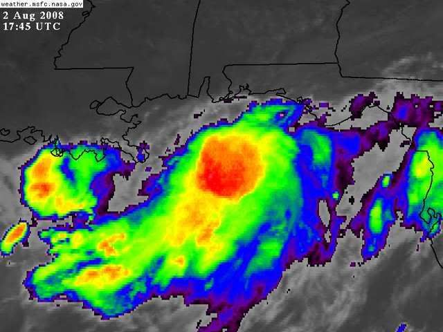
-70ºC cloud tops in thunderstorms, although displaced Southwest of where radar suggests a possible loose circulation center (at whatever level).


Image
0 likes   

User avatar
southerngale
Retired Staff
Retired Staff
Posts: 27418
Joined: Thu Oct 10, 2002 1:27 am
Location: Southeast Texas (Beaumont area)

Re: Gulf of Mexico area= 2 PM TWO Posted

#392 Postby southerngale » Sat Aug 02, 2008 1:16 pm

HouTXmetro wrote:Is San Luis Pass on the TX/LA border?

No, that's Sabine Pass.


Image
0 likes   

User avatar
HouTXmetro
Category 5
Category 5
Posts: 3949
Joined: Sun Jun 13, 2004 6:00 pm
Location: District of Columbia, USA

Re: Gulf of Mexico area= 2 PM TWO Posted

#393 Postby HouTXmetro » Sat Aug 02, 2008 1:17 pm

Ed Mahmoud wrote:Disclaimer: Amateur and unofficial, and not endorsed by Storm2K web site: Just what the doctor ordered. A weak surface trough, probably a tropical depression, worst case a moderate tropical storm, bringing needed rain. My main worry is system will track too far either North or South, and heaviest rain misses HOU metro. An Alicia, or even an Humberto seems very unlikely at this time, but keep tuned to local NWS and National Hurricane Center updates for latest official forecasts.


Don't you think the more Northern Solution is probably likely?

Thanks Southern Gale
0 likes   

Ed Mahmoud

Re: Gulf of Mexico area

#394 Postby Ed Mahmoud » Sat Aug 02, 2008 1:18 pm

San Luis Pass is the Southern end of Galveston Island. On holidays like Labor Day and 4th of July, quickest way away from Jamaica Beach is to drive to Pass, passing signs saying "This Direction is Not a Hurricane Evacuation Route", cross toll bridge, drive along next barrier island, cross bridge to Freeport, and get on Highway (288?) going to Houston.


Edit to add: See map above :uarrow:
0 likes   

RL3AO
Moderator-Pro Met
Moderator-Pro Met
Posts: 16308
Joined: Thu Jun 14, 2007 10:03 pm
Location: NC

Re: Gulf of Mexico area= 2 PM TWO Posted

#395 Postby RL3AO » Sat Aug 02, 2008 1:18 pm

Ed Mahmoud wrote:-70ºC cloud tops in thunderstorms, although displaced Southwest of where radar suggests a possible loose circulation center (at whatever level).


The possible center on radar is at 700mb (10,000ft) or so.
0 likes   

Stratosphere747
Category 5
Category 5
Posts: 3772
Joined: Thu Sep 11, 2003 8:34 pm
Location: Surfside Beach/Freeport Tx
Contact:

Re: Gulf of Mexico area= 2 PM TWO Posted

#396 Postby Stratosphere747 » Sat Aug 02, 2008 1:19 pm

HouTXmetro wrote:
Is San Luis Pass on the TX/LA border?


Figures your an Aggie... :P

Wait, I'm one to!

Hardy group down there, but not the place to be even with a small system....
0 likes   

User avatar
HouTXmetro
Category 5
Category 5
Posts: 3949
Joined: Sun Jun 13, 2004 6:00 pm
Location: District of Columbia, USA

Re: Gulf of Mexico area= 2 PM TWO Posted

#397 Postby HouTXmetro » Sat Aug 02, 2008 1:20 pm

Stratosphere747 wrote:
HouTXmetro wrote:
Is San Luis Pass on the TX/LA border?


Figures your an Aggie... :P

Wait, I'm one to!

Hardy group down there, but not the place to be even with a small system....


Now wait a minute!!
0 likes   

Ed Mahmoud

Re: Gulf of Mexico area= 2 PM TWO Posted

#398 Postby Ed Mahmoud » Sat Aug 02, 2008 1:23 pm

HouTXmetro wrote:
Ed Mahmoud wrote:Disclaimer: Amateur and unofficial, and not endorsed by Storm2K web site: Just what the doctor ordered. A weak surface trough, probably a tropical depression, worst case a moderate tropical storm, bringing needed rain. My main worry is system will track too far either North or South, and heaviest rain misses HOU metro. An Alicia, or even an Humberto seems very unlikely at this time, but keep tuned to local NWS and National Hurricane Center updates for latest official forecasts.


Don't you think the more Northern Solution is probably likely?

Thanks Southern Gale


GFS consistently favors miss to North/East of HOU. Bastardi thinks it is an error due to model giving to much credit to inland 'heat low'. NoGaps and NAM would miss to the South, Canadian is almost perfect for rain. An open wave or poorly organized depression may be preferable to a more organized cyclone, in that organizing cyclones usually concentrate/contract rain when strengthening, before beginning to expand, and this looks unlikely to ever get to the "well organized and beginning to expand" phase.

Unofficial and amateur, of course. I hope WxMan57 returns with his general, and professional, ideas.
0 likes   

User avatar
HURAKAN
Professional-Met
Professional-Met
Posts: 46086
Age: 38
Joined: Thu May 20, 2004 4:34 pm
Location: Key West, FL
Contact:

#399 Postby HURAKAN » Sat Aug 02, 2008 1:25 pm

Image
0 likes   

User avatar
HouTXmetro
Category 5
Category 5
Posts: 3949
Joined: Sun Jun 13, 2004 6:00 pm
Location: District of Columbia, USA

#400 Postby HouTXmetro » Sat Aug 02, 2008 1:27 pm

Wondering if this is the real deal or will it fizzle again.
0 likes   


Return to “Talkin' Tropics”

Who is online

Users browsing this forum: No registered users and 34 guests