Mecklenburg wrote:i don't understand why it's marginally favorable... heck it's the GOM!?!...cycloneye wrote:WONT41 KNHC 031456
DSAAT
SPECIAL TROPICAL DISTURBANCE STATEMENT
NWS TPC/NATIONAL HURRICANE CENTER MIAMI FL
1100 AM EDT SUN AUG 3 2008
SATELLITE IMAGERY AND SURFACE OBSERVATIONS INDICATE THAT A LOW
PRESSURE AREA HAS FORMED IN THE NORTHERN GULF OF MEXICO ABOUT 150
MILES SOUTH OF PENSACOLA FLORIDA. ENVIRONMENTAL CONDITIONS ARE
MARGINALLY FAVORABLE FOR ADDITIONAL DEVELOPMENT...AND A TROPICAL
DEPRESSION COULD FORM DURING THE NEXT DAY OR SO AS THE SYSTEM MOVES
TOWARDS THE WEST. AN AIR FORCE RESERVE HURRICANE HUNTER AIRCRAFT
IS SCHEDULED TO INVESTIGATE THE AREA THIS AFTERNOON. INTERESTS IN
THE NORTHWESTERN GULF OF MEXICO SHOULD MONITOR THE PROGRESS OF THIS
SYSTEM.
$$
FORECASTER BEVEN
http://www.nhc.noaa.gov/text/refresh/MI ... 1456.shtml?
ATL: Tropical Depression Edouard
Moderator: S2k Moderators
Re: ATL: Invest 91L - Gulf of Mexico
Takes more than 80+ degree water form a system to take off
0 likes

Re: ATL: Invest 91L- Gulf of Mexico
Takes more than 80+ degree water form a system to take off
The dry air slot to the north looks like it is filling in and the shear will be weakening.
0 likes
-
cheezyWXguy

- Category 5

- Posts: 6282
- Joined: Mon Feb 13, 2006 12:29 am
- Location: Dallas, TX
Re: ATL: Invest 91L - Gulf of Mexico
jinftl wrote:Takes more than 80+ degree water form a system to take offMecklenburg wrote:i don't understand why it's marginally favorable... heck it's the GOM!?!...cycloneye wrote:WONT41 KNHC 031456
DSAAT
SPECIAL TROPICAL DISTURBANCE STATEMENT
NWS TPC/NATIONAL HURRICANE CENTER MIAMI FL
1100 AM EDT SUN AUG 3 2008
SATELLITE IMAGERY AND SURFACE OBSERVATIONS INDICATE THAT A LOW
PRESSURE AREA HAS FORMED IN THE NORTHERN GULF OF MEXICO ABOUT 150
MILES SOUTH OF PENSACOLA FLORIDA. ENVIRONMENTAL CONDITIONS ARE
MARGINALLY FAVORABLE FOR ADDITIONAL DEVELOPMENT...AND A TROPICAL
DEPRESSION COULD FORM DURING THE NEXT DAY OR SO AS THE SYSTEM MOVES
TOWARDS THE WEST. AN AIR FORCE RESERVE HURRICANE HUNTER AIRCRAFT
IS SCHEDULED TO INVESTIGATE THE AREA THIS AFTERNOON. INTERESTS IN
THE NORTHWESTERN GULF OF MEXICO SHOULD MONITOR THE PROGRESS OF THIS
SYSTEM.
$$
FORECASTER BEVEN
http://www.nhc.noaa.gov/text/refresh/MI ... 1456.shtml?
Which we have. The marginal conditions refer to the 10-15kt of shear on the system
0 likes

-
Stormcenter
- S2K Supporter

- Posts: 6689
- Joined: Wed Sep 03, 2003 11:27 am
- Location: Houston, TX
Re: ATL: Invest 91L- Gulf of Mexico
Let's see it'll take the recon what 10 minutes to get in there.
I think they will find a TD in the formation process. It doesn't look
like much now but later tonight or tomorrow will be a different story. IMO
http://www.ssd.noaa.gov/goes/flt/t2/loop-vis.html
I think they will find a TD in the formation process. It doesn't look
like much now but later tonight or tomorrow will be a different story. IMO
http://www.ssd.noaa.gov/goes/flt/t2/loop-vis.html
0 likes
-
canetracker

- S2K Supporter
- Posts: 751
- Age: 63
- Joined: Wed Jul 27, 2005 8:49 pm
- Location: Suburbia New Orleans...Harahan, LA
Re: ATL: Invest 91L- Gulf of Mexico
Conditions do look to be slowly improving for 91L:
Looks to have some lower level convergence
http://cimss.ssec.wisc.edu/tropic2/real-time/windmain.php?&basin=atlantic&sat=wg8&prod=conv&zoom=&time=
And the shear does look to be decreasing
http://cimss.ssec.wisc.edu/tropic2/real-time/windmain.php?&basin=atlantic&sat=wg8&prod=sht&zoom=&time=
Hopefully you guys in Texas will get some of this
0 likes
-
storms in NC

- S2K Supporter
- Posts: 2338
- Joined: Thu Jul 28, 2005 2:58 pm
- Location: Wallace,NC 40 miles NE of Wilm
- Contact:
-
MiamiensisWx
Re: ATL: Invest 91L- Gulf of Mexico
The following post is NOT an official prognosis.
It is clear that my original prognostication for the possible intensity was likely too aggressive. It appears that convective outflow and subsidence from a MCS entering the Gulf to the NW of the system has been inducing shear and a more stable boundary layer in the vicinity of 91L. Subsidence from the MCS convection has proven to be an inhibiting factor. Note the outflow boundaries emanating from the western semicircle of 91L as a result. When combined with the aforementioned northerly upper level shear (on the east side of the ridge) and pre-existing mid level dry air, the system has suffered in the short term, as evidenced by rising SLP readings per buoy/ASOS stations. However, ascent and low level 850 mb vorticity has remained substantive across the area, which contributed to the formation of a surface low through the overnight hours S of Pensacola, Florida. Originally, I anticipated the effects of ML dry air and the N shear on the system, but I believed it would have been less significant; obviously, verification revealed a different situation.
As the MCS dissipates later today, shear should diminish. Tomorrow, as the ridge moves east and wind vectors shift NE and ENE at all levels, northerly shear should subside. I would not be surprised if the current LLC dissipates and a new one forms further south, where the best ascent and strongest convection may be concentrated. It would also be aligned with the MLC and greatest LL vorticity as well. Note that the current naked LLC is located north of the more unstable boundary layer and greater LL inflow (via stronger thunderstorms) immediately further south. A reformation further south would be typical for similar Gulf systems, as seen in the past. The key for the evolution of this system's future may be tonight's diurnal maximum (DMAX). If a strong initiation/"burst" of new convection can occur in this vicinity, it may finally pave the road toward tropical cyclogenesis for 91L. If it does not occur, the future for this system may be more bleak (weaker). Regardless, I now believe this system may only attain TS intensity (at most) prior to landfall.
My preliminary landfall estimate remains unchanged. My best guess for a strike is the upper portion of the middle Texas coast (Freeport) north to the Galveston area. However, all residents along the middle/upper Texas coastal regions and extreme SW Louisiana should continue to monitor 91L.
0 likes
-
Stormcenter
- S2K Supporter
- Posts: 6689
- Joined: Wed Sep 03, 2003 11:27 am
- Location: Houston, TX
Re: ATL: Invest 91L- Gulf of Mexico
MiamiensisWx wrote:The following post is NOT an official prognosis.
It is clear that my original prognostication for the possible intensity was likely too aggressive. It appears that convective outflow and subsidence from a MCS entering the Gulf to the NW of the system has been inducing shear and a more stable boundary layer in the vicinity of 91L. Subsidence from the MCS convection has proven to be an inhibiting factor. Note the outflow boundaries emanating from the western semicircle of 91L as a result. When combined with the aforementioned northerly upper level shear (on the east side of the ridge) and pre-existing mid level dry air, the system has suffered in the short term, as evidenced by rising SLP readings per buoy/ASOS stations. However, ascent and low level 850 mb vorticity has remained substantive across the area, which contributed to the formation of a surface low through the overnight hours S of Pensacola, Florida. Originally, I anticipated the effects of ML dry air and the N shear on the system, but I believed it would have been less significant; obviously, verification revealed a different situation.
As the MCS dissipates later today, shear should diminish. Tomorrow, as the ridge moves east and wind vectors shift NE and ENE at all levels, northerly shear should subside. I would not be surprised if the current LLC dissipates and a new one forms further south, where the best ascent and strongest convection may be concentrated. It would also be aligned with the MLC and greatest LL vorticity as well. Note that the current naked LLC is located north of the more unstable boundary layer and greater LL inflow (via stronger thunderstorms) immediately further south. A reformation further south would be typical for similar Gulf systems, as seen in the past. The key for the evolution of this system's future may be tonight's diurnal maximum (DMAX). If a strong initiation/"burst" of new convection can occur in this vicinity, it may finally pave the road toward tropical cyclogenesis for 91L. If it does not occur, the future for this system may be more bleak (weaker). Regardless, I now believe this system may only attain TS intensity (at most) prior to landfall.
My preliminary landfall estimate remains unchanged. My best guess for a strike is the upper portion of the middle Texas coast (Freeport) north to the Galveston area. However, all residents along the middle/upper Texas coastal regions and extreme SW Louisiana should continue to monitor 91L.
I think you may be have jumped ship to early on this one especially since it hasn't moved much.
0 likes
Re: ATL: Invest 91L- Gulf of Mexico
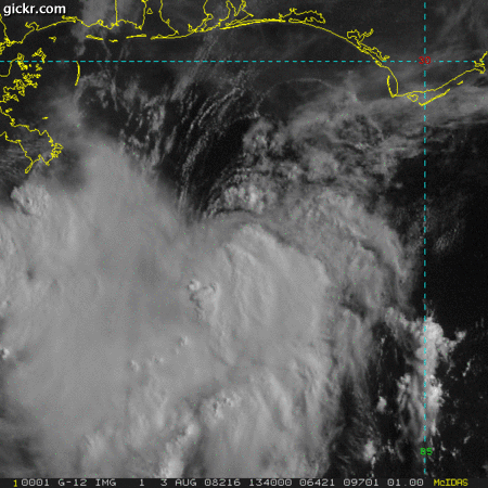
This is already forming in my opinion with an elongated circulation visible on visible. It has the shape.
0 likes


-
MiamiensisWx
Re: ATL: Invest 91L- Gulf of Mexico
MiamiensisWx wrote:The following post is NOT an official prognosis.
It is clear that my original prognostication for the possible intensity was likely too aggressive. It appears that convective outflow and subsidence from a MCS entering the Gulf to the NW of the system has been inducing shear and a more stable boundary layer in the vicinity of 91L. Subsidence from the MCS convection has proven to be an inhibiting factor. Note the outflow boundaries emanating from the western semicircle of 91L as a result. When combined with the aforementioned northerly upper level shear (on the east side of the ridge) and pre-existing mid level dry air, the system has suffered in the short term, as evidenced by rising SLP readings per buoy/ASOS stations. However, ascent and low level 850 mb vorticity has remained substantive across the area, which contributed to the formation of a surface low through the overnight hours S of Pensacola, Florida. Originally, I anticipated the effects of ML dry air and the N shear on the system, but I believed it would have been less significant; obviously, verification revealed a different situation.
As the MCS dissipates later today, shear should diminish. Tomorrow, as the ridge moves east and wind vectors shift NE and ENE at all levels, northerly shear should subside. I would not be surprised if the current LLC dissipates and a new one forms further south, where the best ascent and strongest convection may be concentrated. It would also be aligned with the MLC and greatest LL vorticity as well. Note that the current naked LLC is located north of the more unstable boundary layer and greater LL inflow (via stronger thunderstorms) immediately further south. A reformation further south would be typical for similar Gulf systems, as seen in the past. The key for the evolution of this system's future may be tonight's diurnal maximum (DMAX). If a strong initiation/"burst" of new convection can occur in this vicinity, it may finally pave the road toward tropical cyclogenesis for 91L. If it does not occur, the future for this system may be more bleak (weaker). Regardless, I now believe this system may only attain TS intensity (at most) prior to landfall.
My preliminary landfall estimate remains unchanged. My best guess for a strike is the upper portion of the middle Texas coast (Freeport) north to the Galveston area. However, all residents along the middle/upper Texas coastal regions and extreme SW Louisiana should continue to monitor 91L.
Actually, I'm not sure if the current "LLC" is a true closed low level circulation. Observations and QuikSCAT suggest it is low level rotation, but it's not a closed LLC.
That provides even more support for my hypothesis that the true LLC will develop further south under the convection and MLC...
0 likes

I stated last night that 91L was getting light northerly mid & UL shear. The GFS continues to show that UL conditions should improve later tonight or tomorrow morning, with a narrow UL anticyclone developing right along the northcentral & eastern Gulfcoast, between the ridge to the north and the UL low in the western Caribbean. So this system should start looking better later tonight and tomorrow morning.
0 likes


MiamiensisWx, I suspect that we will see the system eventually try and get better stacked up and the LLC drifting down towards the MLC, given the system seems to be heading that way right now anyway.
Still looks like there is some light shear coming from the north with the convection displaced on the southern side, also the lop-sided look is probably being caused by the inflow coming from the states.
Still looks like there is some light shear coming from the north with the convection displaced on the southern side, also the lop-sided look is probably being caused by the inflow coming from the states.
0 likes
-
JonathanBelles
- Professional-Met

- Posts: 11430
- Age: 35
- Joined: Sat Dec 24, 2005 9:00 pm
- Location: School: Florida State University (Tallahassee, FL) Home: St. Petersburg, Florida
- Contact:
Re: ATL: Invest 91L- Gulf of Mexico
AFD's
Tampa:
OTHERWISE...LOW PRESSURE IN THE NORTH CENTRAL GULF WILL HAVE NO
DIRECT IMPACT ON OUR WX HERE IN WEST CENTRAL FL.
Tallahassee:
ADDITIONALLY...WEAK LOW
PRESSURE PERSISTS OVER THE GULF OF MEXICO ABOUT 150 MILES SOUTH OF
PENSACOLA. 12Z TAE SOUNDING IS QUITE A BIT DRIER THAN 24 HOURS AGO
WITH PWAT AROUND 1.7 INCHES. EXPECT JUST SCATTERED CONVECTION THIS
AFTERNOON ACROSS THE AREA WITH THE BEST CHANCES ALONG THE COAST
CLOSER TO THE GULF LOW.
Mobile:
little to no mention
NOLA:
THE WEAK DISTURBANCE OVER THE GULF IS HAVING A TOUGH TIME OF IT
THIS MORNING AS IT INTERACTS WITH THE UPPER TROUGH AND MID LEVEL
DRY AIR TO ITS NORTH. BUT IT CONTINUES TO FIGHT FOR SURVIVAL.
BETWEEN THESE TWO SYSTEMS(MCS AND DISTURBANCE) THERE IS A CORRIDOR
OF STRONGLY SUBSIDENT AIR FROM THE UPPER LEVELS DOWN TO THE BL.
THIS WILL BE THE REASON FOR THE LOWER CHANCES OF RAIN DURING THE
MORNING HOURS FROM THE PEARL RIVER EASTWARD. AFTER NOON THE MCS
WILL HAVE DECAYED AND THE DISTURBANCE OVER THE GULF...WITH AN
ASSOCIATED INVERTED TROUGH THAT EXTENDS TO THE SHORELINE OF
PENSACOLA...WILL HAVE MOVED FAR ENOUGH WEST TO BEGIN HELPING RAIN
CHANCES INCREASE SLIGHTLY WITH THE HELP OF STRONG HEATING.
...
WILL HAVE TO WATCH FOR ANY FURTHER DEVELOPMENT OF THE SYSTEM OVER
THE GULF SINCE IT WILL HAVE THE ABILITY TO AFFECT POP NUMBERS OVER MUCH
OF THE SOUTH SHORE AREAS.
Lake Charles:
A TROPICAL DISTURBANCE STATEMENT OUT OF TPC NOW SHOWS AN AREA OF
LOW PRESSURE HAS FORMED ABOUT 150 MILES SOUTH OF PENSACOLA.
CONDITIONS ARE MARGINALLY FAVORABLE FOR DEVELOPMENT. AN AIR FORCE
RESERVE ACFT WILL BE INVESTIGATING. TEXAS AND WESTERN LA COASTS
REMAIN IN PLAY FOR SOME KIND OF LANDFALL EARLY TUESDAY. ONLY
CONFIDENCE AT THIS TIME IS FOR INCREASING PRECIP AND TIDES WITH
WINDS TO SCA CRITERIA FOR THE COASTAL WATERS. STAY TUNED.
Houston:
Little to no mention
Corpus Christi:
THE DEEP ANTI-CYCLONIC FLOW AROUND THIS SYSTEM WILL
PUSH THE DISTURBANCE IN THE GULF ON A GENERAL WNW TRACK TOWARD THE
UPPER TEXAS COAST IN THE NEXT 48 HOURS (12Z TUE). NHC IS MONITORING
THIS SYSTEM AND HAS PLACED A 20-50% PROBABILITY THAT T.C. FORMATION
MAY OCCUR IN THE NXT 48 HOURS. MOST OF THE MODEL GUIDANCE KEEPS THIS
SYSTEM JUST TO THE NORTH OF OUR CWA INCLUDING THE GFS/ECMWF AND NOW
THE 06Z NAM.
0 likes
-
Ed Mahmoud
Re: ATL: Invest 91L- Gulf of Mexico
No obs yet on a plane scheduled to depart 11 am CDT, I wonder if the flight was scrubbed, either mechanical issue or lack of interest.
Based on the special statement, I'd guess the latter, if it was scrubbed.
Or maybe just the NHC site isn't updating right.
Edit:
former, not latter...
Based on the special statement, I'd guess the latter, if it was scrubbed.
Or maybe just the NHC site isn't updating right.
Edit:
former, not latter...
0 likes

Re: ATL: Invest 91L- Gulf of Mexico
000
WONT41 KNHC 031456
DSAAT
SPECIAL TROPICAL DISTURBANCE STATEMENT
NWS TPC/NATIONAL HURRICANE CENTER MIAMI FL
1100 AM EDT SUN AUG 3 2008
SATELLITE IMAGERY AND SURFACE OBSERVATIONS INDICATE THAT A LOW
PRESSURE AREA HAS FORMED IN THE NORTHERN GULF OF MEXICO ABOUT 150
MILES SOUTH OF PENSACOLA FLORIDA. ENVIRONMENTAL CONDITIONS ARE
MARGINALLY FAVORABLE FOR ADDITIONAL DEVELOPMENT...AND A TROPICAL
DEPRESSION COULD FORM DURING THE NEXT DAY OR SO AS THE SYSTEM MOVES
TOWARDS THE WEST. AN AIR FORCE RESERVE HURRICANE HUNTER AIRCRAFT
IS SCHEDULED TO INVESTIGATE THE AREA THIS AFTERNOON. INTERESTS IN
THE NORTHWESTERN GULF OF MEXICO SHOULD MONITOR THE PROGRESS OF THIS
SYSTEM.
$$
FORECASTER BEVEN
http://www.nhc.noaa.gov/text/refresh/MI ... 1456.shtml?
0 likes


Who is online
Users browsing this forum: No registered users and 14 guests