Tropical Storm Edouard recon discussion
Moderator: S2k Moderators
-
SouthFloridawx

- S2K Supporter

- Posts: 8346
- Age: 47
- Joined: Tue Jul 26, 2005 1:16 am
- Location: Sarasota, FL
- Contact:
-
HURAKAN

- Professional-Met

- Posts: 46084
- Age: 39
- Joined: Thu May 20, 2004 4:34 pm
- Location: Key West, FL
- Contact:
Code: Select all
126
NOUS42 KNHC 031530 COR
WEATHER RECONNAISSANCE FLIGHTS
CARCAH, NATIONAL HURRICANE CENTER, MIAMI, FL.
1130 AM EDT SUN 03 AUGUST 2008
SUBJECT: TROPICAL CYCLONE PLAN OF THE DAY (TCPOD)
         VALID 04/1100Z TO 05/1100Z AUGUST 2008
         TCPOD NUMBER.....08-064

I.  ATLANTIC REQUIREMENTS
    1. SUSPECT AREA --GULF OF MEXICO
       FLIGHT ONE  --TEAL 70      FLIGHT TWO  --TEAL 71
       A. 04/1800Z-05/0000Z       A. 05/0600Z-1200Z
       B. AFXXX 0305A CYCLONE     B. AFXXX 0405A CYCLONE
       C. 04/1600Z                C. 05/0400Z
       D. 28.3N 91.2W             D. 29.0N 93.5W
       E. 04/1700 TO 05/0000Z     E. 05/0500 TO 1200Z
       F. SFC TO 10,000FT         F. SFC TO 10,000FT
     CORRECTED ITEM D IN FLIGHT ONE, FLIGHT TWO NO CHANGE

    2. SUCCEEDING DAY OUTLOOK: CONTINUE 6 HRLY FIXES.

11. PACIFIC REQUIREMENTS
    1. NEGATIVE RECONNAISSANCE REQUIREMENTS.
    2. SUCCEEDING DAY OUTLOOK.....NEGATIVE.
                     WVW
0 likes
-
MiamiensisWx


Re:
MiamiensisWx wrote:It looks like the winds are shifting (further north) to the E and ENE per latest recon headings...
Is my interpretation correct?
Yep. East wind on the north side of the circulation. We need west and south winds to close it.
0 likes

-
Aric Dunn
- Category 5

- Posts: 21238
- Age: 43
- Joined: Sun Sep 19, 2004 9:58 pm
- Location: Ready for the Chase.
- Contact:
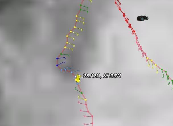
this is the center pass from recon .. very clear evidence of a closed surface low..
193330 2814N 08801W 9767 00270 0074 +228 +210 081014 015 005 003 00
193400 2812N 08801W 9768 00267 0072 +230 +210 062011 013 999 999 03
193430 2811N 08800W 9777 00259 0072 +230 +210 067009 010 004 001 03
193500 2811N 08759W 9764 00271 0072 +229 +210 073009 011 004 001 00
193530 2810N 08757W 9767 00268 0072 +223 +210 076006 009 002 002 00
193600 2809N 08756W 9780 00258 0073 +227 +210 097004 004 000 003 03
193630 2808N 08755W 9762 00274 0074 +224 +210 047003 003 000 003 03
193700 2807N 08755W 9772 00264 0073 +226 +210 336006 008 000 003 00
193730 2805N 08754W 9770 00267 0074 +223 +210 301016 021 012 004 00
193800 2803N 08753W 9775 00265 0076 +222 +210 287023 024 017 003 0
Last edited by Aric Dunn on Sun Aug 03, 2008 2:50 pm, edited 1 time in total.
0 likes
-
El Nino

- Category 1

- Posts: 454
- Age: 48
- Joined: Sun Oct 16, 2005 3:18 pm
- Location: Lima - Miraflores (Peru)
- Contact:
Re: 91L recon discussion
Westely wind and 30 kts according to last RECON series ? (I´m trying to read this for the 1st time)
If yes, we have a TD.
If yes, we have a TD.
0 likes
-
MiamiensisWx
It's Edouard, in my (personal) view. Earlier, data from recon supported ~35 kt 1-min surface winds in SE quadrant. I'm not even including the SFMR readings. We have the corrobating WSW and W winds via reconnaissance and buoy data, which supports a closed LLC in light of all available information. We should see an upgrade to TD/TS status from the NHC today. Regardless, this system is definitely not deepening rapidly, contrary to the assessments from some members.
Last edited by MiamiensisWx on Sun Aug 03, 2008 2:53 pm, edited 1 time in total.
0 likes
-
SouthFloridawx
- S2K Supporter
- Posts: 8346
- Age: 47
- Joined: Tue Jul 26, 2005 1:16 am
- Location: Sarasota, FL
- Contact:
Re: 91L recon discussion
Estimated Surface Wind (30 sec. Avg.)
Using Estimated Reduction Factor 2
6.1 knots (~ 30.0 mph)
44.4 knots (~ 51.1 mph)Tropical Storm
40.7 knots (~ 46.8 mph)Tropical Storm
37.0 knots (~ 42.5 mph)Tropical Storm
These were not suspect areas in the last surface obs.
Using Estimated Reduction Factor 2
6.1 knots (~ 30.0 mph)
44.4 knots (~ 51.1 mph)Tropical Storm
40.7 knots (~ 46.8 mph)Tropical Storm
37.0 knots (~ 42.5 mph)Tropical Storm
These were not suspect areas in the last surface obs.
0 likes
-
hwego7

Re: Re:
RL3AO wrote:pojo wrote:I guess we'll see what this system is going to do during our overnight
If it doesn't strengthen, will you still fly at 200m during night?
we may go higher because of oil rigs.... maybe 300m... our max altitude on TD/LLI is 500m
0 likes

Re: Tropical Depression Five recon discussion
Man, that sounds looooowwwww. Under 1,000 feet the whole time? Or is that the stupidest question ever.
0 likes
Who is online
Users browsing this forum: No registered users and 93 guests