
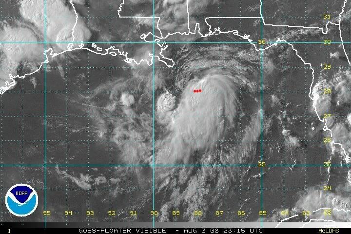
Three VDM fixes
2104z: 28.10N, 87.95W
2222z: 28.07N, 88.07W
2321z: 28.08N, 88.20W
Total movement of 0.02 degrees south, 0.25 degrees west (14.98 nautical miles in 137 minutes)
Vector: 265 @ 6.6 knots (west at 7.6 mph)
ATL: Tropical Depression Edouard
Moderator: S2k Moderators
Re:
even with a continued west motion, the storm could be within 50 miles of the coast tomorrow....it will be interesting to see how that plays out
KWT wrote:Its close but track looks like its pretty much due west IMO so its not getting any closer. There's a big high nearby that should prevent it from going inland over LA though the closeness of land may limit its ability to get rapidly stronger, then again maybe not who knows!
0 likes
-
MiamiensisWx
Latest NHC advisory will certainly raise eyebrows here!
HURRICANE WATCHES OR WARNINGS
MAY BE REQUIRED LATER TONIGHT...
MAXIMUM SUSTAINED WINDS ARE NEAR 50 MPH...85 KM/HR...WITH HIGHER
GUSTS. SOME ADDITIONAL STRENGTHENING IS FORECAST DURING THE NEXT 24
HOURS...AND EDOUARD COULD BE NEARING HURRICANE STRENGTH BEFORE
LANDFALL.
http://www.nhc.noaa.gov/text/refresh/MIATCPAT5+shtml/032348.shtml
Last edited by MiamiensisWx on Sun Aug 03, 2008 6:55 pm, edited 1 time in total.
0 likes
-
Stratosphere747
- Category 5

- Posts: 3772
- Joined: Thu Sep 11, 2003 8:34 pm
- Location: Surfside Beach/Freeport Tx
- Contact:
Re: ATL: Tropical Storm Edouard - Gulf of Mexico
vaffie wrote:Rapid intensification appears to have paused--the pressure has been stable at 1002.7-1002.8 for the past couple hours. Now we wait until DMAX...
There was never "Rapid intensification."
Recon was in there at just the right time to sample the pressure falls of a developing system.
0 likes
Re: Re:
Derek Ortt wrote:not sure this will fire at DMAX
As I said last night, developing GOM systems tend to lose convection at night and refire during the day. This one did just that yesterday
Outa curiousity, what are the reasons? I have noticed, throughout the past ten years of some storms doing that, but not in relation to their locale.
0 likes
-
MGC

- S2K Supporter

- Posts: 5940
- Joined: Sun Mar 23, 2003 9:05 pm
- Location: Pass Christian MS, or what is left.
Re: ATL: Tropical Storm Edouard - Gulf of Mexico
I agree with Dean. The circulation is exposed to the north and north-west of the circulation center. Convection is currently on the south and east sides of the circulation center. And yes, there is some parallax error involved in reading satellite images......MGC
0 likes
-
Dean4Storms
- S2K Supporter
- Posts: 6358
- Age: 63
- Joined: Sun Aug 31, 2003 1:01 pm
- Location: Miramar Bch. FL
Re: ATL: Tropical Storm Edouard - Gulf of Mexico
Steve wrote:>>Dean4Storms, I agree its on the NW side but the tighter LLC is NOT IMO exposed,
It's just coming together. Those bandings are showing up as it gets better organized IMHO. I don't see this as one of those systems where the LLC is racing out front or anything, it's still building on the north and northwestern side as is evidenced by the banding features starting to show up. So I agree with you.
Steve
Exactly, there was no way that LLC was down under the deep convection from what I'm seeing. It is partially exposed, now whether it stays that way is another question.
0 likes

Re:
MiamiensisWx wrote:500-850 mb steering does not support a landfall on the Louisiana Delta region and far southern portions of the state:
http://cimss.ssec.wisc.edu/tropic/real-time/atlantic/winds/wg8dlm2.html
As the system deepens, it will be more influenced by these mid/upper levels (as opposed to 700-850 mb).
Freeport to Galveston, Texas appears to be under the gun.
I am keeping an eye on it for sure!
0 likes

Yep recon pretty much confirms the slight south of west track that has been mentioned, 265 should take it slightly away from land.
MiamiensisWx, yep pretty much the same as before...also worth noting winds have been upped to 50mph as well.
Dean4Storms, lowest pressure recording was just on the broad convection, I suspect convection is firing on the southern side of the LLC, northern side isn't exposed per say as we can't see it but the circulation is exposed on the northern side.
Last edited by KWT on Sun Aug 03, 2008 6:59 pm, edited 1 time in total.
0 likes
-
stevetampa33614
Re: ATL: Tropical Storm Edouard - Gulf of Mexico
Stratosphere747 wrote:vaffie wrote:Rapid intensification appears to have paused--the pressure has been stable at 1002.7-1002.8 for the past couple hours. Now we wait until DMAX...
There was never "Rapid intensification."
Recon was in there at just the right time to sample the pressure falls of a developing system.
Thanks I was trying to say that earlier but everybody told me I was wrong .I dont communicate too well in letters what im thinking.
0 likes
-
cheezyWXguy

- Category 5
- Posts: 6282
- Joined: Mon Feb 13, 2006 12:29 am
- Location: Dallas, TX
Re: ATL: Tropical Storm Edouard - Gulf of Mexico
MGC wrote:I agree with Dean. The circulation is exposed to the north and north-west of the circulation center. Convection is currently on the south and east sides of the circulation center. And yes, there is some parallax error involved in reading satellite images......MGC
I believe derek said a few pages back that recon confirmed that the center was not exposed.
0 likes
Re: ATL: Tropical Storm Edouard - Gulf of Mexico
7:00 PM Advisory 2A
000
WTNT35 KNHC 032348
TCPAT5
BULLETIN
TROPICAL STORM EDOUARD INTERMEDIATE ADVISORY NUMBER 2A
NWS TPC/NATIONAL HURRICANE CENTER MIAMI FL AL052008
700 PM CDT SUN AUG 03 2008
...EDOUARD MOVING SLOWLY WESTWARD...HURRICANE WATCHES OR WARNINGS
MAY BE REQUIRED LATER TONIGHT...
A TROPICAL STORM WARNING REMAINS IN EFFECT FOR THE LOUISIANA COAST
FROM THE MOUTH OF THE MISSISSIPPI RIVER WESTWARD TO INTRACOASTAL
CITY. A TROPICAL STORM WARNING MEANS THAT TROPICAL STORM CONDITIONS
ARE EXPECTED WITHIN THE WARNING AREA WITHIN THE NEXT 24 HOURS.
A TROPICAL STORM WATCH REMAINS IN EFFECT WEST OF INTRACOASTAL CITY
TO PORT OCONNOR TEXAS. A TROPICAL STORM WATCH MEANS THAT TROPICAL
STORM CONDITIONS ARE POSSIBLE WITHIN THE WATCH AREA...GENERALLY
WITHIN 36 HOURS.
FOR STORM INFORMATION SPECIFIC TO YOUR AREA...INCLUDING POSSIBLE
INLAND WATCHES AND WARNINGS...PLEASE MONITOR PRODUCTS ISSUED
BY YOUR LOCAL WEATHER OFFICE.
AT 700 PM CDT...0000Z...THE CENTER OF TROPICAL STORM EDOUARD WAS
LOCATED NEAR LATITUDE 28.1 NORTH...LONGITUDE 88.2 WEST OR ABOUT 90
MILES...145 KM...SOUTHEAST OF THE MOUTH OF THE MISSISSIPPI RIVER AND
ABOUT 415 MILES...670 KM...EAST-SOUTHEAST OF GALVESTON TEXAS.
EDOUARD IS MOVING TOWARD THE WEST NEAR 4 MPH...6 KM/HR...AND
A GENERAL MOTION TOWARD THE WEST OR WEST-NORTHWEST IS FORECAST
DURING THE NEXT COUPLE OF DAYS. ON THE FORECAST TRACK...THE CENTER
OF THE CYCLONE WILL MOVE PARALLEL TO THE LOUISIANA COAST TONIGHT
AND MONDAY...AND BE VERY NEAR THE COAST OF SOUTHWESTERN LOUISIANA OR
THE UPPER TEXAS COAST ON TUESDAY.
MAXIMUM SUSTAINED WINDS ARE NEAR 50 MPH...85 KM/HR...WITH HIGHER
GUSTS. SOME ADDITIONAL STRENGTHENING IS FORECAST DURING THE NEXT 24
HOURS...AND EDOUARD COULD BE NEARING HURRICANE STRENGTH BEFORE
LANDFALL.
TROPICAL STORM FORCE WINDS EXTEND OUTWARD UP TO 35 MILES...55 KM
FROM THE CENTER.
THE LATEST MINIMUM CENTRAL PRESSURE REPORTED BY RECONNAISSANCE
AIRCRAFT WAS 1002 MB...29.59 INCHES.
STORM SURGE OF 2 TO 4 FT ABOVE NORMAL TIDE LEVELS CAN BE EXPECTED IN
THE WARNING AREA IN AREAS OF ONSHORE FLOW.
EDOUARD IS EXPECTED TO PRODUCE TOTAL RAIN ACCUMULATIONS OF 1 TO 2
INCHES ALONG THE THE LOUISIANA COAST WITH POSSIBLE ISOLATED MAXIMUM
AMOUNTS OF 3 INCHES. ONCE THE SYSTEM MOVES TO THE UPPER TEXAS
COAST...TOTAL RAIN ACCUMULATIONS OF 2 TO 4 INCHES WITH ISOLATED
MAXIMUM AMOUNTS OF 6 INCHES ARE POSSIBLE OVER SOUTHEASTERN TEXAS.
REPEATING THE 700 PM CDT POSITION...28.1 N...88.2 W. MOVEMENT
TOWARD...WEST NEAR 4 MPH. MAXIMUM SUSTAINED WINDS...50 MPH.
MINIMUM CENTRAL PRESSURE...1002 MB.
THE NEXT ADVISORY WILL BE ISSUED BY THE NATIONAL
HURRICANE CENTER AT 1000 PM CDT.
$$
FORECASTER FRANKLIN
http://www.nhc.noaa.gov/text/refresh/MI ... 2348.shtml
It has slowed down somewhat.
0 likes
-
Dean4Storms
- S2K Supporter
- Posts: 6358
- Age: 63
- Joined: Sun Aug 31, 2003 1:01 pm
- Location: Miramar Bch. FL
One thing to ponder, if the DMAX doesn't occur tonight might the center become more exposed? It is on the very NW quadrant of the convection so instead of out racing the convection it could just lose its convection and become more exposed overnight although that will get hard to tell once it gets dark.
0 likes
-
Stormcenter
- S2K Supporter
- Posts: 6689
- Joined: Wed Sep 03, 2003 11:27 am
- Location: Houston, TX
Re: ATL: Tropical Storm Edouard - Gulf of Mexico
The key thing to note from the latest advisory in addition to the reference to possible Hurricane watches and warnings later tonight is the forward speed of only 4 mph. This confirms what the satellite loops show...he isn't going anywhere fast and that's not good anyway you look at it.
0 likes
-
srainhoutx

- S2K Supporter
- Posts: 6919
- Age: 68
- Joined: Sun Jan 14, 2007 11:34 am
- Location: Haywood County, NC
- Contact:
Re: ATL: Tropical Storm Edouard - Gulf of Mexico
Stratosphere747 wrote:vaffie wrote:Rapid intensification appears to have paused--the pressure has been stable at 1002.7-1002.8 for the past couple hours. Now we wait until DMAX...
There was never "Rapid intensification."
Recon was in there at just the right time to sample the pressure falls of a developing system.
Totally agree.
0 likes
-
lrak

- S2K Supporter
- Posts: 1770
- Age: 59
- Joined: Thu Jun 21, 2007 2:48 pm
- Location: Corpus Christi, TX
Re: ATL: Tropical Storm Edouard - Gulf of Mexico
It really looks like the center is trying to jump SW. The last visible shows the upper part of the storm's LL bands kind of give out while the bottom SW section cranks up?
0 likes
-
stevetampa33614
Re: ATL: Tropical Storm Edouard - Gulf of Mexico
Some people see Cat 5's out of cumulus coulds. Rapid Intensification, is not happening.
0 likes


Re: ATL: Tropical Storm Edouard - Gulf of Mexico
18Z GFDL still predicting cat 1 hurricane (991.6 mb), 71.3 knots, on eastern border of Galveston Bay. Initialized too high (1008 mb).
http://moe.met.fsu.edu/cgi-bin/gfdltc2. ... =Animation
18Z HWRF begins at 1009 mb, strengthens it to 998 mb and then back up to 1000 just prior to landfall on western border of Galveston Bay. Highest windspeed 38.5 knots ever reached (which it has already surpassed).
http://moe.met.fsu.edu/cgi-bin/hwrftc2. ... =Animation
0 likes
Who is online
Users browsing this forum: No registered users and 25 guests