
http://radar.weather.gov/radar.php?prod ... IX&loop=no
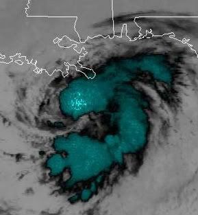
the mid level center of Edouard is very evident on this loop, and that curved band has persisted for over an hour. The LLC is not quite stacked with the MLC, but its getting close.
ATL: Tropical Depression Edouard
Moderator: S2k Moderators
-
Matt-hurricanewatcher
Re: ATL: Tropical Storm Edouard - Gulf of Mexico
This storm is about as big as Humberto. The wind field is very small and makes most tropical storms seem huge.
0 likes
-
Ed Mahmoud
Re: ATL: Tropical Storm Edouard - Gulf of Mexico
I'm glad for the small weakening/strengthening sequence overnight, which resulted in no net change in strength over night.
A tropical storm will do more good than harm around here, away from the coast. A hurricane, not so good.
A tropical storm will do more good than harm around here, away from the coast. A hurricane, not so good.
0 likes
-
sphelps8681
- Category 2

- Posts: 785
- Joined: Thu Aug 16, 2007 5:37 pm
- Location: Somewhere over the rainbow
Re: ATL: Tropical Storm Edouard - Gulf of Mexico
Wonder what city Jim C from TWC will show up at.
0 likes

It is looking better, looks like there should be some rains coming into the extreme south LA as well from this.
Nice deep convection over the eastern side of the LLC now its just a case of waiting to see if it can fully wrap itself around, however it won't be till we see Vis. imagery that we see really just how the the system is going.
Nice deep convection over the eastern side of the LLC now its just a case of waiting to see if it can fully wrap itself around, however it won't be till we see Vis. imagery that we see really just how the the system is going.
0 likes
-
Ed Mahmoud
Re: ATL: Tropical Storm Edouard - Gulf of Mexico
sphelps8681 wrote:Wonder what city Jim C from TWC will show up at.
I think Stephanie Abrams doing a live shot from the Flagship Hotel fishing pier, where I have caught a couple of edible fish, and numerous hardheads, would rock.
Not sure she and her crew would want to be there in a strong TS/minimal hurricane, but it would be great TV.
I wonder if anyone has old stock footage of the wall of the Flagship peeling off during Alicia.
They did fix the hotel. Good as new.
0 likes
-
Bailey1777
- S2K Supporter

- Posts: 962
- Joined: Mon Jul 31, 2006 6:23 pm
- Location: Houston, Texas
-
HurricaneHunter914
- Category 5

- Posts: 4439
- Age: 32
- Joined: Fri Mar 10, 2006 7:36 pm
- Location: College Station, TX
-
Bailey1777
- S2K Supporter
- Posts: 962
- Joined: Mon Jul 31, 2006 6:23 pm
- Location: Houston, Texas
-
Matt-hurricanewatcher
Re:
Bailey1777 wrote:Now that Ed seems on his way are ther any inhibiting factors between here and the coast, or is it just a matter of how strong how quick?
How much upper or mid level shear...I believe both are going to become pretty favorable, but that can change very fast.
Mid level dry air and dry air in general from off the land. But if it forms a strong innercore and the wind shear is weak that should not effect it to much over the next 24 hours.
Tchp don't support a cat5 south of 28 north, a small area on the TCHP map north of that near the coast does, but the waters might not be deep enough if it is moving slow. While a stripe of only low end cat4 waters from that point to around Brownsville texas. But anyways don't expect anything anywhere close to that. Not enough time to form and the mid level shear should never become super favorable for it.
Last edited by Matt-hurricanewatcher on Mon Aug 04, 2008 6:44 am, edited 1 time in total.
0 likes
-
HurricaneHunter914
- Category 5
- Posts: 4439
- Age: 32
- Joined: Fri Mar 10, 2006 7:36 pm
- Location: College Station, TX

-
HouTXmetro

- Category 5
- Posts: 3949
- Joined: Sun Jun 13, 2004 6:00 pm
- Location: District of Columbia, USA
-
HURAKAN

- Professional-Met

- Posts: 46084
- Age: 39
- Joined: Thu May 20, 2004 4:34 pm
- Location: Key West, FL
- Contact:
Loop: http://www.ssd.noaa.gov/goes/flt/t2/loop-ir2.html
The loop shows the exposed LLC moving S of due W and now being covered by the strong convection.
The loop shows the exposed LLC moving S of due W and now being covered by the strong convection.
0 likes
This still has enough time to become a hurricane if it get its act together in the next 9hrs or so and there are certainly hints of that occuring as well.
Once the shear eases up the dry air intrusion should relax somewhat more.
I wouldn't put a huge amountt of faith in the shear maps, they missed the shear that hit the system about 6-9hrs ago totally.
Once the shear eases up the dry air intrusion should relax somewhat more.
I wouldn't put a huge amountt of faith in the shear maps, they missed the shear that hit the system about 6-9hrs ago totally.
Last edited by KWT on Mon Aug 04, 2008 6:50 am, edited 1 time in total.
0 likes
-
Smurfwicked
- Tropical Storm

- Posts: 164
- Age: 41
- Joined: Mon Sep 03, 2007 7:47 pm
- Location: SETX
Re: ATL: Tropical Storm Edouard - Gulf of Mexico
Our local met James Brown channel 6 just said looks like Galveston Bay by late Tues. night strong TS or minimal hurricane but also said that could change and that it shows signs of intensification now.
He also pointed out that this will be coming from a different direction than Humberto meaning we'll be getting more of the brunt of it all being in the NE quad longer as it passes before landfall.
For anybody local who didn't watch channel 6 news this morning. They also said they're doing 30 minute coverage on Time Warner cable channel 10 at 7am Central.
0 likes

-
crazycajuncane

- S2K Supporter
- Posts: 1097
- Joined: Sun Aug 15, 2004 2:51 pm
- Location: Lafayette, Louisiana
- Contact:
Re:
HURAKAN wrote:Loop: http://www.ssd.noaa.gov/goes/flt/t2/loop-ir2.html
The loop shows the exposed LLC moving S of due W and now being covered by the strong convection.
Looking much better this morning. The local news is covering this on a serious note. This is a good test run. They were just talking about Lili in 02 that was coming in as a Cat 4 and ended up hitting the coast as a Cat 1. We were really spared for that storm.
0 likes
-
HouTXmetro
- Category 5
- Posts: 3949
- Joined: Sun Jun 13, 2004 6:00 pm
- Location: District of Columbia, USA
Is it just me or did he not move much last night? Looks to be in the same spot when I went to bed.
Edit, I forgot to refresh my radar. Embarassed.
Edit, I forgot to refresh my radar. Embarassed.
Last edited by HouTXmetro on Mon Aug 04, 2008 6:52 am, edited 1 time in total.
0 likes
Who is online
Users browsing this forum: No registered users and 102 guests