ATL: Tropical Depression Edouard
Moderator: S2k Moderators
-
Ivanhater

- Storm2k Moderator

- Posts: 11221
- Age: 39
- Joined: Fri Jul 01, 2005 8:25 am
- Location: Pensacola
Re: ATL: Tropical Storm Edouard - Gulf of Mexico
With the blow up over the center, not surprising pressure is dropping, winds will increase in the next couple of hours with the lapse time between pressure drop and wind speed..

0 likes
-
Derek Ortt
-
HURAKAN

- Professional-Met

- Posts: 46084
- Age: 39
- Joined: Thu May 20, 2004 4:34 pm
- Location: Key West, FL
- Contact:
Remember to vote for July's "Storm of the Month." Make your opinion count!
Link: viewtopic.php?f=59&t=102308
Back to Edouard:

Link: viewtopic.php?f=59&t=102308
Back to Edouard:
0 likes
-
hwego7
Re:
RADAR BANDING CONSISTENT WITH FL CENTER FIX POSITION. BAND CONVECTION HAS REDUCED, BUT ORGANIZATION HAS IMPROVED.Derek Ortt wrote:This does NOT have that much better of a sat signature from earlier today
the deep convection is still quite disorganized and is showing no signs of organizing.
Recon is reporting the opposite, they are saying in the VDM that the organization has actually improved.
0 likes
-
Ivanhater
- Storm2k Moderator
- Posts: 11221
- Age: 39
- Joined: Fri Jul 01, 2005 8:25 am
- Location: Pensacola
Re:
Derek Ortt wrote:This does NOT have that much better of a sat signature from earlier today
the deep convection is still quite disorganized and is showing no signs of organizing.
I have to disagree Derek, for the first time, convection is able to lift over the LLC, which is slowly tightening the center , with pressure gradually dropping, this is organizing...
0 likes
-
Cape Verde

- Category 2

- Posts: 564
- Age: 70
- Joined: Tue Aug 31, 2004 5:53 pm
- Location: Houston area
Re: ATL: Tropical Storm Edouard - Gulf of Mexico
It certainly looks better than it did this morning. Scroll back on this thread to about 7 am CDT and it's quite obvious.
0 likes


Re: ATL: Tropical Storm Edouard - Gulf of Mexico
Dr. Lyons on TWC, just said he thinks the pressure drop is partly related to the dinural pressure trend in the tropics. But he is concerned that is slowed down. It gives up more to time "spin up" before landfall.
0 likes
-
Wx_Warrior
- Category 5

- Posts: 2718
- Joined: Thu Aug 03, 2006 3:58 pm
- Location: Beaumont, TX
Re: ATL: Tropical Storm Edouard - Gulf of Mexico
I dont jump on too many pro mets...A few I've questioned but they know way more than the average poster.
Instead of "getting his act together or here he comes RI", Eddie has added some width/length, cloud coverage.
Instead of "getting his act together or here he comes RI", Eddie has added some width/length, cloud coverage.
0 likes
-
cycloneye

- Admin

- Posts: 149310
- Age: 69
- Joined: Thu Oct 10, 2002 10:54 am
- Location: San Juan, Puerto Rico
Re: ATL: Tropical Storm Edouard - Gulf of Mexico
A remark from the latest VDM.
RADAR BANDING CONSISTENT WITH FL CENTER FIX POSITION. BAND CONVECTION HAS REDUCED, BUT ORGANIZATION HAS IMPROVED.
RADAR BANDING CONSISTENT WITH FL CENTER FIX POSITION. BAND CONVECTION HAS REDUCED, BUT ORGANIZATION HAS IMPROVED.
0 likes
-
SouthFloridawx

- S2K Supporter

- Posts: 8346
- Age: 47
- Joined: Tue Jul 26, 2005 1:16 am
- Location: Sarasota, FL
- Contact:
Re: ATL: Tropical Storm Edouard - Gulf of Mexico
Thunder44 wrote:Dr. Lyons on TWC, just said he thinks the pressure drop is partly related to the dinural pressure trend in the tropics. But he is concerned that is slowed down. It gives up more to time "spin up" before landfall.
Slowing down is all the more reason why I think it's going to head more towards LA, than Texas.
0 likes
-
Matt-hurricanewatcher
Re: ATL: Tropical Storm Edouard - Gulf of Mexico
A little off topic but what Edouard do you feel was more impressive the 2002 one or this one. I feel the 2002 one had deeper convection for time over the LLC, but this one has better banding and less shear overall to deal with.
Anyways this is much better then it was earlier today. You have 'great' outflow over the east and southeast quads. With 20 percent "eye" feature.
Anyways this is much better then it was earlier today. You have 'great' outflow over the east and southeast quads. With 20 percent "eye" feature.
0 likes


Re: ATL: Tropical Storm Edouard - Gulf of Mexico
KWT wrote:Very interesting Hurakan, I suppose that may mean either two things, either recon missed the true center or it has jogged SSW in the last hour or so, either one is interesting to note
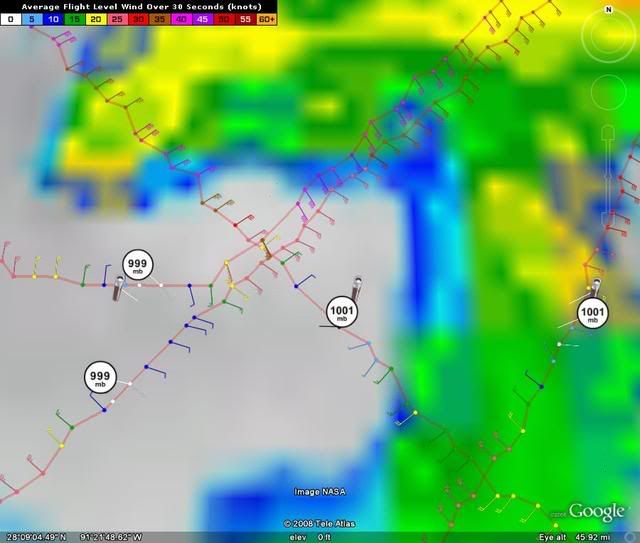
Actually the top 999 reading was the last pass through....
Last edited by kurtpage on Mon Aug 04, 2008 6:02 pm, edited 1 time in total.
0 likes
-
Category 5

- Category 5
- Posts: 10074
- Age: 36
- Joined: Sun Feb 11, 2007 10:00 pm
- Location: New Brunswick, NJ
- Contact:
Re: Re:
americanrebel wrote:Aric Dunn wrote:so far 999mb ..
Come on drop another 4 mb. LOL
I know I have dry humor.
A dry post more like.
Anyway, if you look on the last frame you can see the latest flare up.
0 likes

Re:
KWT wrote:Very interesting Hurakan, I suppose that may mean either two things, either recon missed the true center or it has jogged SSW in the last hour or so, either one is interesting to note
Other way around. The most northern one is the most recent. It was a bad VDM because it hasn't jogged NNE.
0 likes
-
HURAKAN
- Professional-Met
- Posts: 46084
- Age: 39
- Joined: Thu May 20, 2004 4:34 pm
- Location: Key West, FL
- Contact:
Re: Re:
RL3AO wrote:KWT wrote:Very interesting Hurakan, I suppose that may mean either two things, either recon missed the true center or it has jogged SSW in the last hour or so, either one is interesting to note
Other way around. The most northern one is the most recent. It was a bad VDM because it hasn't jogged NNE.

0 likes
Who is online
Users browsing this forum: No registered users and 53 guests