ATL: Tropical Depression Edouard

Moderator: S2k Moderators

Message
Author
Stormcenter
S2K Supporter
S2K Supporter
Posts: 6684
Joined: Wed Sep 03, 2003 11:27 am
Location: Houston, TX

Re:

#2521 Postby Stormcenter » Mon Aug 04, 2008 11:09 pm

Sean in New Orleans wrote:It's getting pretty close to shore...it may come in around Sabine Pass, or at least the "center," may start to move over land in this vicinity.


Yes that is what I'm seeing but I'm not an expert.
0 likes   

User avatar
funster
Category 3
Category 3
Posts: 816
Joined: Sat Dec 29, 2007 4:27 pm
Location: North Dallas

Re: ATL: Tropical Storm Edouard - Gulf of Mexico

#2522 Postby funster » Mon Aug 04, 2008 11:09 pm

LSU2001 wrote:Image
The burst does appear to be quite impressive.
Tim


Ed's a tiny dude but the tiny ones can really tighten up at the last minute.
0 likes   

fasterdisaster
Category 5
Category 5
Posts: 1868
Joined: Mon Sep 19, 2005 4:41 pm
Location: Miami, Florida

Re:

#2523 Postby fasterdisaster » Mon Aug 04, 2008 11:09 pm

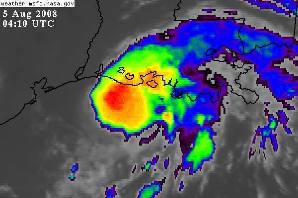
Sean in New Orleans wrote:It's a little system....very small.


It wouldn't be that small if there wasn't absolutely nothing on the southern half.
0 likes   

User avatar
crazycajuncane
S2K Supporter
S2K Supporter
Posts: 1097
Joined: Sun Aug 15, 2004 2:51 pm
Location: Lafayette, Louisiana
Contact:

Re: ATL: Tropical Storm Edouard - Gulf of Mexico

#2524 Postby crazycajuncane » Mon Aug 04, 2008 11:11 pm

LaBreeze wrote:Yes, crazycajuncane, the breeze is nice. You should feel the gusts we're starting to get down here in Vermilion. Light rain starting to fall as well and very gusty.


Looks like Ed's giving ya'll a free show! It's pretty windy here. Really picked up in the last half hour. The outer bands want to touch so bad.
0 likes   

Sanibel
Category 5
Category 5
Posts: 10375
Joined: Mon Aug 30, 2004 11:06 pm
Location: Offshore SW Florida

Re: ATL: Tropical Storm Edouard - Gulf of Mexico

#2525 Postby Sanibel » Mon Aug 04, 2008 11:12 pm

It wouldn't be that small if there wasn't absolutely nothing on the southern half.


Which is exactly why it doesn't have good structure.
0 likes   

Stormcenter
S2K Supporter
S2K Supporter
Posts: 6684
Joined: Wed Sep 03, 2003 11:27 am
Location: Houston, TX

#2526 Postby Stormcenter » Mon Aug 04, 2008 11:15 pm

It's amazing how we all see something different when comes
to what direction Eddie is moving in. I've seen post saying he was moving W,WSW,WNW,NW,N and yes even NE motion in this evening's posts.
What I do see is he is a lot closer to the coast of LA. then I anticipated him being.
0 likes   

User avatar
crazycajuncane
S2K Supporter
S2K Supporter
Posts: 1097
Joined: Sun Aug 15, 2004 2:51 pm
Location: Lafayette, Louisiana
Contact:

Re:

#2527 Postby crazycajuncane » Mon Aug 04, 2008 11:17 pm

Stormcenter wrote:It's amazing how we all see something different when comes
to what direction Eddie is moving in. I've seen post saying he was moving W,WSW,WNW,NW,N and yes even NE motion in this evening's posts.
What I do see is he is a lot closer to the coast of LA. then I anticipated him being.


It's all about perception! Maybe at one point in time it moved all those directions (minus NE).

Hey but its all fun! We're all enjoying this crazy little storm and once it's over we may be done for the season!
0 likes   

User avatar
Extremeweatherguy
Category 5
Category 5
Posts: 11095
Joined: Mon Oct 10, 2005 8:13 pm
Location: Florida

#2528 Postby Extremeweatherguy » Mon Aug 04, 2008 11:17 pm

Here is a closer look at where the center probably is..

http://farm4.static.flickr.com/3029/273 ... 96.jpg?v=0

If the WNW motion continues overnight, then this will come ashore very close to the 10pm NHC track (give or take 20 miles north or south). The heaviest bands of wind/rain will be near and north of where this makes landfall though, with lesser winds and rains to the south UNLESS more southern convection can fire overnight. Definitely an interesting day ahead from the northern half of Galveston Island all the way eastward to near Cameron, LA.

The posts in this forum are NOT official forecast and should not be used as such. They are just the opinion of the poster and may or may not be backed by sound meteorological data. They are NOT endorsed by any professional institution or storm2k.org. For official information, please refer to the NHC and NWS products.
Last edited by Extremeweatherguy on Mon Aug 04, 2008 11:21 pm, edited 2 times in total.
0 likes   

CrazyC83
Professional-Met
Professional-Met
Posts: 34002
Joined: Tue Mar 07, 2006 11:57 pm
Location: Deep South, for the first time!

#2529 Postby CrazyC83 » Mon Aug 04, 2008 11:18 pm

MESOSCALE DISCUSSION 2030
NWS STORM PREDICTION CENTER NORMAN OK
1102 PM CDT MON AUG 04 2008

AREAS AFFECTED...PORTIONS COASTAL SRN LA -- TS EDOUARD TORNADO
POTENTIAL.

CONCERNING...SEVERE POTENTIAL...WATCH POSSIBLE

VALID 050402Z - 050630Z

TORNADO POTENTIAL MAY DEVELOP ACROSS IMMEDIATE COASTAL AREAS DURING
NEXT SEVERAL HOURS IN STEP WITH WNWWD JOG OF STORM CENTER. AS A
RESULT...SMALL ENVELOPE OF FAVORABLE WINDS JUST ABOVE SFC -- AND
THEREFORE OF LOW-LEVEL SHEAR SUPPORTING SUPERCELLS...IS PENETRATING
INLAND. TORNADO THREAT APPEARS MRGL ATTM BUT IS INCREASING...AND WW
MAY BE REQUIRED OVERNIGHT.

LIX VWP IS TOO FAR FROM CENTER TO SAMPLE THESE WINDS AND SHOULD
REMAIN SO GIVEN FCST TRACK OF SYSTEM...BUT INDICATES HODOGRAPH
CURVATURE THAT SHOULD BE PRESENT WITH LARGER SPEEDS INVOF CENTRAL LA
COAST. LCH/POE VWP SAMPLING WILL REMAIN DISTANT AND IN NW QUADRANT
FOR SEVERAL MORE HOURS. HOWEVER...MODIFIED HODOGRAPHS SUGGEST 0-1
KM SRH 100-200 J/KG SPREADING INLAND. MAIN LIMITING FACTOR BEFORE
NOW -- OTHER THAN RELATIVELY SMALL SIZE OF WINDS -- HAS BEN LACK OF
DISCRETE/CELLULAR CONVECTIVE STRUCTURE. HOWEVER..REFLECTIVITY
ANIMATIONS SUGGEST ISOLATED SUPERCELL DEVELOPING JUST OFFSHORE
TERREBONNE PARISH AS OF 330Z...MOVING NWWD TOWARD ATCHAFALAYA BAY
AND POINT AU FER REGION. OTHER DISCRETE/ROTATING CELLS MAY FORM IN
SEWD EXTENSION OF SAME CONVERGENCE BAND...OVER MIDDLE/OUTER SECTORS
OF NERN QUADRANT OF CIRCULATION. ALTHOUGH AIR MASS INLAND HAS BEGUN
DIABATICALLY COOLING WITH INCREASING SBCINH...HIGH THETAE BOUNDARY
LAYER PROFILES NEAR COAST SUGGEST EFFECTIVE LIFTED PARCELS WILL
REMAIN ROOTED AT SFC...WITH AT LEAST MRGL BUOYANCY TO SUPPORT
CONTINUED CONVECTION IN ADDITION TO SPIRAL CONVERGENCE LINES.
OVERALL SUPERCELLULAR COVERAGE SHOULD REMAIN ISOLATED GIVEN LIMITED
BREADTH OF FAVORABLE KINEMATIC PROFILES.

REF NHC ADVISORIES -- E.G. WMO HEADER WTNT25 KNHC -- FOR LATEST
TROPICAL WATCH/WARNING AND TRACK/INTENSITY FCST DETAILS ON EDOUARD.

..EDWARDS.. 08/05/2008


ATTN...WFO...LIX...LCH...

29729302 30239277 29919124 29829055 29319029 29059029
29019036 29109059 29049068 29049096 29119088 29179098
29229122 29329131 29429119 29519137 29539152 29639161
29739166 29709184 29569171 29479182 29579205 29549225
29579262
0 likes   

RL3AO
Moderator-Pro Met
Moderator-Pro Met
Posts: 16308
Joined: Thu Jun 14, 2007 10:03 pm
Location: NC

Re: ATL: Tropical Storm Edouard - Gulf of Mexico

#2530 Postby RL3AO » Mon Aug 04, 2008 11:20 pm

Image
0 likes   

User avatar
HURAKAN
Professional-Met
Professional-Met
Posts: 46086
Age: 38
Joined: Thu May 20, 2004 4:34 pm
Location: Key West, FL
Contact:

#2531 Postby HURAKAN » Mon Aug 04, 2008 11:23 pm

Image

Very strong convection.
0 likes   

User avatar
HouTXmetro
Category 5
Category 5
Posts: 3949
Joined: Sun Jun 13, 2004 6:00 pm
Location: District of Columbia, USA

#2532 Postby HouTXmetro » Mon Aug 04, 2008 11:24 pm

wondering what kind of winds they will find in the Heavy convection?
Last edited by HouTXmetro on Mon Aug 04, 2008 11:27 pm, edited 1 time in total.
0 likes   

TTheriot1975
Tropical Storm
Tropical Storm
Posts: 113
Age: 50
Joined: Thu Aug 16, 2007 8:12 pm
Location: Southeast Texas

#2533 Postby TTheriot1975 » Mon Aug 04, 2008 11:26 pm

OK...where is the recon flight now...I am not good at all about reading all those lines with numbers in the recon thread. What are you experienced ones finding out?
0 likes   

RL3AO
Moderator-Pro Met
Moderator-Pro Met
Posts: 16308
Joined: Thu Jun 14, 2007 10:03 pm
Location: NC

Re:

#2534 Postby RL3AO » Mon Aug 04, 2008 11:27 pm

TTheriot1975 wrote:OK...where is the recon flight now...I am not good at all about reading all those lines with numbers in the recon thread. What are you experienced ones finding out?


Do you have Google Earth?

http://tropicalatlantic.com/recon/ge/Recon_Data_for_the_Atlantic_Basin.kmz
0 likes   

TTheriot1975
Tropical Storm
Tropical Storm
Posts: 113
Age: 50
Joined: Thu Aug 16, 2007 8:12 pm
Location: Southeast Texas

#2535 Postby TTheriot1975 » Mon Aug 04, 2008 11:28 pm

Looking at the convection...it is strengthening right now...and my area will be on the dirty side of whatever it will be tonight to tomorrow morning...just picked up all the stuff in my backyard...thank goodness we have good lighting back there.
0 likes   

physicx07
Tropical Storm
Tropical Storm
Posts: 215
Joined: Wed May 28, 2008 7:46 am
Location: Miami

Re:

#2536 Postby physicx07 » Mon Aug 04, 2008 11:30 pm

They are sampling pretty far to the east of the center right now.

TTheriot1975 wrote:OK...where is the recon flight now...I am not good at all about reading all those lines with numbers in the recon thread. What are you experienced ones finding out?
0 likes   

kurtpage
Tropical Storm
Tropical Storm
Posts: 228
Joined: Tue Sep 20, 2005 11:16 pm
Location: Texas

Re:

#2537 Postby kurtpage » Mon Aug 04, 2008 11:30 pm

TTheriot1975 wrote:OK...where is the recon flight now...I am not good at all about reading all those lines with numbers in the recon thread. What are you experienced ones finding out?


We are posting the images in the Recon thread....

viewtopic.php?f=59&t=102265&p=1759511#p1759511
0 likes   

User avatar
vaffie
Category 3
Category 3
Posts: 898
Joined: Sat Sep 11, 2004 5:11 pm
Location: Houston, Texas

Re:

#2538 Postby vaffie » Mon Aug 04, 2008 11:31 pm

TTheriot1975 wrote:OK...where is the recon flight now...I am not good at all about reading all those lines with numbers in the recon thread. What are you experienced ones finding out?


It's just about to exit the Louisiana coastline now heading roughly for the center. 36 knots flight level.
0 likes   

User avatar
LaBreeze
Category 5
Category 5
Posts: 1497
Joined: Thu Sep 04, 2003 1:57 pm
Location: SW Louisiana

Re: ATL: Tropical Storm Edouard - Gulf of Mexico

#2539 Postby LaBreeze » Mon Aug 04, 2008 11:33 pm

Steady hard drizzle and winds are more gusty now. Lightning also is being seen around here.
0 likes   

User avatar
Extremeweatherguy
Category 5
Category 5
Posts: 11095
Joined: Mon Oct 10, 2005 8:13 pm
Location: Florida

#2540 Postby Extremeweatherguy » Mon Aug 04, 2008 11:34 pm

I think my last center location may have been a tad too far south. Here is a new one with the current and expected motion added to show where this will probably go by tomorrow (if there are no wobbles)...

http://farm4.static.flickr.com/3115/273 ... 67.jpg?v=0

BTW - Convection seems to be on the increase on the storm's SW side: http://radar.weather.gov/radar.php?rid= ... 1&loop=yes

The posts in this forum are NOT official forecast and should not be used as such. They are just the opinion of the poster and may or may not be backed by sound meteorological data. They are NOT endorsed by any professional institution or storm2k.org. For official information, please refer to the NHC and NWS products.
Last edited by Extremeweatherguy on Mon Aug 04, 2008 11:36 pm, edited 1 time in total.
0 likes   


Return to “2008”

Who is online

Users browsing this forum: No registered users and 11 guests