Disturbed area in East Atlantic (No Development)

This is the general tropical discussion area. Anyone can take their shot at predicting a storms path.

Moderator: S2k Moderators

Forum rules

The posts in this forum are NOT official forecasts and should not be used as such. They are just the opinion of the poster and may or may not be backed by sound meteorological data. They are NOT endorsed by any professional institution or STORM2K. For official information, please refer to products from the National Hurricane Center and National Weather Service.

Help Support Storm2K
Message
Author
User avatar
Meso
Category 5
Category 5
Posts: 1609
Age: 38
Joined: Mon Aug 09, 2004 12:14 pm
Location: South Africa
Contact:

Disturbed area in East Atlantic (No Development)

#1 Postby Meso » Thu Aug 07, 2008 6:57 am

Wasn't sure if this warranted it's own thread but it's getting more model support so..There is a wave over Africa at the moment on the Western end of Mali, which doesn't look too bad.The GFS shows a wave starting moving off the coast in around 24-48 hours and I'm guessing it would be that one.The GFS then develops the storm significantly and eventually moves the system West becoming a powerful storm later down the line... The CMC is also showing a CV storm, so the models will need to be watched to see if the trend continues.

Here is the GFS at 108 hours


Image


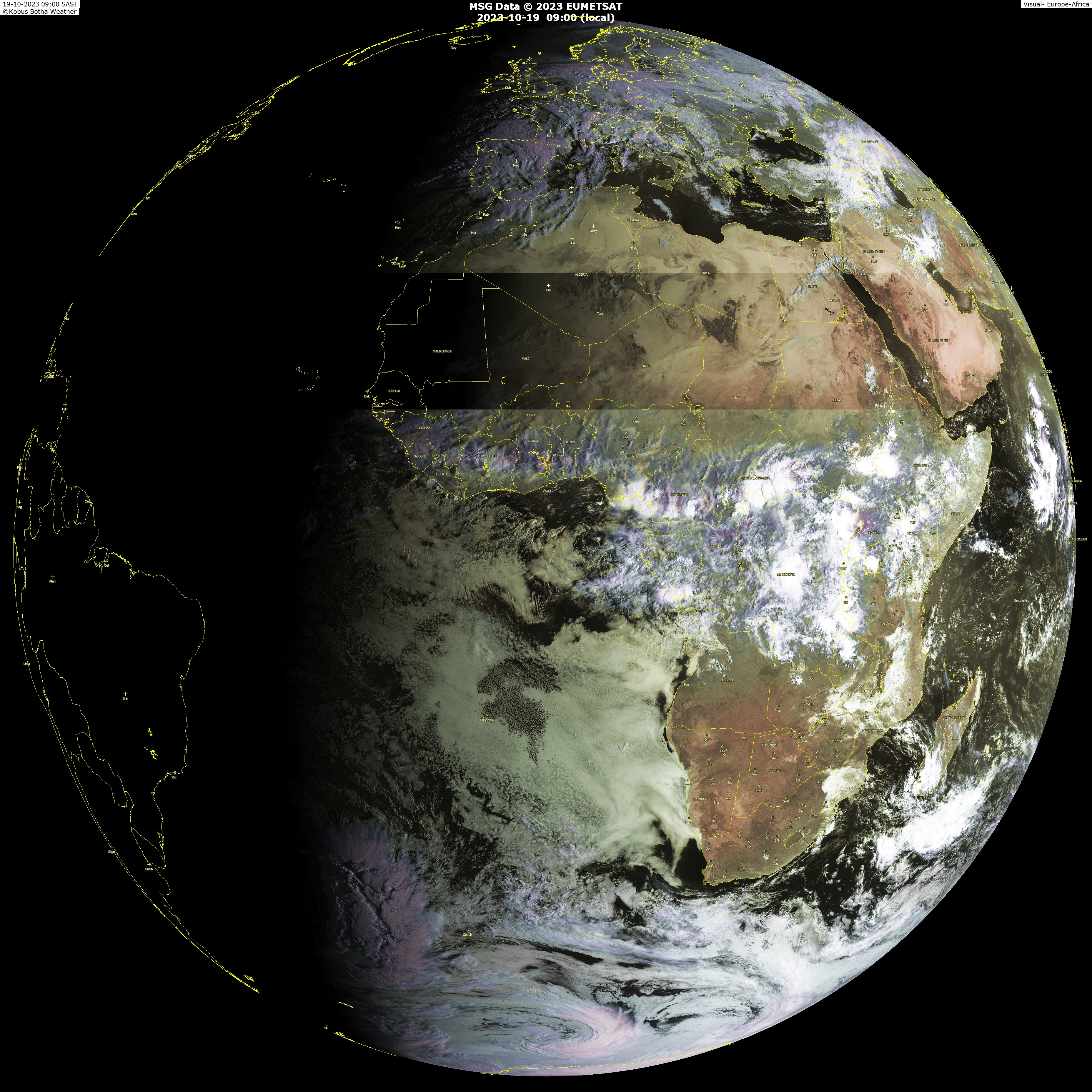
Here is a large image of the wave over Africa
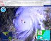
Sat Image

CMC at 126 hours

Image
0 likes   

User avatar
cycloneye
Admin
Admin
Posts: 145717
Age: 68
Joined: Thu Oct 10, 2002 10:54 am
Location: San Juan, Puerto Rico

Re: Wave Over Africa and Model Support

#2 Postby cycloneye » Thu Aug 07, 2008 7:07 am

GFS at 168 hours.Lets follow ther next runs of GFS,CMC,and lets see if NOGAPS,UKMET and the Euro join.

Image

288 Hours:

Image
0 likes   

User avatar
Hurricaneman13
Tropical Low
Tropical Low
Posts: 33
Joined: Tue Jul 22, 2008 10:33 pm

Re: Wave Over Africa and Model Support

#3 Postby Hurricaneman13 » Thu Aug 07, 2008 9:10 am

It would be interesting if this formed. It would probably be a classical Cape Verde storm IMO.
0 likes   

User avatar
kpost
Tropical Storm
Tropical Storm
Posts: 101
Age: 48
Joined: Sun Jul 06, 2008 10:52 am
Location: Indialantic, Florida (Ohio 4now)

Re: Wave Over Africa and Model Support

#4 Postby kpost » Thu Aug 07, 2008 9:34 am

if you play the GFS way into fantasy land (384 hrs), that wave could really suck for N. Carolina all the way to R.I.

http://www.arl.noaa.gov/ready/animations.html
0 likes   

User avatar
canegrl04
Category 5
Category 5
Posts: 2486
Joined: Thu Aug 26, 2004 5:37 pm
Location: Texas

Re: Wave Over Africa and Model Support

#5 Postby canegrl04 » Thu Aug 07, 2008 9:53 am

GFS has alittle more weight than the CMC.Should be interesting.I believe the GFS for intiating something,but it remains to be seen where it will go and how big it will get
0 likes   

User avatar
kpost
Tropical Storm
Tropical Storm
Posts: 101
Age: 48
Joined: Sun Jul 06, 2008 10:52 am
Location: Indialantic, Florida (Ohio 4now)

Re: Wave Over Africa and Model Support

#6 Postby kpost » Thu Aug 07, 2008 10:01 am

This is not a forecast of anything but pure fantasy land and should be taken as much.

All i know is this could make some nervous if the runs keep showing this. especially with the recent models stating too early of a recurve on the systems that have already happened. With the pattern so far this year on the models it could be anywhere on the east coast. How is GFS at predicting intensity?


Image
0 likes   

User avatar
Meso
Category 5
Category 5
Posts: 1609
Age: 38
Joined: Mon Aug 09, 2004 12:14 pm
Location: South Africa
Contact:

#7 Postby Meso » Thu Aug 07, 2008 11:51 am

Image

108 Hour GFS


Image

300 hour GFS
0 likes   

Scorpion

#8 Postby Scorpion » Thu Aug 07, 2008 11:52 am

Funny how about a year ago today the GFS started advertising a long tracker(Dean).
0 likes   

User avatar
cycloneye
Admin
Admin
Posts: 145717
Age: 68
Joined: Thu Oct 10, 2002 10:54 am
Location: San Juan, Puerto Rico

Re: Wave Over Africa and Model Support

#9 Postby cycloneye » Thu Aug 07, 2008 12:28 pm

The 12z Canadian continues to show the system moving westward.

Image

http://moe.met.fsu.edu/cgi-bin/cmctc2.c ... =Animation
0 likes   

User avatar
Blown Away
S2K Supporter
S2K Supporter
Posts: 10156
Joined: Wed May 26, 2004 6:17 am

Re:

#10 Postby Blown Away » Thu Aug 07, 2008 12:48 pm

Image
300 hour GFS


One thing for sure, the Bermuda High looks more impressive in the long range models. Any reliable model that has a developed system near the SE CONUS near August 24th gets my attention.
0 likes   

curtadams
S2K Supporter
S2K Supporter
Posts: 1122
Joined: Sun Aug 28, 2005 7:57 pm
Location: Orange, California
Contact:

#11 Postby curtadams » Thu Aug 07, 2008 1:17 pm

Looks to me like the possible cyclone forms from the next wave. It forms just off the coast of Africa in about 4 days.
0 likes   

User avatar
Cyclenall
Category 5
Category 5
Posts: 6667
Joined: Thu Jun 08, 2006 10:01 pm
Location: Ontario, Canada

#12 Postby Cyclenall » Thu Aug 07, 2008 2:15 pm

I started to notice this when looking at the runs for Kika. There is a growing amount of support for this.
0 likes   

User avatar
Ivanhater
Storm2k Moderator
Storm2k Moderator
Posts: 11162
Age: 38
Joined: Fri Jul 01, 2005 8:25 am
Location: Pensacola

Re: Wave Over Africa and Model Support

#13 Postby Ivanhater » Thu Aug 07, 2008 2:16 pm

This is interesting..and right on time for the cape verde season...
0 likes   

User avatar
cycloneye
Admin
Admin
Posts: 145717
Age: 68
Joined: Thu Oct 10, 2002 10:54 am
Location: San Juan, Puerto Rico

Re: Wave Over Africa and Model Support

#14 Postby cycloneye » Thu Aug 07, 2008 2:23 pm

UKMET joins the combo of models,although very weak showing.

Image
0 likes   

User avatar
TreasureIslandFLGal
S2K Supporter
S2K Supporter
Posts: 1581
Age: 57
Joined: Sun Aug 15, 2004 6:16 pm
Location: Clearwater, Florida ~3 miles from the coast now. We finally moved safely off the barrier island!

Re: Wave Over Africa and Model Support

#15 Postby TreasureIslandFLGal » Thu Aug 07, 2008 2:28 pm

Looks like the models are indicating a Bermuda High that is set pretty far to the east setting up. That would equal lots of recurves out to see or ones that impact Bermuda or simply scare the Outer Banks.

Actually, for CONUS, that is a set up that keeps most storms off our shores and harmlessly out to sea. (well, except for poor Bermuda)
0 likes   

User avatar
littlevince
S2K Supporter
S2K Supporter
Posts: 768
Joined: Fri Oct 21, 2005 10:45 am
Location: Portugal

Re: Wave Over Africa and Model Support

#16 Postby littlevince » Thu Aug 07, 2008 2:39 pm

GFS 12Z
Cyclone phase diagrams

Image
0 likes   

Derek Ortt

#17 Postby Derek Ortt » Thu Aug 07, 2008 3:03 pm

we know this is fantasy land

but I am hoping that the Bermuda high remains as pathetic as it has bene all season, as is depicted by the models.

in fact, let it weaken further so that the Carib and Bermuda can also be spared
0 likes   

User avatar
KWT
Category 5
Category 5
Posts: 31415
Joined: Tue Aug 17, 2004 11:02 am
Location: UK!!!

#18 Postby KWT » Thu Aug 07, 2008 3:09 pm

Indeed I agree Derek, the only thing I'm worried about is if we get any low trackers that get scooped up from the Caribbean...also I think there is probably at least a 50-50 chance that one storm is going to slip through the net towards the east coast, just hope its not as extreme as Hugo/Floyd if one does come through.
0 likes   

User avatar
Meso
Category 5
Category 5
Posts: 1609
Age: 38
Joined: Mon Aug 09, 2004 12:14 pm
Location: South Africa
Contact:

#19 Postby Meso » Thu Aug 07, 2008 4:58 pm

18z GFS : 72 hours

Image
0 likes   

User avatar
cycloneye
Admin
Admin
Posts: 145717
Age: 68
Joined: Thu Oct 10, 2002 10:54 am
Location: San Juan, Puerto Rico

Re: Wave Over Africa and Model Support

#20 Postby cycloneye » Thu Aug 07, 2008 5:07 pm

0 likes   


Return to “Talkin' Tropics”

Who is online

Users browsing this forum: cycloneye, duilaslol, JtSmarts and 20 guests