

Long week ahead.
Moderator: S2k Moderators


bvigal wrote:Hurakan, glad you posted that dvorak. I've been running the loop, and I think we'll have a depression in another hour.
http://www.ssd.noaa.gov/goes/flt/t1/loop-bd.html


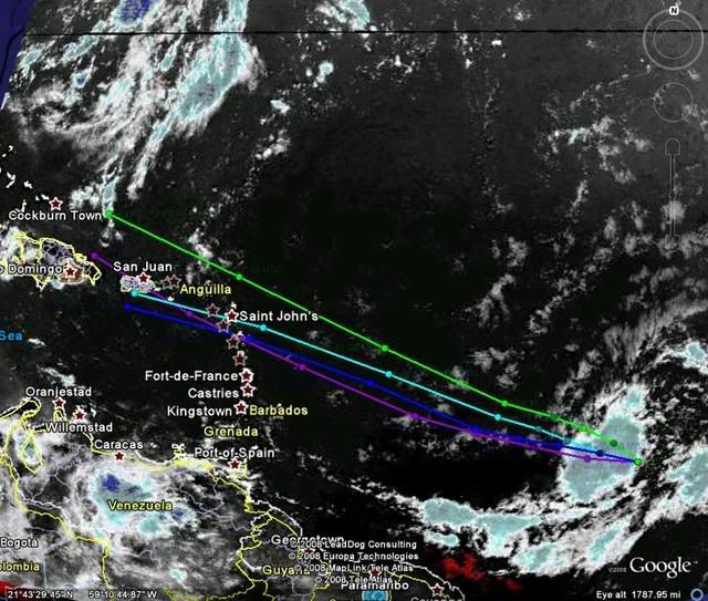
Recurve wrote:If you haven't seen it, check out the Google Earth link posted at NRL. Click the little KML button next to 92L on the home page. Very cool.
Ola wrote:
How you do that? Can you explain a bit more? Im at NRL but cant find a google earth link threre.


deltadog03 wrote:WXMAN, whats going on buddy?? Hey, thanks for that map from the GFS...Looks like EURO is also in fairly good agreement with the synoptic setup and the GFS. Question, if you have the time, is there anyway, we can find out what the steering levels looked like when Francis and Jeanne came into FL?? Can we find that out from the plymouth state site?
cycloneye wrote:Historiclly,when storms and hurricanes haved moved over or very close to Guadeloupe,Puerto Rico gets a landfall or a near miss,is like the Hebert box at 20n-60w for Florida,Guadeloupe is our box.
wxman57 wrote:deltadog03 wrote:WXMAN, whats going on buddy?? Hey, thanks for that map from the GFS...Looks like EURO is also in fairly good agreement with the synoptic setup and the GFS. Question, if you have the time, is there anyway, we can find out what the steering levels looked like when Francis and Jeanne came into FL?? Can we find that out from the plymouth state site?
I found this 500mb flow chart I made for Frances (I save a lot of stuff from each storm for my presentations):
http://myweb.cableone.net/nolasue/frances38.gif
Didn't have anything I'd saved for Jeanne.
Recurve wrote:Ola wrote:
How you do that? Can you explain a bit more? Im at NRL but cant find a google earth link threre.
There's a tiny little red button next to the label at the top of the NRL page. See this screen shot:

I'd be happy if NRL would re-position their sats from that old 41.3 fix. The west portion of 92L is already out of the closeup vis!Ola wrote:Cool thanks, but............. all I get is the 92l icon on google earth. Do you have more links for like sat overlays and stuff?Recurve wrote:There's a tiny little red button next to the label at the top of the NRL page. See this screen shot:Ola wrote:How you do that? Can you explain a bit more? Im at NRL but cant find a google earth link threre.
Ola wrote:Recurve wrote:Ola wrote:
How you do that? Can you explain a bit more? Im at NRL but cant find a google earth link threre.
There's a tiny little red button next to the label at the top of the NRL page. See this screen shot:
Cool thanks, but............. all I get is the 92l icon on google earth. Do you have more links for like sat overlays and stuff?
cycloneye wrote:HURAKAN wrote:
Follow the leader 92L.
The train has left the station.
Users browsing this forum: No registered users and 31 guests


