Weird cyclones - Impressive cyclones

This is the general tropical discussion area. Anyone can take their shot at predicting a storms path.

Moderator: S2k Moderators

Forum rules

The posts in this forum are NOT official forecasts and should not be used as such. They are just the opinion of the poster and may or may not be backed by sound meteorological data. They are NOT endorsed by any professional institution or STORM2K. For official information, please refer to products from the National Hurricane Center and National Weather Service.

Help Support Storm2K
Message
Author
User avatar
Category 5
Category 5
Category 5
Posts: 10074
Age: 35
Joined: Sun Feb 11, 2007 10:00 pm
Location: New Brunswick, NJ
Contact:

Re: Weird cyclones - Impressive cyclones

#161 Postby Category 5 » Sun Aug 10, 2008 10:11 pm

Squarethecircle wrote:
Honeyko wrote:
Squarethecircle wrote:...Katrina wasn't close to being annular).
These look a lot alike to me (Katrina vs. Isabel):

ImageImage
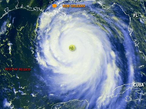
Katrina and Isabel have about the same CDO vs eye-size ratio (Katrina actually has the larger eye, relatively). I disagree with the notion that the presence of rainbands excludes a hurricane from consideration of being annular -- very few areas have an oceanic heat-content as extreme as the GOM loop-current. Note that Katrina easily meets all of the other annular characteristics.
wxmann_91 wrote:However, Katrina was nowhere near its maximum intensity possible, which was around 850 mb or something outrageous like that according to Dr. Emmanuel's MPI formula. I wouldn't really put Isabel and Katrina in the same category; while Isabel was steady "maxi-state", Katrina was hindered a bit by dry continental air in the vicinity, which inevitably led to the inner core near-collapse near landfall.
Katrina steady-stated at 160+mph with a giant eye for twelve or more hours prior to continental air intrusion:

19 25.20 -86.70 08/28/06Z 125 930 HURRICANE-4
20 25.70 -87.70 08/28/12Z 145 909 HURRICANE-5
21 26.30 -88.60 08/28/18Z 150 902 HURRICANE-5
22 27.20 -89.20 08/29/00Z 140 905 HURRICANE-5
23 28.20 -89.60 08/29/06Z 125 913 HURRICANE-4


But it had lots and lots of rainbands. :P

That's what an annular hurricane is - part of the definition. You can't decide to change that - it's not up to you.


Theres no reasoning with people who like to make up their own facts STC, stop wasting your time.
0 likes   

RL3AO
Moderator-Pro Met
Moderator-Pro Met
Posts: 16308
Joined: Thu Jun 14, 2007 10:03 pm
Location: NC

#162 Postby RL3AO » Sun Aug 10, 2008 10:25 pm

Katrina wasn't annular.
0 likes   

User avatar
cheezyWXguy
Category 5
Category 5
Posts: 6108
Joined: Mon Feb 13, 2006 12:29 am
Location: Dallas, TX

Re: Weird cyclones - Impressive cyclones

#163 Postby cheezyWXguy » Sun Aug 10, 2008 10:26 pm

Katrina was not annular. End of story. They dont look anything alike. The only thing is that they have similar eyes. I dont believe there has EVER been an annular hurricane in the gulf, nor do I think there ever will be as long as temps are warm. You do know that annularity has to do with the conditions around the storm, dont you? It consists of a fairly marginal environment with marginal sst's. That is what impacts the structure and makes it look the way it does.
0 likes   

User avatar
Cyclenall
Category 5
Category 5
Posts: 6667
Joined: Thu Jun 08, 2006 10:01 pm
Location: Ontario, Canada

Re:

#164 Postby Cyclenall » Sun Aug 10, 2008 11:36 pm

wxmann_91 wrote:-In the EPAC/CPAC, rest of WPAC, and open ATL, the morphology of major storms can vary, but small pinhole eyes are uncommon if any documented cases have occurred at all. Most times eyes are medium sized.

Small detail here, are you saying that pinhole eyes are extremely rare/nonexistent in the Epac? If that is what you meant, then I disagree because I have seen more then several over the last few years with one (Lane?, Sergio (2006)).
0 likes   

Ad Novoxium
Category 1
Category 1
Posts: 348
Age: 35
Joined: Sat May 03, 2008 2:12 am

Re: Re:

#165 Postby Ad Novoxium » Mon Aug 11, 2008 12:37 am

wxmann_91 wrote:-In the EPAC/CPAC, rest of WPAC, and open ATL, the morphology of major storms can vary, but small pinhole eyes are uncommon if any documented cases have occurred at all. Most times eyes are medium sized.

...
Image
That's a pinhole eye if I've ever seen one.
0 likes   

User avatar
Category 5
Category 5
Category 5
Posts: 10074
Age: 35
Joined: Sun Feb 11, 2007 10:00 pm
Location: New Brunswick, NJ
Contact:

Re: Weird cyclones - Impressive cyclones

#166 Postby Category 5 » Mon Aug 11, 2008 12:44 am

Image
Image
Image
0 likes   

Honeyko

Re: Weird cyclones - Impressive cyclones

#167 Postby Honeyko » Mon Aug 11, 2008 12:50 am

But it had lots and lots of rainbands. :P
That's what an annular hurricane is - part of the definition. You can't decide to change that - it's not up to you.
Theres no reasoning with people who like to make up their own facts
Image

Is it obliquely within the realm of possibility that you would accept that max-intensity Katrina shared all of the salient characteristics of an annular hurricane except for her retention of outer rainbands, a characteristic one could, I think, rationally assert is the least important among those listed on p206 of Knaff & Kossin's seminal study? Katrina's core "going truck-tire" southwest of Florida is immediately comparable to the evolution of Hurricane Howard, as depicted on p212. I'm far from the only person to contemplate it.

The Eskimos don't actually have twenty different words for types of snow, nor do we as many labels for types of hurricanes. When one meets most of the criteria for a particular type, it is reasonable to include it within that type (with provisos such "..., but with rainbands") for purposes of expediency, until such time as a new paper is written by authors who'll coin a new term for hurricanes which are very similar to annular hurricanes in all respects save retaining outer rainbands.
You do know that annularity has to do with the conditions around the storm, dont you? It consists of a fairly marginal environment with marginal sst's.
"...Composite analysis reveals that the typical annular hurricane exists in a very favorable hurricane environment...."
-- Knaff & Kossin, p221

Note that Isabel was advancing into warmer SSTs when she want annular. If EPAC annular hurricanes appear to go annular upon reaching cooler water, I'd assert it's merely a coincidence of them running out of warm water just as they've become completely evolved. Farther west, CPAC storms like Ioke and John (below) took very long tracks over warm SSTs and had CDOs with "truck tire" IR signatures, but otherwise had one large rainband.

Now, if the surrounding atmosphere were a bit more stable, enough to inhibit outer rainband activity at any rate, we'd be calling John annular, right? So, then, what term should we employ to describe an otherwise annular hurricane which is an environment conducive to also permitting peripheral convection?

Image
0 likes   

User avatar
Category 5
Category 5
Category 5
Posts: 10074
Age: 35
Joined: Sun Feb 11, 2007 10:00 pm
Location: New Brunswick, NJ
Contact:

Re: Weird cyclones - Impressive cyclones

#168 Postby Category 5 » Mon Aug 11, 2008 1:10 am

Honeyko wrote:
But it had lots and lots of rainbands. :P
That's what an annular hurricane is - part of the definition. You can't decide to change that - it's not up to you.
Theres no reasoning with people who like to make up their own facts
Image

Is it obliquely within the realm of possibility that you would accept that max-intensity Katrina shared all of the salient characteristics of an annular hurricane except for her retention of outer rainbands, a characteristic one could, I think, rationally assert is the least important among those listed on p206 of Knaff & Kossin's seminal study? Katrina's core "going truck-tire" southwest of Florida is immediately comparable to the evolution of Hurricane Howard, as depicted on p212. I'm far from the only person to contemplate it.

The Eskimos don't actually have twenty different words for types of snow, nor do we as many labels for types of hurricanes. When one meets most of the criteria for a particular type, it is reasonable to include it within that type (with provisos such "..., but with rainbands") for purposes of expediency, until such time as a new paper is written by authors who'll coin a new term for hurricanes which are very similar to annular hurricanes in all respects save retaining outer rainbands.
You do know that annularity has to do with the conditions around the storm, dont you? It consists of a fairly marginal environment with marginal sst's.
"...Composite analysis reveals that the typical annular hurricane exists in a very favorable hurricane environment...."
-- Knaff & Kossin, p221

Note that Isabel was advancing into warmer SSTs when she want annular. If EPAC annular hurricanes appear to go annular upon reaching cooler water, I'd assert it's merely a coincidence of them running out of warm water just as they've become completely evolved. Farther west, CPAC storms like Ioke and John (below) took very long tracks over warm SSTs and had CDOs with "truck tire" IR signatures, but otherwise had one large rainband.

Now, if the surrounding atmosphere were a bit more stable, enough to inhibit outer rainband activity at any rate, we'd be calling John annular, right? So, then, what term should we employ to describe an otherwise annular hurricane which is an environment conducive to also permitting peripheral convection?


Why do you continue to deny facts?

Heres the definition

An annular hurricane is a term used in the north Atlantic Ocean and northeastern Pacific Ocean east of the International Dateline. An anuular hurricane has a rare type of hurricane that has a big, circular eyewall, and thick, deep convection around it with no spiral rainbands.


Thats means ZERO. Katrina had more then ZERO.
0 likes   

Honeyko

#169 Postby Honeyko » Mon Aug 11, 2008 1:14 am

Were you going to answer the question?
0 likes   

User avatar
Category 5
Category 5
Category 5
Posts: 10074
Age: 35
Joined: Sun Feb 11, 2007 10:00 pm
Location: New Brunswick, NJ
Contact:

Re:

#170 Postby Category 5 » Mon Aug 11, 2008 1:19 am

Honeyko wrote:Were you going to answer the question?


I answered you with facts. Sorry if you got confused.

Trying to convince you is pointless, so I'll stop trying.
Last edited by Category 5 on Mon Aug 11, 2008 1:37 am, edited 1 time in total.
0 likes   

RL3AO
Moderator-Pro Met
Moderator-Pro Met
Posts: 16308
Joined: Thu Jun 14, 2007 10:03 pm
Location: NC

Re: Weird cyclones - Impressive cyclones

#171 Postby RL3AO » Mon Aug 11, 2008 1:28 am

Only rain bands you say?

1) the hurricane has a normal-to-large-sized
circular eye surrounded by a single band of deep convection
containing the inner-core region and 2) the hurricane
has little or no convective activity beyond this
annulus of convection.


Image

Image
0 likes   

Honeyko

#172 Postby Honeyko » Mon Aug 11, 2008 1:38 am

I asked:
"What term should we employ to describe an otherwise annular hurricane which is an environment conducive to also permitting peripheral convection?"
...and am receiving an apparent response of "Who cares?" I find it very disappointing that some do not believe that meaningful designations are useful in differentiating large-eyed hurricanes such as Katrina from small-eyed storms (even cat-5s) of lesser stature.
Last edited by Honeyko on Mon Aug 11, 2008 1:47 am, edited 1 time in total.
0 likes   

User avatar
Category 5
Category 5
Category 5
Posts: 10074
Age: 35
Joined: Sun Feb 11, 2007 10:00 pm
Location: New Brunswick, NJ
Contact:

Re:

#173 Postby Category 5 » Mon Aug 11, 2008 1:44 am

Honeyko wrote:I asked:
"What term should we employ to describe an otherwise annular hurricane which is an environment conducive to also permitting peripheral convection?"
...and am receiving an apparent response of "Who cares?" I find it very disappointing that some do not believe that meaningful designations are necessary to differentiate hurricanes such as Katrina from small-eye storms (even cat-5s) of lesser stature.


Meaningful designations, aka names.

We don't wanna put a bunch of meaningless labels on things, then people would get confused.
0 likes   

Honeyko

Re: Re:

#174 Postby Honeyko » Mon Aug 11, 2008 1:58 am

Category 5 wrote:We don't wanna put a bunch of meaningless labels on things, then people would get confused.
Terms like Knaff & Koffin created? :wink:

Image

==//==

Er, anyway..... Here's a weird and impressive cyclone: Dora, while at hurricane intensity, did not vary more than 4 degrees of latitude while traveling almost 70 degrees of longitude.

Image
0 likes   

arkestra
S2K Supporter
S2K Supporter
Posts: 88
Joined: Wed Jan 03, 2007 7:24 pm
Location: The Old Continent

Re:

#175 Postby arkestra » Mon Aug 11, 2008 7:09 am

wxmann_91 wrote:However, Katrina was nowhere near its maximum intensity possible, which was around 850 mb or something outrageous like that according to Dr. Emmanuel's MPI formula.

Is it physically possible, if conditions are good?
0 likes   

User avatar
Category 5
Category 5
Category 5
Posts: 10074
Age: 35
Joined: Sun Feb 11, 2007 10:00 pm
Location: New Brunswick, NJ
Contact:

Re: Re:

#176 Postby Category 5 » Mon Aug 11, 2008 7:32 am

Arkestra wrote:
wxmann_91 wrote:However, Katrina was nowhere near its maximum intensity possible, which was around 850 mb or something outrageous like that according to Dr. Emmanuel's MPI formula.

Is it physically possible, if conditions are good?


I doubt it is in the atlantic. MAYBE in the WPAC.
0 likes   

Honeyko

Re: Re:

#177 Postby Honeyko » Mon Aug 11, 2008 1:23 pm

Arkestra wrote:
wxmann_91 wrote:However, Katrina was nowhere near its maximum intensity possible, which was around 850 mb or something outrageous like that according to Dr. Emmanuel's MPI formula.
Is it physically possible, if conditions are good?
Doubtful; you'd be more likely to see that kind of pressure in a tiny pinhole eye storm (e.g., TC Monica) than a sprawling one with a big eye. (There's a body of thought that holds there's good reason to think Monica may have had a lower pressure than Tip.)
Last edited by Honeyko on Mon Aug 11, 2008 1:27 pm, edited 1 time in total.
0 likes   

User avatar
Category 5
Category 5
Category 5
Posts: 10074
Age: 35
Joined: Sun Feb 11, 2007 10:00 pm
Location: New Brunswick, NJ
Contact:

Re: Re:

#178 Postby Category 5 » Mon Aug 11, 2008 1:26 pm

Honeyko wrote:
Arkestra wrote:
wxmann_91 wrote:However, Katrina was nowhere near its maximum intensity possible, which was around 850 mb or something outrageous like that according to Dr. Emmanuel's MPI formula.
Is it physically possible, if conditions are good?
If the Gulf loop-current were a bigger feature and the hurricane were almost stationary....why not? But it isn't, and any moving 'cane will shift off the sweet spot quickly enough.


I don't think ambient pressures are low enough for an 850mb Hurricane in the Atlantic Basin. Can a pro met or someone with the answer shine some light on this?
0 likes   

Honeyko

Re: Re:

#179 Postby Honeyko » Mon Aug 11, 2008 1:29 pm

Augh! You quoted me as I was putting in my edit....I'll jump it forward:
Arkestra wrote:
wxmann_91 wrote:However, Katrina was nowhere near its maximum intensity possible, which was around 850 mb or something outrageous like that according to Dr. Emmanuel's MPI formula.
Is it physically possible, if conditions are good?
Doubtful; you'd be more likely to see that kind of pressure in a tiny pinhole eye storm (e.g., TC Monica or Hu Wilma) than a sprawling one with a big eye. (There's a body of thought that holds there's good reason to think Monica may have had a lower pressure than Tip.)
0 likes   

User avatar
Category 5
Category 5
Category 5
Posts: 10074
Age: 35
Joined: Sun Feb 11, 2007 10:00 pm
Location: New Brunswick, NJ
Contact:

Re: Re:

#180 Postby Category 5 » Mon Aug 11, 2008 1:36 pm

Honeyko wrote:Augh! You quoted me as I was putting in my edit....I'll jump it forward:
Arkestra wrote:
wxmann_91 wrote:However, Katrina was nowhere near its maximum intensity possible, which was around 850 mb or something outrageous like that according to Dr. Emmanuel's MPI formula.
Is it physically possible, if conditions are good?
Doubtful; you'd be more likely to see that kind of pressure in a tiny pinhole eye storm (e.g., TC Monica or Hu Wilma) than a sprawling one with a big eye. (There's a body of thought that holds there's good reason to think Monica may have had a lower pressure than Tip.)


Monica didn't have a pinhole eye at her peak.
0 likes   


Return to “Talkin' Tropics”

Who is online

Users browsing this forum: cycloneye, duilaslol, JtSmarts and 17 guests