Possible development SW of CV Islands (near 30W)
Moderator: S2k Moderators
Forum rules

The posts in this forum are NOT official forecasts and should not be used as such. They are just the opinion of the poster and may or may not be backed by sound meteorological data. They are NOT endorsed by any professional institution or STORM2K. For official information, please refer to products from the National Hurricane Center and National Weather Service.
-
carolina_73

- Tropical Storm

- Posts: 148
- Joined: Wed Jul 23, 2008 1:30 am
Re: Possible development off W Africa (near 30W)
This one being a low tracker could spell problems for alot of people if it really gets going. It will be hard to get a trough to recurve this one. Whatcha think?
0 likes
-
HURAKAN

- Professional-Met

- Posts: 46086
- Age: 38
- Joined: Thu May 20, 2004 4:34 pm
- Location: Key West, FL
- Contact:
Re: Possible development off W Africa (near 30W)
carolina_73 wrote:This one being a low tracker could spell problems for alot of people if it really gets going. It will be hard to get a trough to recurve this one. Whatcha think?
GFS is predicting a low-tracking system if I remember correctly.
0 likes
-
storms in NC

- S2K Supporter

- Posts: 2338
- Joined: Thu Jul 28, 2005 2:58 pm
- Location: Wallace,NC 40 miles NE of Wilm
- Contact:
Re: Possible development off W Africa (near 30W)
carolina_73 wrote:This one being a low tracker could spell problems for alot of people if it really gets going. It will be hard to get a trough to recurve this one. Whatcha think?
you don't need a tough to have a storm to recurve. Helps but don't have to have one.It has a lot to do with steering patterns and where the highs are and the lows are.
0 likes
-
cycloneye

- Admin

- Posts: 148740
- Age: 69
- Joined: Thu Oct 10, 2002 10:54 am
- Location: San Juan, Puerto Rico
Re: Possible development off W Africa (near 30W)
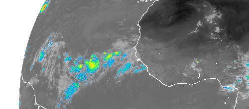
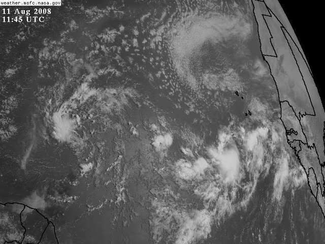
ABNT20 KNHC 111140
TWOAT
TROPICAL WEATHER OUTLOOK
NWS TPC/NATIONAL HURRICANE CENTER MIAMI FL
800 AM EDT MON AUG 11 2008
FOR THE NORTH ATLANTIC...CARIBBEAN SEA AND THE GULF OF MEXICO...
A BROAD AREA OF LOW PRESSURE ASSOCIATED WITH A TROPICAL WAVE IS
LOCATED OVER THE CENTRAL ATLANTIC OCEAN ABOUT 850 MILES EAST OF
THE WINDWARD ISLANDS. ALTHOUGH ASSOCIATED SHOWER AND THUNDERSTORM
ACTIVITY IS CURRENTLY LIMITED...ENVIRONMENTAL CONDITIONS APPEAR
FAVORABLE FOR GRADUAL DEVELOPMENT...AND THIS SYSTEM HAS THE
POTENTIAL TO BECOME A TROPICAL DEPRESSION DURING THE NEXT COUPLE OF
DAYS AS IT MOVES WESTWARD AT 15 TO 20 MPH.
 A LARGE AREA OF DISORGANIZED SHOWERS AND THUNDERSTORMS IS LOCATED
OVER THE EASTERN ATLANTIC A COUPLE HUNDRED MILES SOUTHWEST OF THE
CAPE VERDE ISLANDS. SLOW DEVELOPMENT OF THIS SYSTEM IS POSSIBLE
DURING THE NEXT COUPLE OF DAYS AS IT MOVES WESTWARD AT ABOUT 15
MPH.
ELSEWHERE.. TROPICAL CYCLONE FORMATION IS NOT EXPECTED DURING THE
NEXT 48 HOURS.
$$
FORECASTER RHOME
TWOAT
TROPICAL WEATHER OUTLOOK
NWS TPC/NATIONAL HURRICANE CENTER MIAMI FL
800 AM EDT MON AUG 11 2008
FOR THE NORTH ATLANTIC...CARIBBEAN SEA AND THE GULF OF MEXICO...
A BROAD AREA OF LOW PRESSURE ASSOCIATED WITH A TROPICAL WAVE IS
LOCATED OVER THE CENTRAL ATLANTIC OCEAN ABOUT 850 MILES EAST OF
THE WINDWARD ISLANDS. ALTHOUGH ASSOCIATED SHOWER AND THUNDERSTORM
ACTIVITY IS CURRENTLY LIMITED...ENVIRONMENTAL CONDITIONS APPEAR
FAVORABLE FOR GRADUAL DEVELOPMENT...AND THIS SYSTEM HAS THE
POTENTIAL TO BECOME A TROPICAL DEPRESSION DURING THE NEXT COUPLE OF
DAYS AS IT MOVES WESTWARD AT 15 TO 20 MPH.
OVER THE EASTERN ATLANTIC A COUPLE HUNDRED MILES SOUTHWEST OF THE
CAPE VERDE ISLANDS. SLOW DEVELOPMENT OF THIS SYSTEM IS POSSIBLE
DURING THE NEXT COUPLE OF DAYS AS IT MOVES WESTWARD AT ABOUT 15
MPH.
ELSEWHERE.. TROPICAL CYCLONE FORMATION IS NOT EXPECTED DURING THE
NEXT 48 HOURS.
$$
FORECASTER RHOME
0 likes

-
Derek Ortt

-
Stratosphere747
- Category 5

- Posts: 3772
- Joined: Thu Sep 11, 2003 8:34 pm
- Location: Surfside Beach/Freeport Tx
- Contact: