Ex Invest 93L in Central Atlantic
Moderator: S2k Moderators
Re: East Atlantic: Invest 93L
There's one problem with that. If 92L persists it will track over the islands where late formation isn't helped by land. This one has the look of a crasher. Dry and weakening LLC.
0 likes
-
storms in NC

- S2K Supporter

- Posts: 2338
- Joined: Thu Jul 28, 2005 2:58 pm
- Location: Wallace,NC 40 miles NE of Wilm
- Contact:
Re:
Derek Ortt wrote:models have backed off of this one forming as well
If I remember right the models down played Dean too. and look what he did? Not saying it it going to happen again but when the Lows are so far off I just don't put faith in Models till the get a little closer. But 92L is close to where they know what is going on with it. But 93 is a little far yet IMO. Models change from day to day.
0 likes
-
DESTRUCTION5

- Category 5

- Posts: 4430
- Age: 44
- Joined: Wed Sep 03, 2003 11:25 am
- Location: Stuart, FL
Re: East Atlantic: Invest 93L
Sanibel wrote:There's one problem with that. If 92L persists it will track over the islands where late formation isn't helped by land. This one has the look of a crasher. Dry and weakening LLC.
Then came Katrina...
0 likes

Re: East Atlantic: Invest 93L
93L is looking more and more impressive by the hour..Well on its wat to becoming a TD. The big question is where is it headed beyond 5 days?
0 likes


Re: East Atlantic: Invest 93L
Katrina was a fluke in an exceptional year where almost everything that spun formed. If you remember TD10 did a center burst out in the central Atlantic and I called it for sure formation. The convection then disappeared but the surface wave persisted. I had never seen a wave center burst like that and not form. TD10's wave then combined with another convected wave that needed a surface feature and formed Katrina. The GOM was a cloud of gasoline vapor needing a spark and this TD10 hybrid was the spark. So far I haven't seen any center burst with 92L.
(Topic is 93L): Looks like it is curling up.
(Topic is 93L): Looks like it is curling up.
0 likes
-
Gustywind

- Category 5
- Posts: 12334
- Joined: Mon Sep 03, 2007 7:29 am
- Location: Baie-Mahault, GUADELOUPE
Disturbances 92L, 93L a threat to the Lesser Antilles Islands
Posted by: JeffMasters, 10:33 AM EDT on August 11, 2008
http://www.wunderground.com/blog/JeffMa ... amp=200808
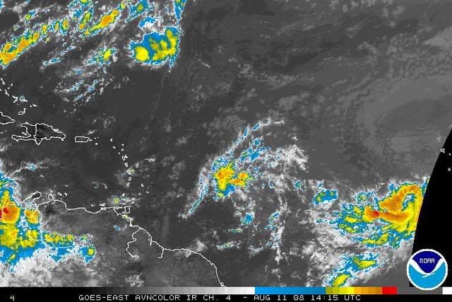
Disturbance 93L off the coast of Africa
A tropical wave near 11N 29W (93L), about 300 miles west-southwest of the Cape Verde Islands, has developed a modest amount of heavy thunderstorm activity overnight. A QuikSCAT pass at 5:55 am EDT this morning revealed no closed circulation, but did see top winds of 30 mph. Wind shear is a high 20 knots over the disturbance. Water vapor satellite imagery shows that 93L is embedded in a large area of moist air, with some dry air and Saharan dust to its north.
The forecast for 93L
Water temperatures are a warm 28° and forecast remain near 28°C for the next five days. Wind shear is forecast to drop below 10 knots by Tuesday night, and remain below 10 knots through Friday. Dry air may begin to be a problem for 93L beginning on Wednesday, as it works its way a bit further to the north where a dry Saharan Air Layer (SAL) exists. Odds are, 93L will be able to develop into a tropical depression by Friday. Most of the computer models are developing 93L into a tropical storm by early next week, and put it on a track to skirt the northernmost Lesser Antilles Islands. The National Hurricane Center is giving 93L a medium (20-50% chance) that it will be a tropical depression by Wednesday morning. Residents of and visitors to the Lesser Antilles should watch this system, as it has the potential to bring tropical storm conditions to the islands early next week.
A bit amazing all these invests...Troubles ahead after 92L for us in the Leewards ?!:eek: waouw it's already a textual nigthmare hope that it will be another phantom predictions (
  should it verfies as something first
  . We're far away from a direct threat with 93L for the moment, so let's enjoy the fair weather here with the sea and the coconuts:D
  ! Whereas as usual i'm monitoring the evolution case off.....
Posted by: JeffMasters, 10:33 AM EDT on August 11, 2008
http://www.wunderground.com/blog/JeffMa ... amp=200808
Disturbance 93L off the coast of Africa
A tropical wave near 11N 29W (93L), about 300 miles west-southwest of the Cape Verde Islands, has developed a modest amount of heavy thunderstorm activity overnight. A QuikSCAT pass at 5:55 am EDT this morning revealed no closed circulation, but did see top winds of 30 mph. Wind shear is a high 20 knots over the disturbance. Water vapor satellite imagery shows that 93L is embedded in a large area of moist air, with some dry air and Saharan dust to its north.
The forecast for 93L
Water temperatures are a warm 28° and forecast remain near 28°C for the next five days. Wind shear is forecast to drop below 10 knots by Tuesday night, and remain below 10 knots through Friday. Dry air may begin to be a problem for 93L beginning on Wednesday, as it works its way a bit further to the north where a dry Saharan Air Layer (SAL) exists. Odds are, 93L will be able to develop into a tropical depression by Friday. Most of the computer models are developing 93L into a tropical storm by early next week, and put it on a track to skirt the northernmost Lesser Antilles Islands. The National Hurricane Center is giving 93L a medium (20-50% chance) that it will be a tropical depression by Wednesday morning. Residents of and visitors to the Lesser Antilles should watch this system, as it has the potential to bring tropical storm conditions to the islands early next week.
A bit amazing all these invests...Troubles ahead after 92L for us in the Leewards ?!:eek:
0 likes
-
gatorcane

- S2K Supporter
- Posts: 23708
- Age: 48
- Joined: Sun Mar 13, 2005 3:54 pm
- Location: Boca Raton, FL
Re: East Atlantic: Invest 93L
Vortex wrote:93L is looking more and more impressive by the hour..Well on its wat to becoming a TD. The big question is where is it headed beyond 5 days?
Generally West. I see no recurve possibility within 5 days. Look at the heights across the Northern subtropical atlantic even out to day 5. The deep red near Bermuda suggests a building Bermuda High feature.

By day 10 though the Bermuda High appears to break down some, allowing for a possible recurve:

Last edited by gatorcane on Mon Aug 11, 2008 9:59 am, edited 1 time in total.
0 likes

>>The GOM was a cloud of gasoline vapor needing a spark and this TD10 hybrid was the spark. So far I haven't seen any center burst with 92L.
Yeah, I think TD10 eventually became TD12 or something after it busted a trough. That was a tenacious bundle of energy. The entire basin was a cauldron in 2005, but it seems as though 2008 also features systems that want to get going. I could be wrong, but didn't Edouard represent the 2nd or 3rd fastest "E" storm, so something has been right thus far. I realize the entire basin isn't the gas pit it was in 2005, but still...
http://www.osdpd.noaa.gov/PSB/EPS/SST/climo.html
Steve
0 likes
-
Gustywind
- Category 5
- Posts: 12334
- Joined: Mon Sep 03, 2007 7:29 am
- Location: Baie-Mahault, GUADELOUPE
Re: East Atlantic: Invest 93L
gatorcane wrote:Vortex wrote:93L is looking more and more impressive by the hour..Well on its wat to becoming a TD. The big question is where is it headed beyond 5 days?
Generally West. I see no recurve possibility within 5 days. Look at the heights across the Northern subtropical atlantic even out to day 5. The deep red near Bermuda suggests a building Bermuda High feature.
By day 10 though the Bermuda High appears to break down some, allowing for a possible recurve:
So Gatorcane do you tkink it has chances to be near the Leewards islands?
0 likes
-
gatorcane
- S2K Supporter
- Posts: 23708
- Age: 48
- Joined: Sun Mar 13, 2005 3:54 pm
- Location: Boca Raton, FL
WV imagery suggests there is plenty of moist air for 93L to work with...I think 93L ends up developing first (not 92L).

Last edited by gatorcane on Mon Aug 11, 2008 10:04 am, edited 2 times in total.
0 likes
-
frederic79

- Category 1

- Posts: 271
- Joined: Sun Jul 18, 2004 8:48 pm
- Location: Grand Bay, AL
Re: East Atlantic: Invest 93L
Anybody remember the history of that terrible tandem of David and Frederic? That's what this reminds me of, should 92L and 93L both develop.
0 likes
-
MGC

- S2K Supporter
- Posts: 5940
- Joined: Sun Mar 23, 2003 9:05 pm
- Location: Pass Christian MS, or what is left.
Re: East Atlantic: Invest 93L
93L appears to be becoming better organized. Of course this season we've witnessed several such disturbances with excellent apparent organization only to poof. 93 appears to have a chance to spin though.....MGC
0 likes

Re: East Atlantic: Invest 93L
The 00Z Euro shows a solid 500 mb ridge extending into the central gulf coast over the next 7-10 days. While the GFS wants to recurve 93L, the ECMWF does not. Have to wait and see on the long term track of this one.
http://www.ecmwf.int/products/forecasts/d/charts/medium/deterministic/msl_uv850_z500!Geopotential%20500%20hPa!192!North%20America!pop!od!oper!public_plots!2008081100!!/
http://www.ecmwf.int/products/forecasts/d/charts/medium/deterministic/msl_uv850_z500!Geopotential%20500%20hPa!192!North%20America!pop!od!oper!public_plots!2008081100!!/
0 likes
-
Stormcenter
- S2K Supporter
- Posts: 6689
- Joined: Wed Sep 03, 2003 11:27 am
- Location: Houston, TX
Re: East Atlantic: Invest 93L
So far there is pretty much nothing to get excited about with 92L and 93L.
The models seem to feel the same way too.
The models seem to feel the same way too.
0 likes
-
Gustywind
- Category 5
- Posts: 12334
- Joined: Mon Sep 03, 2007 7:29 am
- Location: Baie-Mahault, GUADELOUPE
Good point and nice post frederic79, hey, the nigtmare for the East Carib islands at this period don't tell it too strong lol...not good moments for us in the islands  David had crossed vigorously Martinica the 29 th of August as strong cane in 1979 and putting strong winds in the south tip of the island near HUC location at Basse Terre with numerous and severe damages in each island ( Martinica and Guadeloupe ) and Frederic has hit Guadeloupe as a cane the 3rd of September 1979. Hope nothing to bad from these two invests... .
0 likes
Who is online
Users browsing this forum: No registered users and 34 guests