ATL: Tropical Depression Fay
Moderator: S2k Moderators

-
cycloneye

- Admin

- Posts: 149291
- Age: 69
- Joined: Thu Oct 10, 2002 10:54 am
- Location: San Juan, Puerto Rico
Re: ATL: Invest 92L - Central Atlantic
Even odds this doesn't miss Puerto Rico.
Any science to this? I ask as many members are in Puerto Rico including me.
0 likes

Certainly would be a dangerous system though I bet the inner core would be wrecked if it took that track...
Pretty close to model guidence as well, a mix between the Euro and the GFS based models. I've got a sneaky feeling given this WNw/NW track wasn't really forecasted it'll end up just a little to the north of that, GFDL track looks close IMO...BUT if it takes the other track option it would end up in the gulf and possibly take a Georges track.
Pretty close to model guidence as well, a mix between the Euro and the GFS based models. I've got a sneaky feeling given this WNw/NW track wasn't really forecasted it'll end up just a little to the north of that, GFDL track looks close IMO...BUT if it takes the other track option it would end up in the gulf and possibly take a Georges track.
0 likes
-
tolakram
- Admin
- Posts: 20179
- Age: 62
- Joined: Sun Aug 27, 2006 8:23 pm
- Location: Florence, KY (name is Mark)
Re: ATL: Invest 92L - Central Atlantic
I have to ask... When (or how often) has an invest like this put on deep convection during dmin and not made it to a TD soon after. Just asking, not predicting.
0 likes
-
Brent
- S2K Supporter

- Posts: 38729
- Age: 37
- Joined: Sun May 16, 2004 10:30 pm
- Location: Tulsa Oklahoma
- Contact:
Re: ATL: Invest 92L - Central Atlantic
WOW, this looks really good suddenly and at the DMIN too. Be interesting to see if it persists.
0 likes
-
Stratosphere747
- Category 5

- Posts: 3772
- Joined: Thu Sep 11, 2003 8:34 pm
- Location: Surfside Beach/Freeport Tx
- Contact:
-
canetracker

- S2K Supporter
- Posts: 751
- Age: 63
- Joined: Wed Jul 27, 2005 8:49 pm
- Location: Suburbia New Orleans...Harahan, LA
Re:
KWT wrote:Certainly would be a dangerous system though I bet the inner core would be wrecked if it took that track...
Pretty close to model guidence as well, a mix between the Euro and the GFS based models. I've got a sneaky feeling given this WNw/NW track wasn't really forecasted it'll end up just a little to the north of that, GFDL track looks close IMO...BUT if it takes the other track option it would end up in the gulf and possibly take a Georges track.
I thought the track was forecasted to go wnw/nw at least thats what I have been seeing in the model data:
http://my.sfwmd.gov/sfwmd/common/images/weather/plots/storm_92.gif
0 likes

Re: ATL: Invest 92L - Central Atlantic
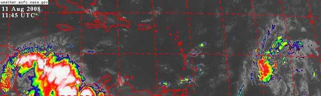
The trough doesn't seem to want to lift out in a hurry, which could affect 92L's outcome on track.Well see what the models say tonight.
http://www.ssd.noaa.gov/goes/east/tatl/avn-l.jpg
http://www.ssd.noaa.gov/goes/east/tatl/avn-l.jpg
0 likes
-
Stormcenter
- S2K Supporter
- Posts: 6689
- Joined: Wed Sep 03, 2003 11:27 am
- Location: Houston, TX
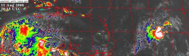
My "early" vote is for a recurve. It is way too north already. Yeah I know the "Bermuda ridge" is suppose to build back but I don't buy it right now. We shall see.
http://www.ssd.noaa.gov/goes/east/catl/avn-l.jpg
http://www.ssd.noaa.gov/goes/east/catl/avn-l.jpg
0 likes
-
gatorcane

- S2K Supporter
- Posts: 23708
- Age: 48
- Joined: Sun Mar 13, 2005 3:54 pm
- Location: Boca Raton, FL
Its still gaining some good lattitude though, and about to cross the 15N threshold I mentioned above:
http://metofis.rsmas.miami.edu/~dortt/s ... 1_loop.gif
http://metofis.rsmas.miami.edu/~dortt/s ... 1_loop.gif
0 likes
-
HURAKAN

- Professional-Met

- Posts: 46084
- Age: 39
- Joined: Thu May 20, 2004 4:34 pm
- Location: Key West, FL
- Contact:
Re:
KWT wrote:Got to admit the deep convection is really impressing me but needs to hold for a lot longer to really help develop that circulation but at this stage odds for development must be increasing again.
I heard the bets between the basketball referees are increasing again in favor of 92L!!! Sorry if you're a basketball fan and this didn't sound nice!!!
0 likes
-
tolakram
- Admin
- Posts: 20179
- Age: 62
- Joined: Sun Aug 27, 2006 8:23 pm
- Location: Florence, KY (name is Mark)
Re:
KWT wrote:Got to admit the deep convection is really impressing me but needs to hold for a lot longer to really help develop that circulation but at this stage odds for development must be increasing again.
Doesn't that assume that the circulation shown in yesterdays QS pass was disrupted? I'm not sure it was.
Last edited by tolakram on Mon Aug 11, 2008 4:02 pm, edited 1 time in total.
0 likes
-
Scorpion
The models yesterday had a track probably around 285 and its further north then was progged at this stage as well, esp given the real center is probably up at 14N.
Track seems bang on GFDL...
Track seems bang on GFDL...
Last edited by KWT on Mon Aug 11, 2008 4:03 pm, edited 1 time in total.
0 likes
-
MiamiensisWx
Re:
Stormcenter wrote:My "early" vote is for a recurve. It is way too north already. Yeah I know the "Bermuda ridge" is suppose to build back but I don't buy it right now. We shall see.
http://www.ssd.noaa.gov/goes/east/catl/avn-l.jpg
The LLC is south of 15 N. That is not "too far north" for a CONUS threat, based on analysis of past history. Additionally, it still poses a threat to the southern Leeward Islands.
Last edited by MiamiensisWx on Mon Aug 11, 2008 4:04 pm, edited 2 times in total.
0 likes
Re: ATL: Invest 92L - Central Atlantic
I think the system was stationary for several hours and consolidating before heading west or w/nw.
0 likes
-
gatorcane
- S2K Supporter
- Posts: 23708
- Age: 48
- Joined: Sun Mar 13, 2005 3:54 pm
- Location: Boca Raton, FL
Re: Re:
MiamiensisWx wrote:Stormcenter wrote:My "early" vote is for a recurve. It is way too north already. Yeah I know the "Bermuda ridge" is suppose to build back but I don't buy it right now. We shall see.
http://www.ssd.noaa.gov/goes/east/catl/avn-l.jpg
The LLC is south of 15 N. That is not "too far north", and it still poses a threat to the southern Leeward Islands.
Indeed as long as it keeps gaining lattitude its more of a NE Leeward islands-Bahamas-FL threat (if that Bermuda High does catch it) Its also looking increasingly likely 92L will pass through Herbert box #1:
http://www.hurricanecity.com/hebertbox.htm
Last edited by gatorcane on Mon Aug 11, 2008 4:06 pm, edited 2 times in total.
0 likes
Who is online
Users browsing this forum: No registered users and 12 guests