ATL: Tropical Depression Fay
Moderator: S2k Moderators


Re: ATL: Invest 92L - Central Atlantic=8 PM TWO,Red
Interesting how the Euro really pumps up the mid-level ridge and squashes 92L down to a W or W-SW course after reaching the north coast of Hispanola. This brings the system south of Cuba back into the NW caribbean and then eventually into the central GOM. This ridge may actually protect FL and deflect the storm south of the state. Either that or the ridge is weaker allowing 92L to move W-NW across the straits or S FL. We'll probably know better ina few days. I think the possibility of a recurve east of FL is remote.
0 likes
Re: ATL: Invest 92L - Central Atlantic=8 PM TWO,Red
I posted yesterday that the Bermuda High extension was pushed south of Florida by the front. What worries me about this is a red IR storm that will possibly trend right as the continental flow pushes the trough east. Red IR in this position doesn't usually fade.
0 likes

Re: ATL: Invest 92L - Central Atlantic=8 PM TWO,Red
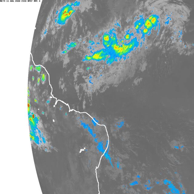
TROPICAL WEATHER DISCUSSION
NWS TPC/NATIONAL HURRICANE CENTER MIAMI FL
805 PM EDT MON AUG 11 2008
TROPICAL WEATHER DISCUSSION FOR NORTH AMERICA...CENTRAL
AMERICA...GULF OF MEXICO...CARIBBEAN SEA...NORTHERN SECTIONS
OF SOUTH AMERICA...AND ATLANTIC OCEAN TO THE AFRICAN COAST
FROM THE EQUATOR TO 32N. THE FOLLOWING INFORMATION IS BASED
ON SATELLITE IMAGERY...METEOROLOGICAL ANALYSIS...WEATHER
OBSERVATIONS...AND RADAR.
BASED ON 1800 UTC SURFACE ANALYSIS AND SATELLITE IMAGERY THROUGH
2315 UTC.
...SPECIAL FEATURES...
A TROPICAL WAVE LOCATED E OF THE WINDWARD ISLANDS ALONG 49W
MOVING W AT 15 KT. A 1008 MB LOW IS EMBEDDED ON THE WAVE AXIS
NEAR 12N49W. SCATTERED MODERATE TO STRONG CONVECTION IS N OF THE
LOW CENTER FROM 13N-17N BETWEEN 47W-51W. ENVIRONMENTAL
CONDITIONS APPEAR FAVORABLE FOR GRADUAL DEVELOPMENT...AND THIS
SYSTEM HAS THE POTENTIAL TO BECOME A TROPICAL DEPRESSION DURING
THE NEXT COUPLE OF DAYS.
What's 13N to 17N -- 240 nmiles?
0 likes
-
Extremeweatherguy

- Category 5

- Posts: 11095
- Joined: Mon Oct 10, 2005 8:13 pm
- Location: Florida
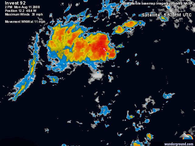
Here is an update from Jeff Masters that he put out a few hours ago...
A Ph.D. meteorologist saying that 92L is "destined to become a tropical depression by Tuesday night or Wednesday", definitely gets my attention.
Update on disturbance 92L approaching Lesser Antilles
A tropical wave about 800 miles east of the Lesser Antilles Islands (92L) has had its center reform today farther to the north. This location is difficult to pinpoint (I put it at 13.5N 48W at 4 pm EDT), but is farther away from the dry air to its west. The center was forced to re-form after dry air disrupted the original circulation early this morning. Thanks to the center re-location, dry air is troubling 92L much less, and visible satellite loops show a steady increase in heavy thunderstorm activity and organization, and surface spiral bands have formed to the west and north. Water vapor satellite loops show that a large area of dry air and Saharan dust lies to the west of 92L's center, and this dry air does not appear to be getting drawn into the storm's center any more.
The forecast for 92L
Water temperatures are a warm 28.2°C and forecast to increase to 28.8°C five days from now. Wind shear is forecast to remain below 10 knots for the next four days, then increase to 10-15 knots five days from now. This environment is favorable for intensification. The models are split on whether 92L will develop or not. The 2 am EDT GFDL model is the most aggressive, intensifying 92L to a 55 mph tropical storm that passes just north of the northernmost Lesser Antilles Islands on Thursday. In contrast, the 2 am EDT HWRF model does not develop 92L at all. The National Hurricane Center is giving 92L a medium (20-50% chance) of becoming a tropical depression by Wednesday afternoon. This is a step down from their forecast last night of a high (>50%) chance of developing, and reflects the uncertainty that 92L will be able to get organized in the face of significant dry air to its west. However, given the recent trend in visible, infrared, and water vapor satellite imagery, I believe 92L has sufficiently insulated itself from the dry air to the west, and is destined to become a tropical depression by Tuesday night or Wednesday. Residents of and visitors to the northern Lesser Antilles should anticipate the possibility of a tropical depression or tropical storm arriving in the islands as early as Wednesday afternoon (though Thursday morning is more likely). The southern islands are not likely to be affected. Puerto Rico could be affected by Thursday, the Dominican Republic by Friday, and the Bahamas by Saturday. The U.S. East Coast could be affected by this system early next week, although it is too early to assess whether the system may end up recurving out to sea or not. The Hurricane Hunters are scheduled to pay their first visit to 92L on Tuesday afternoon.
A Ph.D. meteorologist saying that 92L is "destined to become a tropical depression by Tuesday night or Wednesday", definitely gets my attention.
Last edited by Extremeweatherguy on Mon Aug 11, 2008 7:21 pm, edited 1 time in total.
0 likes


Re: ATL: Invest 92L - Central Atlantic
Here we go.

(edit: and I pledge only meaningful posts on this sytem from now on).
(edit: and I pledge only meaningful posts on this sytem from now on).
0 likes
-
cycloneye

- Admin

- Posts: 148750
- Age: 69
- Joined: Thu Oct 10, 2002 10:54 am
- Location: San Juan, Puerto Rico
Re: ATL: Invest 92L - Central Atlantic
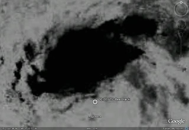
00:00 UTC Best track:
AL, 92, 2008081200, , BEST, 0, 135N, 482W, 25, 1008, DB, 0, , 0, 0, 0, 0,
ftp://ftp.tpc.ncep.noaa.gov/atcf/tcweb/
AL, 92, 2008081200, , BEST, 0, 135N, 482W, 25, 1008, DB, 0, , 0, 0, 0, 0,
ftp://ftp.tpc.ncep.noaa.gov/atcf/tcweb/
0 likes


-
wzrgirl1

- S2K Supporter

- Posts: 1360
- Joined: Sat Sep 04, 2004 6:44 am
- Location: Pembroke Pines, Florida
Re: ATL: Invest 92L - Central Atlantic
sure has improved with convection since yesterday evening....probably a td sometime tomorrow at this rate
0 likes
-
curtadams
- S2K Supporter
- Posts: 1122
- Joined: Sun Aug 28, 2005 7:57 pm
- Location: Orange, California
- Contact:
Re: ATL: Invest 92L - Central Atlantic
Large area of W moving low clouds now - almost certainly closed.
0 likes
Re: ATL: Invest 92L - Central Atlantic
AJC3 wrote:Late afternoon WINDSAT scatterometer pass...

here is the wind sat showing where the llc was located earlier. Thanks for posting AJC3!
0 likes

Re: ATL: Invest 92L - Central Atlantic
The buoy just to the west of the center hasn't reported in 5 hours. Its last report was at 4pm ET and had NE winds at 12kt and a pressure of 1008.1 mb and falling.
http://www.ndbc.noaa.gov/station_page.php?station=41nt0
http://www.ndbc.noaa.gov/station_page.php?station=41nt0
0 likes
Who is online
Users browsing this forum: No registered users and 15 guests