ATL: Tropical Depression Fay
Moderator: S2k Moderators
-
jasons2k

- Storm2k Executive

- Posts: 8290
- Age: 52
- Joined: Wed Jul 06, 2005 12:32 pm
- Location: The Woodlands, TX
Re: ATL: Invest 92L - Central Atlantic
I'm watching this one closely, I think it will develop and has a good chance of impacting a lot of land areas.
0 likes


-
Derek Ortt
-
MiamiensisWx
Re: ATL: Invest 92L - Central Atlantic
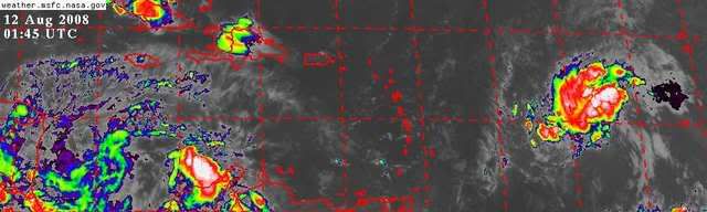
LLC is situated under the convection on the southeast side:
http://www.nrlmry.navy.mil/tcdat/tc08/ATL/92L.INVEST/ssmi/composite/20080811.2059.f13.x.composite.92LINVEST.25kts-1008mb-122N-484W.39pc.jpg
Movement appears to be N of due W per satellite data.
http://www.nrlmry.navy.mil/tcdat/tc08/ATL/92L.INVEST/ssmi/composite/20080811.2059.f13.x.composite.92LINVEST.25kts-1008mb-122N-484W.39pc.jpg
Movement appears to be N of due W per satellite data.
Last edited by MiamiensisWx on Mon Aug 11, 2008 9:42 pm, edited 1 time in total.
0 likes
-
tolakram
- Admin
- Posts: 20179
- Age: 62
- Joined: Sun Aug 27, 2006 8:23 pm
- Location: Florence, KY (name is Mark)
Re: ATL: Invest 92L - Central Atlantic
Convection appears to be on the wane again.

Where is the latest center estimate. I can't see anything in that mess.

Is that it around 50, 15?
Where is the latest center estimate. I can't see anything in that mess.
Is that it around 50, 15?
0 likes

Re: ATL: Invest 92L - Central Atlantic
00Z NAM
Indicates a well developed storm at the end of the run with very favorable upper air support.
http://www.nco.ncep.noaa.gov/pmb/nwprod ... p_084l.gif
Indicates a well developed storm at the end of the run with very favorable upper air support.
http://www.nco.ncep.noaa.gov/pmb/nwprod ... p_084l.gif
0 likes
-
Derek Ortt

-
Blown Away

- S2K Supporter

- Posts: 10253
- Joined: Wed May 26, 2004 6:17 am
Re: ATL: Invest 92L - Central Atlantic
Is the convection starting to build on more than on side of the circulation? Looks like it to me. The TAFB has 92L just N of PR in 72 hours and misses the NE Caribbean. It seems 92L has picked up a little speed and is moving more WNW again.
http://www.nhc.noaa.gov/tafb_latest/atl ... BW_sm3.gif
0 likes
-
ConvergenceZone
.gif)
- Category 5

- Posts: 5241
- Joined: Fri Jul 29, 2005 1:40 am
- Location: Northern California
-
Blown Away
- S2K Supporter
- Posts: 10253
- Joined: Wed May 26, 2004 6:17 am
Re: ATL: Invest 92L - Central Atlantic

92L is looking so good tonight compared to last night. Convection is starting to build around the circulation, if this continues and convection starts to build on the S side of the circulation we may have a TD in the morning, IMO. If the 92L becomes a TD in the morning the 5 day error cone will likely be very close to SFL. It's coming I can feel it!!
0 likes
-
Extremeweatherguy

- Category 5
- Posts: 11095
- Joined: Mon Oct 10, 2005 8:13 pm
- Location: Florida
Re: ATL: Invest 92L - Central Atlantic
Must be trying to copy its older sister Dolly (a.k.a. 94L).Scorpion wrote:What a frustrating system to track. Seems to take 1 step forward 1 step back.
Last edited by Extremeweatherguy on Mon Aug 11, 2008 10:58 pm, edited 1 time in total.
0 likes
-
Blown Away
- S2K Supporter
- Posts: 10253
- Joined: Wed May 26, 2004 6:17 am
Re: ATL: Invest 92L - Central Atlantic
Looking at the WV loop I think we will see more of a WNW track before to long.
0 likes
-
SouthFLTropics

- Category 5
- Posts: 4258
- Age: 50
- Joined: Thu Aug 14, 2003 8:04 am
- Location: Port St. Lucie, Florida
Re: ATL: Invest 92L - Central Atlantic
Seems like they have all been like this so far...These invests can be frustrating...it's like a rollercoaster ride! One minute its building convection and then the next it 
0 likes
-
Derek Ortt
Re:
ConvergenceZone wrote:I noticed that most of the METS on here seem bearish on ANY development at all of this...I'm just curious what the METS who put together the TWOs are seeing that our METS here aren't? or vice versa?.... The last TWO for example seems very bullish with this wave.....
I'm not too sure why there is the descrepency.
Maybe watch it in the Bahamas, but I dont see anything before then
0 likes
-
hurricanetrack

- HurricaneTrack.com
- Posts: 1781
- Joined: Tue Dec 02, 2003 10:46 pm
- Location: Wilmington, NC
- Contact:
We are perhaps just a little shy of the time when such systems truly blossom. Even a few days short of the traditional ramp up to where climatology would strongly suggest development is enough to retard it this far east for now. Bertha and that TD for 6 hours between Dakar and the Cape Verde Islands had excellent conditions. It's all coming together. Remember, we can watch these darn things till the cows come home now- literally. Like waiting for water to boil. Almost literally. Hang in there people, for those who truly like to track the big hurricanes, I feel your time is coming. So do a few other people who hold degrees in meteorology and other related fields- some even have a PhD before their names. We are still in early August...time will change things. Just my thoughts as I look at everything tonight.
0 likes
-
Stormcenter
- S2K Supporter
- Posts: 6689
- Joined: Wed Sep 03, 2003 11:27 am
- Location: Houston, TX
Re:
Scorpion wrote:True, its only August 12. Things really usually pick up late in the month.
The meat and potatoes (the really big ones) of the season is between August 15th through September 15th.
I personally will be glad when we are in late October and hopefully nothing of any significance has developed.
0 likes
-
tolakram
- Admin
- Posts: 20179
- Age: 62
- Joined: Sun Aug 27, 2006 8:23 pm
- Location: Florence, KY (name is Mark)
Re: ATL: Invest 92L - Central Atlantic
Good loop where you can see the mainly west motion and convection following the center.
http://hadar.cira.colostate.edu/ramsdis ... at1_0.html
http://hadar.cira.colostate.edu/ramsdis ... at1_0.html
0 likes
Who is online
Users browsing this forum: No registered users and 55 guests