ATL: Tropical Depression Fay

Moderator: S2k Moderators

Message
Author
User avatar
gatorcane
S2K Supporter
S2K Supporter
Posts: 23691
Age: 47
Joined: Sun Mar 13, 2005 3:54 pm
Location: Boca Raton, FL

Re:

#1161 Postby gatorcane » Tue Aug 12, 2008 3:26 pm

Derek Ortt wrote:recon very unimpressive

nothing to see folks


not surprising, probably won't starting really organizing until it gets under the East to West Upper-Level winds in about 36 hours. Nothing to see now but I really do think we are nearing liftoff in 24-36 hours once it bypasses the TUTT to the north.
Last edited by gatorcane on Tue Aug 12, 2008 3:27 pm, edited 1 time in total.
0 likes   

txwatcher91
Category 5
Category 5
Posts: 1498
Joined: Tue Aug 02, 2005 2:29 pm

Re:

#1162 Postby txwatcher91 » Tue Aug 12, 2008 3:26 pm

Aquawind wrote:Woah..937mb?


Nope, 987.
0 likes   

User avatar
Aquawind
Category 5
Category 5
Posts: 6714
Age: 62
Joined: Mon Jun 16, 2003 10:41 pm
Location: Salisbury, NC
Contact:

Re: Re:

#1163 Postby Aquawind » Tue Aug 12, 2008 3:27 pm

MiamiensisWx wrote:
Aquawind wrote:Woah..937mb?

It's actually ~987 mb...


that's more like it..well kinda
0 likes   

User avatar
storms in NC
S2K Supporter
S2K Supporter
Posts: 2338
Joined: Thu Jul 28, 2005 2:58 pm
Location: Wallace,NC 40 miles NE of Wilm
Contact:

Re: ATL: Invest 92L - Central Atlantic - TCFA issued

#1164 Postby storms in NC » Tue Aug 12, 2008 3:27 pm

MY MY What things I read. It is dieing it is breaking down. I am writing it off. We know where it is going. You should really go back and read. It is a wast of space.
Now I need to go and put that disclaimer in

Okay that a look at the big picture here folks. Yes the ull is moving off to the North and 92L is not dieing out. you see this done many times with other storms. This time of day it seem to start to fad away when all it is doing is trying to get it's self together here. It take time some times. It just don't go Poof and it is a Hurricanes It has it steps it has to go thought. and Most of you all know this. There is No dry air in 92L. I think it is doing okay right now. You will see a nice spin up in a few day from now. It is not dead or dieing IMHO. Just doing it's thing building up so Every one can say it is going to TX or Fl. I think out to sea and I said this to many pages back.
Yes the track it is taking now is more for the south east coast or out to sea More so than TX.

http://www.ssd.noaa.gov/goes/east/carb/loop-wv.html

You can see from this loop how is is starting to fan out or spin to it now. It is taking shape as I type this.

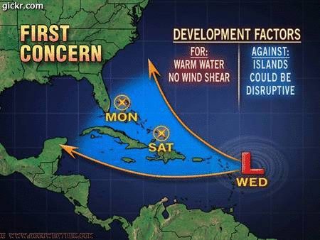
Now there is a spot in the Caribbean sea I think that TX to panhandle need to watch.

Okay that is my story and I am sticking to it.


PS I have known Derek Ortt from TWC days when he was in school. He does a good job. But you have to remember he is Human too. He is here to help us. Derek Thank Bud
Last edited by storms in NC on Tue Aug 12, 2008 3:33 pm, edited 1 time in total.
0 likes   

User avatar
Ivanhater
Storm2k Moderator
Storm2k Moderator
Posts: 11162
Age: 38
Joined: Fri Jul 01, 2005 8:25 am
Location: Pensacola

Re:

#1165 Postby Ivanhater » Tue Aug 12, 2008 3:27 pm

Derek Ortt wrote:recon very unimpressive

nothing to see folks


Yeah, to be expected though, Models dont start to develop this til another couple of days, thats when it looks to take off
0 likes   

User avatar
KWT
Category 5
Category 5
Posts: 31415
Joined: Tue Aug 17, 2004 11:02 am
Location: UK!!!

Re:

#1166 Postby KWT » Tue Aug 12, 2008 3:29 pm

Derek Ortt wrote:recon very unimpressive

nothing to see folks


Nothing to see....yet...I think thats the key word, I never thought recon would find anything at the surface given everything today, probably still a little while away from doing anything major.
0 likes   

User avatar
CalmBeforeStorm
Category 2
Category 2
Posts: 600
Age: 71
Joined: Tue Aug 10, 2004 7:55 pm
Location: Stuart, Florida

#1167 Postby CalmBeforeStorm » Tue Aug 12, 2008 3:29 pm

I think there's a very pronounced spin at around 17n-53w and even if it's only mid level it would only take some convection over it to allow it to get down to the surface. I think the chances of development are getting better.
0 likes   

User avatar
jrod
Military Member
Military Member
Posts: 546
Joined: Fri Jun 17, 2005 1:22 pm
Location: jacksonville, fl

Re: ATL: Invest 92L - Central Atlantic - TCFA issued

#1168 Postby jrod » Tue Aug 12, 2008 3:30 pm

It is just a long range model and I don't have any reason to trust it, I just find it interesting they have a cat1-2 'cane over Florida and another storm off of New England.
0 likes   

User avatar
KWT
Category 5
Category 5
Posts: 31415
Joined: Tue Aug 17, 2004 11:02 am
Location: UK!!!

#1169 Postby KWT » Tue Aug 12, 2008 3:33 pm

also lets not forget what Andrew did, in this location it was pretty weak if I remember rightly, indeed may have been 50-50 for it to get totally downgraded because of a lack of a LLC...so we know how quickly some things change though obviously I'm not forecasting another Andrew lol!
0 likes   

User avatar
cycloneye
Admin
Admin
Posts: 145452
Age: 68
Joined: Thu Oct 10, 2002 10:54 am
Location: San Juan, Puerto Rico

Re: ATL: Invest 92L - Central Atlantic - TCFA issued

#1170 Postby cycloneye » Tue Aug 12, 2008 3:34 pm

Remember Dolly folks,when nothing happened until a few days later.Recon went for the first time and did not found any LLC in 94L at that time,but in later flights,they found one and from there we know what happened.So lets calm down and wait for all the pieces to come together and in the next few days you will see Fay.
0 likes   

Honeyko

Re: Re:

#1171 Postby Honeyko » Tue Aug 12, 2008 3:35 pm

Derek Ortt wrote:recon very unimpressive
nothing to see folks
Well, recon clearly won't see much if they fly through only the top half of the storm.

NHC VIS floater depicts surface southwesterlies at about 13N
http://www.ssd.noaa.gov/goes/flt/t1/loop-vis.html

I haven't looked at the tape....would I be off in guessing they were chasing the decaying mid-level circulation up at 17N? The developing easterly surge is going to undercut that, and begin rolling a lower-latitude surface low out ahead of it (similar to old 99L).
0 likes   

User avatar
storms in NC
S2K Supporter
S2K Supporter
Posts: 2338
Joined: Thu Jul 28, 2005 2:58 pm
Location: Wallace,NC 40 miles NE of Wilm
Contact:

#1172 Postby storms in NC » Tue Aug 12, 2008 3:36 pm

I see it getting a nice out flow to it.

http://www.ssd.noaa.gov/goes/east/carb/loop-wv.html
0 likes   

User avatar
gatorcane
S2K Supporter
S2K Supporter
Posts: 23691
Age: 47
Joined: Sun Mar 13, 2005 3:54 pm
Location: Boca Raton, FL

#1173 Postby gatorcane » Tue Aug 12, 2008 3:37 pm

it still seems to be gaining some significant lattitude today I noticed. I really doubt it will track through the Caribbean at this time and it may miss the Leewards to the NE by about 50-100 miles.

What does everybody think about the gain in lattitude?
Last edited by gatorcane on Tue Aug 12, 2008 3:38 pm, edited 2 times in total.
0 likes   

User avatar
CalmBeforeStorm
Category 2
Category 2
Posts: 600
Age: 71
Joined: Tue Aug 10, 2004 7:55 pm
Location: Stuart, Florida

#1174 Postby CalmBeforeStorm » Tue Aug 12, 2008 3:38 pm

92L is more of threat as a tropical wave to the islands and the CONUS with current model trends then a Category 5 further east and predicted to recurve. That's why the concern even though it's not even a TD yet.
0 likes   

User avatar
Blown Away
S2K Supporter
S2K Supporter
Posts: 10147
Joined: Wed May 26, 2004 6:17 am

Re: ATL: Invest 92L - Central Atlantic - TCFA issued

#1175 Postby Blown Away » Tue Aug 12, 2008 3:38 pm

The dry air to the W and NW is slowly diminishing. Also, the cloud tops have been warming across the Atlantic at the same time, so it is not unique to 92L.

http://www.ssd.noaa.gov/goes/east/catl/loop-wv.html
0 likes   

User avatar
storms in NC
S2K Supporter
S2K Supporter
Posts: 2338
Joined: Thu Jul 28, 2005 2:58 pm
Location: Wallace,NC 40 miles NE of Wilm
Contact:

Re:

#1176 Postby storms in NC » Tue Aug 12, 2008 3:39 pm

gatorcane wrote:it still seems to be gaining some significant lattitude today I noticed. I really doubt it will track through the Caribbean at this time and it may miss the Leewards to the NE by about 50-150 miles.

What does everybody think about the gain in lattitude?


I think you may be right. If you look there is some in the Caribbean I would be watching if I were in on the Gulf
0 likes   

User avatar
hurricanefloyd5
Category 5
Category 5
Posts: 1659
Age: 44
Joined: Sun May 02, 2004 10:53 am
Location: Spartanburg
Contact:

Re:

#1177 Postby hurricanefloyd5 » Tue Aug 12, 2008 3:40 pm


WELL THIS LOOKS LIKE THIS STORM COULD VERY WELL AFFECT MY AREA AND I AM LOCATED IN THE ORLANDO AREA
0 likes   

HURRICANELONNY
Category 5
Category 5
Posts: 1383
Joined: Wed May 07, 2003 6:48 am
Location: HOLLYWOOD.FL

Re: ATL: Invest 92L - Central Atlantic - TCFA issued

#1178 Postby HURRICANELONNY » Tue Aug 12, 2008 3:41 pm

I don't see what the NHC sees. I see SSW shear that is tearing 92L apart. Moisture ahead of it is streaming North. Do they go by models or logic? I'd be surprised if 92L survives.
0 likes   

User avatar
cheezyWXguy
Category 5
Category 5
Posts: 6108
Joined: Mon Feb 13, 2006 12:29 am
Location: Dallas, TX

Re: Re:

#1179 Postby cheezyWXguy » Tue Aug 12, 2008 3:41 pm

hurricanefloyd5 wrote:

WELL THIS LOOKS LIKE THIS STORM COULD VERY WELL AFFECT MY AREA AND I AM LOCATED IN THE ORLANDO AREA

ZOMG...dont get your hopes up yet
0 likes   

Sanibel
Category 5
Category 5
Posts: 10375
Joined: Mon Aug 30, 2004 11:06 pm
Location: Offshore SW Florida

Re: ATL: Invest 92L - Central Atlantic - TCFA issued

#1180 Postby Sanibel » Tue Aug 12, 2008 3:41 pm

The "S" shape is obviously improved.

WNW right now on track north of islands (it seems).
0 likes   


Return to “2008”

Who is online

Users browsing this forum: No registered users and 1 guest