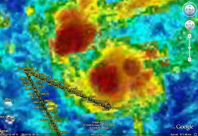
Aric Dunn wrote:my best position is 17.2n 60w
That maybe true for now, but it will either likely get pulled north into the convection, reform, or pull the convection southward.
Moderator: S2k Moderators


Aric Dunn wrote:my best position is 17.2n 60w
 That is priceless...Gives new meaning to the term "naked swirl"[/quote]
Aric Dunn wrote:my best position is 17.2n 60w


GeneratorPower wrote:Derek Ortt wrote:a little surprised to see the convection weakening so quickly this evening
Looks like it's bouncing back a little. What are your thoughts on whether this latest burst will die off tonight?
Time. Show me a "tinycane", and I'll show you a storm murdered by land or a with a tight recurve track (indicating upper-level shear). Otherwise, very powerful small storms turn into very powerful big storms fast.Zip wrote:What causes a storm, say Katrina, to grow so large in diameter, and a storm like the Great Labor Day Hurricane of 1935 to remain small and tightly wound?
Matt-hurricanewatcher wrote:Aric Dunn wrote:my best position is 17.2n 60w
Way to far west. The inflow is around 58-58.5 west with a south to north flow moving into the system. You can see a streamer of low clouds doing just that. Also some low clouds moving westward around the southern part. I feel the recon "could" find us a weak LLC for a upgrade. Now the nhc might feel on holding back on this.


GeneratorPower wrote:Looks like the 00z GFS doesn't really like 92L. Takes it as a closed low towards FL peninsula then kinda just drops it. The high building to the north holds strong on this run. Looks like that high will likely be in place. Uh oh.

txag2005 wrote:GeneratorPower wrote:Looks like the 00z GFS doesn't really like 92L. Takes it as a closed low towards FL peninsula then kinda just drops it. The high building to the north holds strong on this run. Looks like that high will likely be in place. Uh oh.
I am a newbie so i don't understand really, but does that mean this model doesn't really develop 92L?
Extremeweatherguy wrote:I would place the center closer to 59-59.5W, in between both of your estimates. It is a little hard to tell at night though without visible imagery.
Users browsing this forum: No registered users and 146 guests