Weird cyclones - Impressive cyclones

This is the general tropical discussion area. Anyone can take their shot at predicting a storms path.

Moderator: S2k Moderators

Forum rules

The posts in this forum are NOT official forecasts and should not be used as such. They are just the opinion of the poster and may or may not be backed by sound meteorological data. They are NOT endorsed by any professional institution or STORM2K. For official information, please refer to products from the National Hurricane Center and National Weather Service.

Help Support Storm2K
Message
Author
User avatar
vbhoutex
Storm2k Executive
Storm2k Executive
Posts: 29113
Age: 73
Joined: Wed Oct 09, 2002 11:31 pm
Location: Cypress, TX
Contact:

Re: Weird cyclones - Impressive cyclones

#221 Postby vbhoutex » Wed Aug 13, 2008 7:55 pm

Ad Novoxium wrote:For some reason, I loved Hurricane Frances of 1992's shape. Just one giant rainband.
Image

Looks like some weird animal curling in on itself. There is actually a name for these invertebrates which I can't remember(I see the head shape in the clouds nearest to the center).
0 likes   

Honeyko

Re: Weird cyclones - Impressive cyclones

#222 Postby Honeyko » Wed Aug 13, 2008 8:18 pm

vbhoutex wrote:Looks like some weird animal curling in on itself. There is actually a name for these invertebrates which I can't remember

Chambered Nautilus

Image Image
0 likes   

HurricaneRobert
Category 3
Category 3
Posts: 812
Joined: Fri May 18, 2007 9:31 pm

Re: Weird cyclones - Impressive cyclones

#223 Postby HurricaneRobert » Wed Aug 13, 2008 8:35 pm

Frances is also unusual because, if you look at the HURDAT, it goes from extratropical to a strong tropical storm. When it weakened it did the opposite. I don't see any transition phase in NHC's data.
0 likes   

User avatar
RattleMan
Category 5
Category 5
Posts: 1218
Joined: Wed Aug 24, 2005 7:14 pm
Location: Phoenix, AZ

Re: Weird cyclones - Impressive cyclones

#224 Postby RattleMan » Wed Aug 13, 2008 9:27 pm

HurricaneRobert wrote:Frances is also unusual because, if you look at the HURDAT, it goes from extratropical to a strong tropical storm. When it weakened it did the opposite. I don't see any transition phase in NHC's data.

Hmm? Unless I'm reading HURDAT wrong, it only goes extratropical at the end. Or maybe i'm not understanding what you mean?

Code: Select all

63710 08/25/2004 M=17  6 SNBR=1323 FRANCES     XING=1 SSS=2                     
63715 08/25*1110352  25 1009*1120368  30 1008*1130383  30 1007*1150398  35 1005*
63720 08/26*1190415  40 1003*1230429  45 1000*1280445  55  994*1330458  65  987*
63725 08/27*1370468  70  984*1420478  75  980*1470485  90  970*1540493 100  962*
63730 08/28*1590500 100  962*1660509 100  962*1720516 105  958*1770523 115  948*
63735 08/29*1810529 115  948*1840536 115  948*1860544 115  948*1880550 110  948*
63740 08/30*1890558 105  954*1900568 100  958*1920581 100  956*1940593 110  948*
63745 08/31*1960607 110  946*1980621 115  950*2000635 120  949*2030650 125  942*
63750 09/01*2060664 120  941*2100679 120  939*2140691 120  937*2180704 120  941*
63755 09/02*2220714 120  939*2270725 125  937*2320735 120  939*2380743 115  948*
63760 09/03*2420750 105  948*2470757 100  954*2530763  95  958*2570771  90  960*
63765 09/04*2600775  85  960*2640779  85  960*2680785  90  962*2680791  90  962*
63770 09/05*2700794  95  958*2720802  90  960*2740807  80  969*2780817  60  975*
63775 09/06*2810823  55  978*2860833  55  981*2920837  55  982*3010840  50  982*
63780 09/07*3100846  35  984*3150850  30  988*3200852  25  992*3250851  25  996*
63785 09/08*3340847  25  998*3430843  25 1000*3610832  25 1001*3780821  25 1002*
63790 09/09E3870813  25 1001E4050800  30 1001E4280777  35 1001E4430757  30 1002* <--- Extratropical 09/0000z
63795 09/10E4530733  25 1003E4620705  20 1004E4660673  20 1005E4720642  20 1005* <--- Still extratropical
0 likes   

User avatar
Chacor
Category 5
Category 5
Posts: 10229
Joined: Mon Oct 02, 2006 10:43 pm
Location: Singapore

#225 Postby Chacor » Wed Aug 13, 2008 10:15 pm

You're looking at the wrong Frances. The Frances being discussed is the one from 1992:

Code: Select all

55700 TS                                                                       
55705 10/22/1992 M=09  7 SNBR=1178 FRANCES     XING=0                           
55710 10/22*0000000   0    0*0000000   0    0E2630608  30 1009E2660612  40 1004*
55715 10/23E2710614  50  996*2770614  55  992*2830613  60  990*2870611  65  986*
55720 10/24*2900606  65  978*2960599  70  977*3060588  75  976*3210574  75  976*
55725 10/25*3380562  70  978*3570549  65  980*3770537  65  982*3960527  60  983*
55730 10/26*4140517  60  985*4320502  60  986*4480486  60  987*4600469  55  988*
55735 10/27*4700449  55  989E4760427  50  992E4800400  45  994E4800370  40  998*
55740 10/28E4800340  40 1002E4750310  35 1004E4700275  35 1002E4600240  35  999*
55745 10/29E4500200  40  999E4400160  35 1001E4350120  35 1002E4300090  30 1003*
55750 10/30E4300070  30 1002*0000000   0    0*0000000   0    0*0000000   0    0*
0 likes   

HurricaneBill
Category 5
Category 5
Posts: 3420
Joined: Sun Apr 11, 2004 5:51 pm
Location: East Longmeadow, MA, USA

Re: Weird cyclones - Impressive cyclones

#226 Postby HurricaneBill » Wed Aug 13, 2008 10:19 pm

I still think Hugo had one of the best buzzsaw appearances ever.

Here's Hugo at his Category 5 peak:

Image
0 likes   

User avatar
wxmann_91
Category 5
Category 5
Posts: 8013
Age: 34
Joined: Fri Jul 15, 2005 2:49 pm
Location: Southern California
Contact:

#227 Postby wxmann_91 » Thu Aug 14, 2008 3:17 am

Dvorak images like this one are rare, even in the WPAC:

STY Gay at its peak in 1992. It is speculated that Gay was possibly stronger than Tip. Per this study, ODT numbers for Gay as well as another cyclone possibly stronger than Tip, Angela in 1995, hovered between 8.3 and 8.7.

Image

(source: digital typhoon)
0 likes   

User avatar
wxmann_91
Category 5
Category 5
Posts: 8013
Age: 34
Joined: Fri Jul 15, 2005 2:49 pm
Location: Southern California
Contact:

#228 Postby wxmann_91 » Thu Aug 14, 2008 3:31 am

As an extension of the previous post, here's an image of Angela from 1995. Me personally, I think Gay was stronger just based on cloud tops and symmetry, although Angela's eye is smaller.

Image


Another cyclone mentioned in the study was Yuri of 1991, considered but eliminated. However, JMA estimated Yuri to be stronger than both Angela and Gay.

Image
0 likes   

Squarethecircle
Category 5
Category 5
Posts: 2165
Joined: Fri Oct 19, 2007 4:00 pm
Location: Fairfax, VA

#229 Postby Squarethecircle » Thu Aug 14, 2008 8:10 am

I've never thought Dvorak numbers mean much unless they've been thoroughly interpreted (and they're not even close to accurate in comparison to recon). Since no one can go back in time for those storms, Tip is still the strongest.

Note: I've also long thought that storms with lower T-numbers can appear more impressive than storms with higher ones. Dean at one point was a category 5 and looked much better than his T-numbers did. Monica was ridiculously impressive, but didn't get as high T-numbers as Gay or Angela.
1 likes   

User avatar
vbhoutex
Storm2k Executive
Storm2k Executive
Posts: 29113
Age: 73
Joined: Wed Oct 09, 2002 11:31 pm
Location: Cypress, TX
Contact:

Re: Weird cyclones - Impressive cyclones

#230 Postby vbhoutex » Thu Aug 14, 2008 9:01 am

Honeyko wrote:
vbhoutex wrote:Looks like some weird animal curling in on itself. There is actually a name for these invertebrates which I can't remember

Chambered Nautilus

Image Image


That wasn't what I was thinking of, but they definitely are similar to the picture. I think the name I was looking for is Hydra(I have weird eyes I guess).
0 likes   

arkestra
S2K Supporter
S2K Supporter
Posts: 88
Joined: Wed Jan 03, 2007 7:24 pm
Location: The Old Continent

Re: Weird cyclones - Impressive cyclones

#231 Postby arkestra » Thu Aug 14, 2008 12:44 pm

And here is the very famous, the great, the weird, the fighting Epsilon:

Image

Avila said: "There are no clear reasons, and I am not going to make one up, to explain the recent strengthening of Epsilon"

Epsilon! Case remains open.
0 likes   

Cyclone1
Category 5
Category 5
Posts: 2739
Age: 33
Joined: Tue Jun 12, 2007 12:03 pm
Location: Florida

#232 Postby Cyclone1 » Thu Aug 14, 2008 2:02 pm

Image

"IT WOULD BE NICE TO KNOW...SOMEDAY...WHY THIS HAPPENED."
0 likes   

User avatar
Calasanjy
Tropical Storm
Tropical Storm
Posts: 135
Age: 39
Joined: Thu Apr 06, 2006 3:16 pm
Location: PA

Re: Weird cyclones - Impressive cyclones

#233 Postby Calasanjy » Thu Aug 14, 2008 7:25 pm

I've always considered Tropical cyclone Katrina-Victor-Cindy of the 1997/1998 Australian/SWIO tropical cyclone season one of the most incredible solely because of the fact that it traversed four basins (Southwestern Pacific, Gulf of Carpentaria, Southeastern Indian Ocean, and Southwestern Indian Ocean). Tropical Cyclone 12P (Katrina) (S.S. Category 2) occurred simultaneously with the much more potent S.S. Category Five cyclones Ron (10P) and Susan (11P) in the South Pacific, then dissipated and redeveloped from the remnant low in the Perth AOR as TC Victor, then eventually crossed 90 degrees East into the La Reunion AOR and was briefly renamed Cindy (officially referred to in records as Tropical Cyclone 22S (Victor/Cindy)). Victor/Cindy achieved MSW of 90kts while located northwest of Australia.

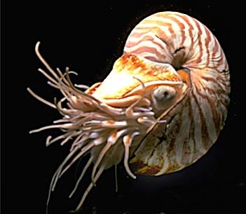
Visible image of TC Katrina:
Image

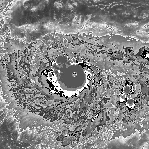
Visible image of TC Victor/Cindy:
Image

Track of TC Katrina:
Image

Track of TC Victor/Cindy:
Image
0 likes   

HurricaneBill
Category 5
Category 5
Posts: 3420
Joined: Sun Apr 11, 2004 5:51 pm
Location: East Longmeadow, MA, USA

Re: Weird cyclones - Impressive cyclones

#234 Postby HurricaneBill » Fri Aug 15, 2008 2:54 am

An unusual hurricane was Antje's hurricane in early September 1842. The storm was named after a ship that was damaged in the hurricane.

Antje's hurricane was unusual because of its path. The storm formed east of the Bahamas and moved due west into the southern Bahamas. Continuing on a due west course, the hurricane moved in between the Florida Keys and Cuba. Entering the Gulf of Mexico, the hurricane continued on a relatively due west course and eventually made landfall near Victoria, Mexico.

One of the possible explanations for the hurricane's due west track is an intense high pressure system over North America that prevented the hurricane from moving north.
0 likes   

User avatar
Ptarmigan
Category 5
Category 5
Posts: 5316
Joined: Wed Aug 16, 2006 9:06 pm

Re:

#235 Postby Ptarmigan » Fri Aug 15, 2008 2:25 pm

wxmann_91 wrote:Dvorak images like this one are rare, even in the WPAC:

STY Gay at its peak in 1992. It is speculated that Gay was possibly stronger than Tip. Per this study, ODT numbers for Gay as well as another cyclone possibly stronger than Tip, Angela in 1995, hovered between 8.3 and 8.7.

Image

(source: digital typhoon)


I read that STY Gay was very intense, but relatively small for a typhoon. I read it had a central pressure of 872 mb based on Dvorak. It would not surprise me if it had lower pressure, like around 865 mb.
0 likes   

User avatar
Ptarmigan
Category 5
Category 5
Posts: 5316
Joined: Wed Aug 16, 2006 9:06 pm

Re:

#236 Postby Ptarmigan » Fri Aug 15, 2008 2:26 pm

Squarethecircle wrote:I've never thought Dvorak numbers mean much unless they've been thoroughly interpreted (and they're not even close to accurate in comparison to recon). Since no one can go back in time for those storms, Tip is still the strongest.

Note: I've also long thought that storms with lower T-numbers can appear more impressive than storms with higher ones. Dean at one point was a category 5 and looked much better than his T-numbers did. Monica was ridiculously impressive, but didn't get as high T-numbers as Gay or Angela.


Dvorak number was WAY OFF with Hugo and Wilma. In fact the Hurricane Hunters nearly got killed in Hugo because of it. Wilma had a Dvorak scale of 6.0 to 6.5 at her peak of 882 mb and 185 mph. Dvorak is flawed in regards to pinhole eyes.
0 likes   

User avatar
Ptarmigan
Category 5
Category 5
Posts: 5316
Joined: Wed Aug 16, 2006 9:06 pm

Re:

#237 Postby Ptarmigan » Fri Aug 15, 2008 2:27 pm

Cyclone1 wrote:Image

"IT WOULD BE NICE TO KNOW...SOMEDAY...WHY THIS HAPPENED."


TS Allison of 2001. It was never suppose to form, yet it overcame it. If it had stayed over GOM longer, it would of been a hurricane.
0 likes   

Ad Novoxium
Category 1
Category 1
Posts: 348
Age: 35
Joined: Sat May 03, 2008 2:12 am

Re: Re:

#238 Postby Ad Novoxium » Fri Aug 15, 2008 2:46 pm

Ptarmigan wrote:
Cyclone1 wrote:Image

"IT WOULD BE NICE TO KNOW...SOMEDAY...WHY THIS HAPPENED."


TS Allison of 2001. It was never suppose to form, yet it overcame it. If it had stayed over GOM longer, it would of been a hurricane.


Huh? Those images were of Humberto. Plus, the quote's from Humberto's discussion. Were you adding Allison or was it a goof?
0 likes   

User avatar
Ptarmigan
Category 5
Category 5
Posts: 5316
Joined: Wed Aug 16, 2006 9:06 pm

Re: Re:

#239 Postby Ptarmigan » Fri Aug 15, 2008 5:44 pm

Ad Novoxium wrote:
Huh? Those images were of Humberto. Plus, the quote's from Humberto's discussion. Were you adding Allison or was it a goof?


Okay, it was a goof on my part for mistaking the image as Allison. :oops: However, I was addd Allison to it as well.
0 likes   

User avatar
Harry Cane
Tropical Low
Tropical Low
Posts: 33
Joined: Tue Aug 21, 2007 11:23 pm
Location: Asia
Contact:

Re: Weird cyclones - Impressive cyclones

#240 Postby Harry Cane » Fri Aug 15, 2008 10:35 pm

Sorry the weirdest one must have been Typhoon Vamei that formed 1 degree north of the equator end December 2001 in the South China Sea!

Image
0 likes   


Return to “Talkin' Tropics”

Who is online

Users browsing this forum: cycloneye, duilaslol, JtSmarts and 20 guests