ATL: Tropical Depression Fay

Moderator: S2k Moderators

Message
Author
NEXRAD
Category 1
Category 1
Posts: 370
Joined: Fri Jul 22, 2005 12:05 am
Location: South Florida

Re: ATL: Invest 92L in Western Atlantic

#3241 Postby NEXRAD » Thu Aug 14, 2008 10:10 pm

bvigal wrote:Ah, great to see and 'hear' you here, Jay! It's been a while!!


Thanks much, Bvigal - I've been busy with my university and research. Fortunately I'm between semesters for a couple of weeks, so I have a bit more time for the tropics. Nonetheless, I plan to keep watch on interesting storms and post commentary when I can here at S2K throughout the season.

- Jay
0 likes   

User avatar
deltadog03
Professional-Met
Professional-Met
Posts: 3580
Joined: Tue Jul 05, 2005 6:16 pm
Location: Macon, GA

Re: ATL: Invest 92L in Western Atlantic

#3242 Postby deltadog03 » Thu Aug 14, 2008 10:11 pm

:uarrow: Thats just north of the SFC low...(or suppose to be sfc low...) Thats why I think the big blob will start dieing off.
0 likes   

Kennethb
Category 2
Category 2
Posts: 506
Joined: Thu Aug 14, 2003 7:15 am
Location: Baton Rouge

#3243 Postby Kennethb » Thu Aug 14, 2008 10:11 pm

This system reminds me of one the eventually became I think Erika in 2003. There was a very similar appearance as 92L with incredible out flow over S. Florida. You would have thought there was a strong TS or even hurricane, but there was no surface reflection...yet. Eventually as it moved W to WSW, it developed over the GOM and went into S. Texas. And there was the system just a few weeks ago over S. Louisiana. We had good outflow and a mid level circulation while we had west winds at the surface.
0 likes   

User avatar
lrak
S2K Supporter
S2K Supporter
Posts: 1770
Age: 58
Joined: Thu Jun 21, 2007 2:48 pm
Location: Corpus Christi, TX

Re: ATL: Invest 92L in Western Atlantic

#3244 Postby lrak » Thu Aug 14, 2008 10:14 pm

http://radar.weather.gov/radar.php?rid= ... 1&loop=yes

Winds are NW on one side of PR and SE on the other.
0 likes   

User avatar
HURAKAN
Professional-Met
Professional-Met
Posts: 46086
Age: 38
Joined: Thu May 20, 2004 4:34 pm
Location: Key West, FL
Contact:

#3245 Postby HURAKAN » Thu Aug 14, 2008 10:15 pm

Image
0 likes   

User avatar
lrak
S2K Supporter
S2K Supporter
Posts: 1770
Age: 58
Joined: Thu Jun 21, 2007 2:48 pm
Location: Corpus Christi, TX

Re: ATL: Invest 92L in Western Atlantic

#3246 Postby lrak » Thu Aug 14, 2008 10:16 pm

I know I'm late in the game, but isn't this thing a lot futher South than anticipated?
0 likes   

User avatar
orion
S2K Supporter
S2K Supporter
Posts: 165
Joined: Mon Aug 02, 2004 5:44 pm
Location: Indian Harbour Beach, FL
Contact:

Re: ATL: Invest 92L in Western Atlantic

#3247 Postby orion » Thu Aug 14, 2008 10:17 pm

NEXRAD wrote:For what it's worth, I'm seeing a possible circulation on radar and with low level cloud features (thanks to shortwave IR) near 17.5N, 64.6W - or just south of Saint Croix. It's at extended radar range, so the resolution with that data is more mid-level than surface, and the shortwave IR information is particularly limited due to the obscuring MCS to the northeast of Saint Croix. Limited surface observations, however, really don't support that much.

- Jay


Jay... did you see that spot on radar earlier? It was like a blob broke away and took off southwest to the spot you are talking about. Not sure what it means, but was interesting to watch. It looked like even more circulation in that area than it does now. Maybe just an eddy or the radar playing tricks on our eyes. Surface obs definitely don't support anything there.

Just noticed that the winds (light as they are) at San Juan (SJNP4) just turned from out of the north to out of the WNW.
0 likes   

txag2005
Tropical Storm
Tropical Storm
Posts: 229
Joined: Thu Jul 17, 2008 1:16 am
Location: Houston, TX

Re: ATL: Invest 92L in Western Atlantic

#3248 Postby txag2005 » Thu Aug 14, 2008 10:17 pm

No 11PM statement from the NHC?
0 likes   

User avatar
Blown Away
S2K Supporter
S2K Supporter
Posts: 10165
Joined: Wed May 26, 2004 6:17 am

Re: ATL: Invest 92L in Western Atlantic

#3249 Postby Blown Away » Thu Aug 14, 2008 10:18 pm

deltadog03 wrote::uarrow: Thats just north of the SFC low...(or suppose to be sfc low...) Thats why I think the big blob will start dieing off.


Deltadog03 would you give us a summary on why almost all of the models show a sharp recurve just after 75W? What is your best estimate for 92L, recurve near 75W, landfall into SFL, up the EC towards Carolinas, or through SFL into EGOM?
0 likes   

User avatar
bvigal
S2K Supporter
S2K Supporter
Posts: 2276
Joined: Sun Jul 24, 2005 8:49 am
Location: British Virgin Islands
Contact:

Re:

#3250 Postby bvigal » Thu Aug 14, 2008 10:19 pm

HURAKAN wrote:Image
uh-oh, Hurakan, looks like the classic "boob stage" developing, LOL!
0 likes   

Sanibel
Category 5
Category 5
Posts: 10375
Joined: Mon Aug 30, 2004 11:06 pm
Location: Offshore SW Florida

Re: ATL: Invest 92L in Western Atlantic

#3251 Postby Sanibel » Thu Aug 14, 2008 10:20 pm

You can see the center spiral on the shortwave loop I posted clear as day. Pulling under the main convection on the - NE - side. Look at the loop. Headed for Puerto Rico on the north shore. That's why it hasn't shown up on Puerto Rican long range. Because it's just on the edge of range. This doesn't preclude a relocation. I'm interested in that new red dot on the NW edge.
0 likes   

Dean4Storms
S2K Supporter
S2K Supporter
Posts: 6358
Age: 62
Joined: Sun Aug 31, 2003 1:01 pm
Location: Miramar Bch. FL

Re: ATL: Invest 92L in Western Atlantic

#3252 Postby Dean4Storms » Thu Aug 14, 2008 10:20 pm

NEXRAD wrote:For what it's worth, I'm seeing a possible circulation on radar and with low level cloud features (thanks to shortwave IR) near 17.5N, 64.6W - or just south of Saint Croix. It's at extended radar range, so the resolution with that data is more mid-level than surface, and the shortwave IR information is particularly limited due to the obscuring MCS to the northeast of Saint Croix. Limited surface observations, however, really don't support that much.

- Jay


I went to Radarlab HD on Weathertap.com and saw the rotation you are seeing Jay. It is the only real rotation you can find on Radar and seems to be moving due west toward PR
0 likes   

User avatar
Blown Away
S2K Supporter
S2K Supporter
Posts: 10165
Joined: Wed May 26, 2004 6:17 am

Re: ATL: Invest 92L in Western Atlantic

#3253 Postby Blown Away » Thu Aug 14, 2008 10:20 pm

lrak wrote:I know I'm late in the game, but isn't this thing a lot futher South than anticipated?


No, 92L is skirting the N coast of PR just like the models showed.
0 likes   

Dean4Storms
S2K Supporter
S2K Supporter
Posts: 6358
Age: 62
Joined: Sun Aug 31, 2003 1:01 pm
Location: Miramar Bch. FL

Re: ATL: Invest 92L in Western Atlantic

#3254 Postby Dean4Storms » Thu Aug 14, 2008 10:25 pm

Blown_away wrote:
lrak wrote:I know I'm late in the game, but isn't this thing a lot futher South than anticipated?


No, 92L is skirting the N coast of PR just like the models showed.


Well part of 92L anyway.
0 likes   

NEXRAD
Category 1
Category 1
Posts: 370
Joined: Fri Jul 22, 2005 12:05 am
Location: South Florida

Re: ATL: Invest 92L in Western Atlantic

#3255 Postby NEXRAD » Thu Aug 14, 2008 10:26 pm

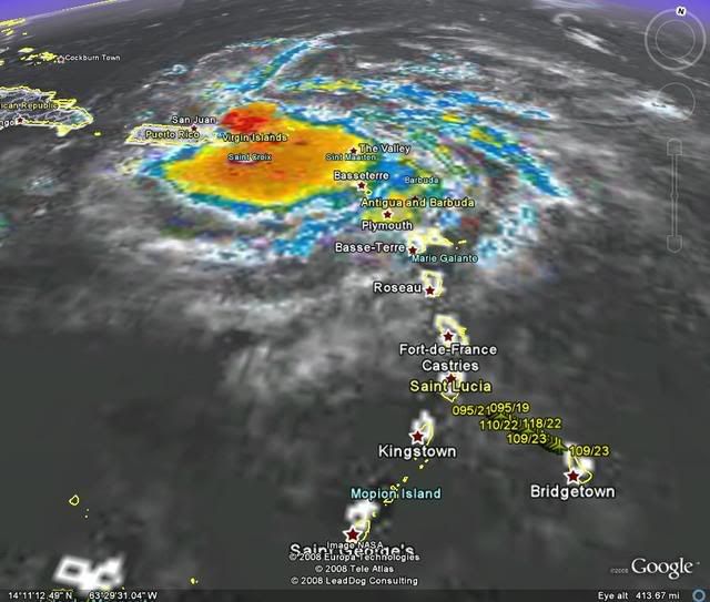
I suspect that my "apparent circulation" may be illusory. With longer range radar imagery, especially, small-scale occurences such as storm cell propagation or shallow cells dipping under the radar beam can make it seem like there's broader rotation when there really is no such happening. Hence why I always use the term "apparent" if I'm uncertain. BTW, I think that "apparent circulation" is better than this over-used "eddy" term. 8-)

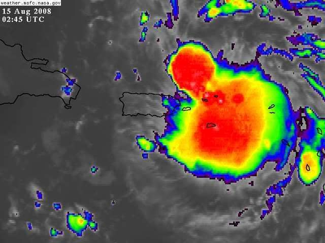
For the current convective situation, 92L is about to morph again. This time that new convective burst NE of Puerto Rico will likely become increasingly dominant, possibly elongating the disturbance NW to SE. It's hard to tell with IR imagery, but there might have been a recent outflow boundary emerging SE from the main convective region. If so, look for that MCS to diminish overnight with that more northern convective region becoming dominant. Obviously 92L is being driven by convective processes rather than any circulation core. So long the MCS's dissipate and reform without sustaining over a single area, the system is not really developing.

- Jay
0 likes   

User avatar
HURAKAN
Professional-Met
Professional-Met
Posts: 46086
Age: 38
Joined: Thu May 20, 2004 4:34 pm
Location: Key West, FL
Contact:

#3256 Postby HURAKAN » Thu Aug 14, 2008 10:26 pm

Image

NOAA plane en route.
0 likes   

Stormcenter
S2K Supporter
S2K Supporter
Posts: 6685
Joined: Wed Sep 03, 2003 11:27 am
Location: Houston, TX

Re: ATL: Invest 92L in Western Atlantic

#3257 Postby Stormcenter » Thu Aug 14, 2008 10:27 pm

Blown_away wrote:
lrak wrote:I know I'm late in the game, but isn't this thing a lot futher South than anticipated?


No, 92L is skirting the N coast of PR just like the models showed.


I guess Jim Cantore needs to retract what he said about 92L moving WSW.

http://www.ssd.noaa.gov/goes/flt/t1/loop-ir2.html
0 likes   

User avatar
alienstorm
Category 1
Category 1
Posts: 496
Joined: Tue Jul 31, 2007 1:29 pm
Location: Miami Fla western suburb

Re: ATL: Invest 92L in Western Atlantic

#3258 Postby alienstorm » Thu Aug 14, 2008 10:30 pm

If you look at the long range radar - the rotation points to an apparent center ene of San Juan, north of St< Thomas. Time will tell
0 likes   

User avatar
Blown Away
S2K Supporter
S2K Supporter
Posts: 10165
Joined: Wed May 26, 2004 6:17 am

Re: ATL: Invest 92L in Western Atlantic

#3259 Postby Blown Away » Thu Aug 14, 2008 10:30 pm

If the 92L's circulation center is near or just north of 18.4N/65.5W, it's on track to skirt or go just N of DR and maybe survive. Got to think the recent convection ball is over the circulation center.
http://www.ssd.noaa.gov/goes/flt/t1/loop-avn.html
0 likes   

MWatkins
S2K Supporter
S2K Supporter
Posts: 2574
Joined: Sat Oct 12, 2002 7:51 pm
Location: SE Florida
Contact:

Re: ATL: Invest 92L in Western Atlantic

#3260 Postby MWatkins » Thu Aug 14, 2008 10:30 pm

The more I look at long range radar out of San Juan...the more I think the center can't be south of the radar site. If there is one...it's either on the same latitude or perhaps even north of SJU.

Will be very interesting to see what recon finds...

It's blob-a-thon 5000 tonight. Follow the bouncing blob...all blobs all the time.

Will the next blob be the one that gets the low-level circulation?

Stay tuned!

MW
0 likes   


Return to “2008”

Who is online

Users browsing this forum: No registered users and 2 guests