ATL: Tropical Depression Fay

Moderator: S2k Moderators

Message
Author
User avatar
gatorcane
S2K Supporter
S2K Supporter
Posts: 23703
Age: 47
Joined: Sun Mar 13, 2005 3:54 pm
Location: Boca Raton, FL

Re: ATL: Invest 92L in Western Atlantic

#4161 Postby gatorcane » Fri Aug 15, 2008 2:10 pm

Air Force Met wrote:
fci wrote: AFM:
So if 92L tracks south of of DR what does that say to an expected future track?


I think the Fl panhandle or possibly as far west as AL could have issues. ...but somewhere along the west coast of FL would be my guess...


and keep in mind that is a BIG IF...its currently tracking right through the island as most model guidance has suggested.
0 likes   

weatherguru18

Re: ATL: Invest 92L in Western Atlantic

#4162 Postby weatherguru18 » Fri Aug 15, 2008 2:10 pm

It's WAY WAY early to call a landfall right now. Yesterday, some of you were certain this looked like and east coast storm because all the models said so.
0 likes   

Matt-hurricanewatcher

Re: ATL: Invest 92L in Western Atlantic

#4163 Postby Matt-hurricanewatcher » Fri Aug 15, 2008 2:11 pm

It is clear to me where the LLC is near 18.7/68.5. It appears to be just north of where the nhc puts it. Also You can also see that ob stations to the south have a westly wind. So it is a LLC. It is moving maybe 280 just off west.

http://www.cira.colostate.edu/cira/RAMM ... pical.html
0 likes   

User avatar
vbhoutex
Storm2k Executive
Storm2k Executive
Posts: 29133
Age: 74
Joined: Wed Oct 09, 2002 11:31 pm
Location: Cypress, TX
Contact:

Re: ATL: Invest 92L in Western Atlantic

#4164 Postby vbhoutex » Fri Aug 15, 2008 2:12 pm

Normandy wrote:I certainly did not expect this to head south of the DR, and it appears it might be doing so. This is one of the most poorly handled systems by the models in recent memory.


That is because there is not a strong LLCC to initialize from. Even witht the strong MLC, it is not necessarily going to be a good initialization since, as we have seen on the radar and sat loops they are not aligned at all.
0 likes   

User avatar
gatorcane
S2K Supporter
S2K Supporter
Posts: 23703
Age: 47
Joined: Sun Mar 13, 2005 3:54 pm
Location: Boca Raton, FL

#4165 Postby gatorcane » Fri Aug 15, 2008 2:13 pm

and using this link you can see the "trough" that should start affecting 92L over the next couple of days to give it that turn north. See it diving down over the East Coast of the US --- still can't see this making it too far west in the GOM....

http://www.ssd.noaa.gov/goes/east/nwatl/loop-wv.html
0 likes   

User avatar
ronjon
Category 5
Category 5
Posts: 4886
Joined: Fri Aug 19, 2005 5:17 pm
Location: Hernando Beach, FL

Re: ATL: Invest 92L in Western Atlantic

#4166 Postby ronjon » Fri Aug 15, 2008 2:13 pm

If the GFDL is to be believed, don't look for 92L to become a tropical cyclone for 24-36 hrs - it needs to move west of Hispanola before that model starts the development and pressure falls.
0 likes   

GreenSky
Tropical Storm
Tropical Storm
Posts: 109
Joined: Mon Aug 11, 2008 8:34 pm
Location: Land of Alex Jones!-Austin,TX

Re: ATL: Invest 92L in Western Atlantic

#4167 Postby GreenSky » Fri Aug 15, 2008 2:13 pm

I SURE hope the models don't ever shift towards NOLA or even here in TX....we've had more than our statistical average quota this year with Dolly and Edouard.
0 likes   

Stratosphere747
Category 5
Category 5
Posts: 3772
Joined: Thu Sep 11, 2003 8:34 pm
Location: Surfside Beach/Freeport Tx
Contact:

#4168 Postby Stratosphere747 » Fri Aug 15, 2008 2:13 pm

15/1745 UTC 18.1N 68.6W T2.5/2.5 92L
0 likes   

txag2005
Tropical Storm
Tropical Storm
Posts: 229
Joined: Thu Jul 17, 2008 1:16 am
Location: Houston, TX

Re: ATL: Invest 92L in Western Atlantic

#4169 Postby txag2005 » Fri Aug 15, 2008 2:14 pm

Is the general consensus still that this thing will form?
0 likes   

jlauderdal
S2K Supporter
S2K Supporter
Posts: 7240
Joined: Wed May 19, 2004 5:46 am
Location: NE Fort Lauderdale
Contact:

Re: ATL: Invest 92L in Western Atlantic

#4170 Postby jlauderdal » Fri Aug 15, 2008 2:14 pm

seaswing wrote:
physicx07 wrote:I think it's kind of funny too. Particularly the news reporters getting so uppity when it's 4 days away from FL anyway.

Stormcenter wrote:I'm sorry if I offend anyone but this is becoming comical.
We some who think the "center" is north of DR and others
who think it's south and then there are the ones who can't
find any center or don't care because it still "looks" so good it should be a TS already.
All of that in itself should tell you a lot about the current state of 92L.
There is a ton of smoke but NO fire.


Well, as far as preparation goes... 4 days away is not really that far away!


its plenty for the people that do what they should before the season starts, if 2 days isnt enough than you will never be prepared
0 likes   

GreenSky
Tropical Storm
Tropical Storm
Posts: 109
Joined: Mon Aug 11, 2008 8:34 pm
Location: Land of Alex Jones!-Austin,TX

Re: ATL: Invest 92L in Western Atlantic

#4171 Postby GreenSky » Fri Aug 15, 2008 2:15 pm

txag2005 wrote:Is the general consensus still that this thing will form?


Who knows? 92L has been one of the most frustratingly confusing systems to track. I give up!
0 likes   

Stormcenter
S2K Supporter
S2K Supporter
Posts: 6685
Joined: Wed Sep 03, 2003 11:27 am
Location: Houston, TX

Re: ATL: Invest 92L in Western Atlantic

#4172 Postby Stormcenter » Fri Aug 15, 2008 2:16 pm

GreenSky wrote:I SURE hope the models don't ever shift towards NOLA or even here in TX....we've had more than our statistical average quota this year with Dolly and Edouard.


Just say no to Texas or La. :D
0 likes   

User avatar
HURAKAN
Professional-Met
Professional-Met
Posts: 46086
Age: 38
Joined: Thu May 20, 2004 4:34 pm
Location: Key West, FL
Contact:

#4173 Postby HURAKAN » Fri Aug 15, 2008 2:16 pm

Image
0 likes   

User avatar
Ivanhater
Storm2k Moderator
Storm2k Moderator
Posts: 11165
Age: 38
Joined: Fri Jul 01, 2005 8:25 am
Location: Pensacola

Re: ATL: Invest 92L in Western Atlantic

#4174 Postby Ivanhater » Fri Aug 15, 2008 2:18 pm

Derek's new blog on Pensacola News Journal..

http://www.pnj.com/apps/pbcs.dll/sectio ... ersonaDest
0 likes   

User avatar
vbhoutex
Storm2k Executive
Storm2k Executive
Posts: 29133
Age: 74
Joined: Wed Oct 09, 2002 11:31 pm
Location: Cypress, TX
Contact:

Re: ATL: Invest 92L in Western Atlantic

#4175 Postby vbhoutex » Fri Aug 15, 2008 2:18 pm

Matt-hurricanewatcher wrote:It is clear to me where the LLC is near 18.7/68.5. It appears to be just north of where the nhc puts it. Also You can also see that ob stations to the south have a westly wind. So it is a LLC. It is moving maybe 280 just off west.

http://www.cira.colostate.edu/cira/RAMM ... pical.html


I have to disagree with you Matt. What I see is a definite strong MLC over the island and a POSSIBLE decaying elongated NW to SE or NNW to SSE LLCC.

This is undoubtably one of the toughest systems I have ever tracked as far as what the heck it is or is going to do!!!! :double: :double:
0 likes   

weatherguru18

Re: ATL: Invest 92L in Western Atlantic

#4176 Postby weatherguru18 » Fri Aug 15, 2008 2:18 pm

Stormcenter wrote:
GreenSky wrote:I SURE hope the models don't ever shift towards NOLA or even here in TX....we've had more than our statistical average quota this year with Dolly and Edouard.


Just say no to Texas or La. :D


At this time, I find it hard to believe it would make it this far west....but who knows. If I lived anywhere from Mobile to Tampa, I'd be vigilant. I'd be headed to WalMart right now. Of course I still have water from freakin' Rita! Actually I don't, but I do have other supplies from that storm that I never used. Sorry Ivanhater, we've all been there...well, most of us.
0 likes   

User avatar
Bocadude85
Category 5
Category 5
Posts: 2990
Age: 39
Joined: Mon Apr 18, 2005 2:20 pm
Location: Honolulu,Hi

Re: ATL: Invest 92L in Western Atlantic

#4177 Postby Bocadude85 » Fri Aug 15, 2008 2:19 pm

weatherguru18 wrote:
cheezyWXguy wrote:
weatherguru18 wrote:Certainly looks south of DR to me. If you look at the Sat pic closely, it appears to have taken a wsw jog...

Its not and I have absolutely no idea what youre talking about.


http://www.goes.noaa.gov/HURRLOOPS/huirloop.html

I think your the one that needs to double check. Any LLC, like Derek said, is due east of the DR...and IMO moving slightly south of due west.


Look at this loop you can clearly see it moving wnw not wsw

http://rammb.cira.colostate.edu/ramsdis ... is_floater
0 likes   

User avatar
Blown Away
S2K Supporter
S2K Supporter
Posts: 10252
Joined: Wed May 26, 2004 6:17 am

Re: ATL: Invest 92L in Western Atlantic

#4178 Postby Blown Away » Fri Aug 15, 2008 2:19 pm

cycloneye wrote:Best track at 18:00 UTC:

AL, 92, 2008081518, , BEST, 0, 186N, 686W, 30, 1009, DB, 34, NEQ,

Position is inland.


Is this the official position!!
0 likes   

User avatar
vbhoutex
Storm2k Executive
Storm2k Executive
Posts: 29133
Age: 74
Joined: Wed Oct 09, 2002 11:31 pm
Location: Cypress, TX
Contact:

Re: ATL: Invest 92L in Western Atlantic

#4179 Postby vbhoutex » Fri Aug 15, 2008 2:20 pm

Stormcenter wrote:
GreenSky wrote:I SURE hope the models don't ever shift towards NOLA or even here in TX....we've had more than our statistical average quota this year with Dolly and Edouard.


Just say no to Texas or La. :D

I third that motion!!!!! Go FISH!!!!!
0 likes   

User avatar
storms in NC
S2K Supporter
S2K Supporter
Posts: 2338
Joined: Thu Jul 28, 2005 2:58 pm
Location: Wallace,NC 40 miles NE of Wilm
Contact:

#4180 Postby storms in NC » Fri Aug 15, 2008 2:21 pm

Atlantic Graphical Tropical Weather Outlook
--------------------------------------------------------------------------------
This experimental product is updated at approximately 2 AM, 8 AM, 2 PM, and 8 PM EDT
Place your mouse cursor over areas of interest for more information


ZCZC MIATWOAT ALL
TTAA00 KNHC DDHHMM
TROPICAL WEATHER OUTLOOK
NWS TPC/NATIONAL HURRICANE CENTER MIAMI FL
200 PM EDT FRI AUG 15 2008

FOR THE NORTH ATLANTIC...CARIBBEAN SEA AND THE GULF OF MEXICO...

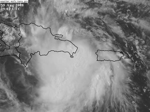
1. SURFACE OBSERVATIONS AND RADAR DATA FROM PUERTO RICO AND THE
DOMINICAN REPUBLIC SHOW THAT THE CENTER OF THE LOW PRESSURE AREA IS
MOVING INLAND OVER THE DOMINICAN REPUBLIC. THIS SYSTEM IS
GRADUALLY BECOMING BETTER ORGANIZED...AND NOAA AND AIR FORCE
RESERVE HURRICANE HUNTER AIRCRAFT ARE CURRENTLY INVESTIGATING IT.
A TROPICAL DEPRESSION COULD FORM AT ANY TIME DURING THE NEXT DAY OR
TWO...ALTHOUGH WHEN AND WHERE A DEPRESSION MIGHT FORM IS UNCERTAIN
DUE TO INTERACTIONS WITH THE LAND MASS OF HISPANIOLA. HEAVY RAINS
AND GUSTY WINDS ARE EXPECTED OVER PORTIONS OF PUERTO RICO...THE
DOMINICAN REPUBLIC...AND HAITI...AND ARE EXPECTED TO SPREAD OVER
EASTERN CUBA AND THE SOUTHEASTERN BAHAMAS DURING THE NEXT DAY OR
TWO. INTERESTS IN THESE AREAS...AS WELL AS THE REMAINDER OF
CUBA...THE REMAINDER OF THE BAHAMAS...SOUTHERN FLORIDA...AND
JAMAICA...SHOULD MONITOR THE PROGRESS OF THIS SYSTEM.
0 likes   


Return to “2008”

Who is online

Users browsing this forum: No registered users and 39 guests