ATL: Tropical Depression Fay

Moderator: S2k Moderators

Message
Author
Air Force Met
Military Met
Military Met
Posts: 4372
Age: 56
Joined: Tue Jul 08, 2003 9:30 am
Location: Roan Mountain, TN

Re:

#4561 Postby Air Force Met » Fri Aug 15, 2008 7:58 pm

RL3AO wrote:Anyone else worried about Fays LLC redeveloping off the southern coast?

Also, the NHC will have to forecast a cane at 11 because of the GFDL/HWRF.


Those runs are bad news. A cat 4 on that angle puts about a 27' surge into the St Marks area.

Really hope that doesn't verify.
0 likes   

User avatar
timeflow
Tropical Depression
Tropical Depression
Posts: 99
Age: 53
Joined: Tue Jul 05, 2005 5:48 pm
Location: Orlando, FL
Contact:

#4562 Postby timeflow » Fri Aug 15, 2008 8:00 pm

This was the storm I was trying to remember all day... Chris lost itself in the mountains of Hispanola or Cuba if I recall correctly. Does anyone remember? Who knows what will come of Fay, will she have a date with a similar fate? Very suspenseful situation.
0 likes   

User avatar
HURAKAN
Professional-Met
Professional-Met
Posts: 46086
Age: 38
Joined: Thu May 20, 2004 4:34 pm
Location: Key West, FL
Contact:

#4563 Postby HURAKAN » Fri Aug 15, 2008 8:01 pm

Image
0 likes   

Rainband

Re: Re:

#4564 Postby Rainband » Fri Aug 15, 2008 8:01 pm

Air Force Met wrote:
RL3AO wrote:Anyone else worried about Fays LLC redeveloping off the southern coast?

Also, the NHC will have to forecast a cane at 11 because of the GFDL/HWRF.


Those runs are bad news. A cat 4 on that angle puts about a 27' surge into the St Marks area.

Really hope that doesn't verify.
Me either too close for comfort
0 likes   

User avatar
HURAKAN
Professional-Met
Professional-Met
Posts: 46086
Age: 38
Joined: Thu May 20, 2004 4:34 pm
Location: Key West, FL
Contact:

#4565 Postby HURAKAN » Fri Aug 15, 2008 8:02 pm

Chris was killed by mid-level shear. Its dead had nothing to do with the mountains.

Image
0 likes   

User avatar
SWFLA_CANE
Tropical Storm
Tropical Storm
Posts: 196
Joined: Tue Jun 06, 2006 6:41 pm
Location: Naples, Florida

Re: ATL: Tropical Storm Fay

#4566 Postby SWFLA_CANE » Fri Aug 15, 2008 8:04 pm

I would not put to much stock in the models just yet. When it clears land and turn N then we will have a better landfall idea. Till then the models will jump east and west. Everyone from SFLA to Alabama should be ready for anything from a TS to a major.
0 likes   

User avatar
Noles2006
Category 1
Category 1
Posts: 424
Joined: Thu Jun 08, 2006 9:57 am
Location: Tallahassee, Florida
Contact:

Re: Re:

#4567 Postby Noles2006 » Fri Aug 15, 2008 8:04 pm

Air Force Met wrote:
RL3AO wrote:Anyone else worried about Fays LLC redeveloping off the southern coast?

Also, the NHC will have to forecast a cane at 11 because of the GFDL/HWRF.


Those runs are bad news. A cat 4 on that angle puts about a 27' surge into the St Marks area.

Really hope that doesn't verify.


Yeah, that's no joke.

Dennis gave us a surge of 10-12 feet... and he made landfall 200+ miles away...
0 likes   

User avatar
D3m3NT3DVoRT3X
Tropical Low
Tropical Low
Posts: 31
Age: 47
Joined: Thu Aug 16, 2007 6:37 pm
Location: The Burg < FL

Re: ATL: Tropical Storm Fay

#4568 Postby D3m3NT3DVoRT3X » Fri Aug 15, 2008 8:05 pm

yeah real close .. i can see work next week is going to be fun ... moving all our work computers and servers whoopy .. like i feel like comming into that next week at work GO Away Fay!

Oh yeah Go Rays!
0 likes   

User avatar
artist
Category 5
Category 5
Posts: 9792
Joined: Mon Jun 06, 2005 3:26 pm
Location: West Palm

Re: ATL: Tropical Storm Fay

#4569 Postby artist » Fri Aug 15, 2008 8:06 pm

interesting read on Jeanne and the synoptic set up when she was crossing Hispaniola.
On September 17, while it was over Hispaniola, the National Hurricane Center issued a forecast that predicted Jeanne to make landfall near Savannah, Georgia in about five days. However, the forecast noted uncertainty in regards to the steering currents, which depended on the movement of the remnants of Hurricane Ivan and a ridge building behind it.[19] After it left the nation as a tropical depression, the original center of circulation tracked westward away from the convection and dissipated. However, a new circulation developed closer to the convection, and Jeanne regained tropical storm status on September 18. By then, the mid-level circulation associated with Hurricane Ivan had combined with a trough to weaken the ridge located across the western Atlantic Ocean; this caused Jeanne to track northward through the Turks and Caicos Islands.[1]


http://en.wikipedia.org/wiki/Meteorolog ... ane_Jeanne
0 likes   

JPmia
S2K Supporter
S2K Supporter
Posts: 1070
Joined: Thu Jun 03, 2004 11:01 pm
Location: Fort Lauderdale, FL

Re: Re:

#4570 Postby JPmia » Fri Aug 15, 2008 8:06 pm

Air Force Met wrote:
RL3AO wrote:Anyone else worried about Fays LLC redeveloping off the southern coast?

Also, the NHC will have to forecast a cane at 11 because of the GFDL/HWRF.


Those runs are bad news. A cat 4 on that angle puts about a 27' surge into the St Marks area.

Really hope that doesn't verify.


St. Marks and most of Wachulla County...I know that area well...FSU grad here...as I said in another thread...that landfall angle would be catastrophic for the Big Bend...and the Florida Dept Emerg Mgmt would get to test out their hardened building as well.
0 likes   

User avatar
Aquawind
Category 5
Category 5
Posts: 6714
Age: 62
Joined: Mon Jun 16, 2003 10:41 pm
Location: Salisbury, NC
Contact:

#4571 Postby Aquawind » Fri Aug 15, 2008 8:07 pm

It tend to think it will shift west and further into the gulf unfortunately. It's within 10 miles of my house now and the best scenario looks like a imeadiate ride into the swamp and through the middle of the state..keep it over land. Looks like we owe a little thanks to the islands again at least down here as it just gets cranking again as it passes by me.
0 likes   

User avatar
LSU2001
S2K Supporter
S2K Supporter
Posts: 1711
Age: 58
Joined: Sat Sep 11, 2004 11:01 pm
Location: Cut Off, Louisiana

Re: ATL: Tropical Storm Fay

#4572 Postby LSU2001 » Fri Aug 15, 2008 8:08 pm

interesting read on Jeanne and the synoptic set up when she was crossing Hispaniola.
Quote:
On September 17, while it was over Hispaniola, the National Hurricane Center issued a forecast that predicted Jeanne to make landfall near Savannah, Georgia in about five days. However, the forecast noted uncertainty in regards to the steering currents, which depended on the movement of the remnants of Hurricane Ivan and a ridge building behind it.[19] After it left the nation as a tropical depression, the original center of circulation tracked westward away from the convection and dissipated. However, a new circulation developed closer to the convection, and Jeanne regained tropical storm status on September 18. By then, the mid-level circulation associated with Hurricane Ivan had combined with a trough to weaken the ridge located across the western Atlantic Ocean; this caused Jeanne to track northward through the Turks and Caicos Islands.[1]


http://en.wikipedia.org/wiki/Meteorolog ... ane_Jeanne


Yeah, then a piece of energy associated with Ivan emerged off the east coast and was renamed Ivan and he looped all the way around into the gulf and made final landfall somewhere around the TX/La Border. Strange, Strange story. LOL
Tim
0 likes   

JonathanBelles
Professional-Met
Professional-Met
Posts: 11430
Age: 35
Joined: Sat Dec 24, 2005 9:00 pm
Location: School: Florida State University (Tallahassee, FL) Home: St. Petersburg, Florida
Contact:

Re: TS Fay Personal forecasts

#4573 Postby JonathanBelles » Fri Aug 15, 2008 8:13 pm

The posts in this forum are NOT official forecast and should not be used as such. They are just the opinion of the poster and may or may not be backed by sound meteorological data. They are NOT endorsed by any professional institution or storm2k.org. For official information, please refer to the NHC and NWS products.

Advisory 081508

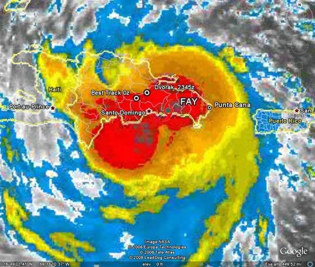
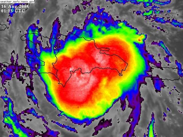
Tropical Storm Fay is moving westward through the Dominican Republic. .

Image

Near Santo Domingo, Dominican Republic….Tropical Storm Fay. Hurricane Hunters found a closed center of circulation and winds of 45 mph earlier today, allowing the naming of Fay. Fay is moving westward through the mountains of Hispaniola.

Fay is likely to have a very erratic future because of its own disorganization and the mountains of Hispaniola. I think that if the lower level circulation falls apart it will reform to the south of the island.

Intensity will be controlled by how much land Fay travels over. The less land interaction the stronger she will get. Right now I believe intensity will stay as a Tropical Storm until it makes it into the Gulf of Mexico. Hispaniola, Cuba, the southern Bahamas, and Florida will all experience tropical storm force winds. I cannot leave out the possibility of a hurricane in the gulf of Mexico, but for right now I think that it will be at 70mph at landfall on the west coast of Florida.

Depending on any reformations, the track will pass through southern Haiti, then central Cuba. These two places will dictate how strong Fay will get. From north Central Cuba, Fay will move into the southeastern Gulf of Mexico where sea surface temperatures are between 86 and 90°F, which is plenty warm for intensification. Effects will be widespread on the west coast of Florida. What those effects are remain to be seen.

There is a Tropical Storm Warning issued for the northern coast of Hispaniola, the southern coast of Cuba and the southern Bahamas. Those in this area should expect tropical storm force winds in the next 24 hours increasing with altitude. Rainfall especially in Hispaniola will be heavy because of the mountainous terrain. 3-5” will be possible in the lower areas in Hispaniola and in Cuba, and up to a foot of rain is possible in the highest areas of Hispaniola. This may cause deadly mudslides. A Tropical Storm Watch is issued in northeastern Cuba and in the middle Bahamas. Those here should expect tropical storm conditions in the next 36 hours.

Those in all of the northern and western Caribbean and in Florida should be watching and preparing for a tropical storm to a minimal hurricane.

Fact789-Jonathan
0 likes   

User avatar
Just Joshing You
Category 2
Category 2
Posts: 512
Joined: Sat Nov 03, 2007 10:29 am
Location: Nova Scotia

#4574 Postby Just Joshing You » Fri Aug 15, 2008 8:14 pm

The only problem with the GFDL run is it was initialized too far south, so I doubt (if it all came true) it would effect that exact area.
0 likes   

Air Force Met
Military Met
Military Met
Posts: 4372
Age: 56
Joined: Tue Jul 08, 2003 9:30 am
Location: Roan Mountain, TN

Re:

#4575 Postby Air Force Met » Fri Aug 15, 2008 8:21 pm

extradited wrote:The only problem with the GFDL run is it was initialized too far south, so I doubt (if it all came true) it would effect that exact area.


Not really...

0 Hr 18.3N 68.7W 275./12.0

That's about 12 miles south of where it was at 21z...and pretty close to where it was at 18z.

It wasn't sitting on the north coast of the DR.
0 likes   

User avatar
Chacor
Category 5
Category 5
Posts: 10229
Joined: Mon Oct 02, 2006 10:43 pm
Location: Singapore

#4576 Postby Chacor » Fri Aug 15, 2008 8:22 pm

A reminder that you can have a go at the prediction contest for TS Fay in the forecasting contest forum.
0 likes   

User avatar
Just Joshing You
Category 2
Category 2
Posts: 512
Joined: Sat Nov 03, 2007 10:29 am
Location: Nova Scotia

#4577 Postby Just Joshing You » Fri Aug 15, 2008 8:22 pm

Yea sorry, I just put my glasses on and it looked further away on the graphic than it actually was. But still. 12 miles south is still significant!!!!!!!! admit that huh!?!?!?! lol

I'm joking though.
0 likes   

User avatar
Extremeweatherguy
Category 5
Category 5
Posts: 11095
Joined: Mon Oct 10, 2005 8:13 pm
Location: Florida

#4578 Postby Extremeweatherguy » Fri Aug 15, 2008 8:27 pm

Santa Domingo is reporting very high winds right now! The following link features a live wind report that is updated every few seconds from the city..

http://www.wunderground.com/global/stations/78486.html

So far, I have seen the sustained speeds reach as high as 47mph! :eek:
Last edited by Extremeweatherguy on Fri Aug 15, 2008 8:29 pm, edited 1 time in total.
0 likes   

jaxfladude
Category 5
Category 5
Posts: 1249
Joined: Wed Aug 24, 2005 9:36 pm
Location: Jacksonville, Fla

Re: ATL: Tropical Storm Fay

#4579 Postby jaxfladude » Fri Aug 15, 2008 8:29 pm

I am still worried about being in the dirty side of Fay if the track stays somewhat like the NHC 5pm projection....
0 likes   

User avatar
HURAKAN
Professional-Met
Professional-Met
Posts: 46086
Age: 38
Joined: Thu May 20, 2004 4:34 pm
Location: Key West, FL
Contact:

#4580 Postby HURAKAN » Fri Aug 15, 2008 8:29 pm

Image
0 likes   


Return to “2008”

Who is online

Users browsing this forum: No registered users and 36 guests