Within 3 hours of it moving into that little gulf then into the caribbean afterwards.
Already convection is firing.
ATL: Tropical Depression Fay
Moderator: S2k Moderators
-
AdamFirst

- S2K Supporter

- Posts: 2490
- Age: 36
- Joined: Thu Aug 14, 2008 10:54 am
- Location: Port Saint Lucie, FL
*yawn* Good morning everyone.
Seems like this powder keg that we call Fay is ready to blow up. With certain models starting to shift east, I wouldn't be surprised if this thing is closer to the East Coast than expected. Canadian and Euro models suggest East Coast impacts now.
I work at Publix. I'll tell you how things are going on in our neighborhood later today.
0 likes
-
Toyota Thundra
- Tropical Low

- Posts: 33
- Joined: Sat Aug 16, 2008 1:35 am
- Location: Riverview FL

I think the NHC is doing a great job with the forecasted track so far, I am glad that they did not moved west earlier before the 00z euro model came out. The only thing that I disagree is with the forecasted strength, Fay could really get going once she emerges back over the most energy potent waters of the basin in a few hours if there is some kind of tight LLC still left.
She is starting to get within Cuban radar range.

She is starting to get within Cuban radar range.
0 likes
-
Toyota Thundra
- Tropical Low
- Posts: 33
- Joined: Sat Aug 16, 2008 1:35 am
- Location: Riverview FL
Re: ATL: Tropical Storm Fay
When she comes off the coast in three hours or so.... It may determine a more definitive track, as the high mountains are making it less than easy to pinpoint a true COC... 29-30* Waters breed beastly storms.... It is wait and see for now I guess 
0 likes


Re: ATL: Tropical Storm Fay
Sounds like the RECON crew had a rough time last night. Let's give these brave souls our thanks for the great job they do!
EVEN THOUGH WE CANNOT DETERMINE EXACTLY WHERE THE CENTER OF FAY IS
LOCATED...SATELLITE IMAGERY AND DATA FROM AN AIR FORCE RECONNAISSANCE AIRCRAFT SUGGEST IT IS STILL INLAND...OVER SOUTH-CENTRAL HISPANIOLA NEAR THE BORDER BETWEEN THE DOMINICAN REPUBLIC AND HAITI. THE AIR FORCE PLANE CIRCUMNAVIGATED THE ENTIRE
ISLAND OF HISPANIOLA DURING THE PAST FEW HOURS...ENDURING SOME RATHER TURBULENT CONDITIONS...ESPECIALLY WITHIN THE STRONGEST
THUNDERSTORMS NEAR THE SOUTHERN COAST...AND WE APPRECIATE THE HARD WORK OF THE CREW.
0 likes


-
Matt-hurricanewatcher
Re: ATL: Tropical Storm Fay
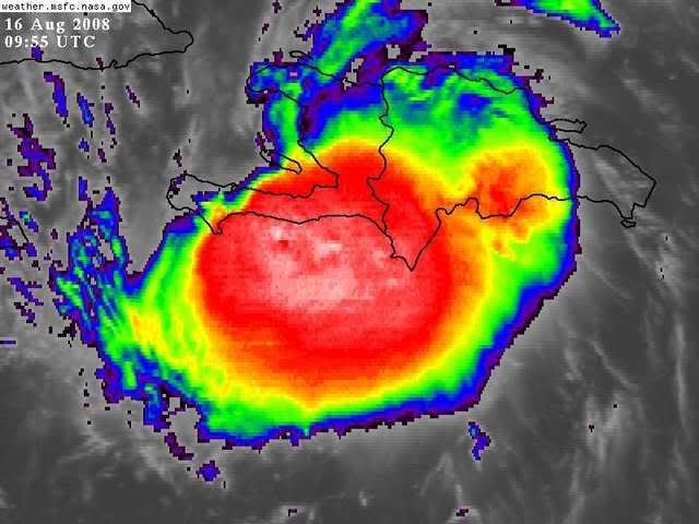
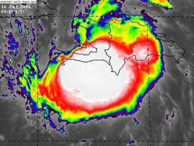
BOOM!!!! Convection forming over the LLC.
The LLC appears to have made it to that small gulf near 18.8/72.3. It only gets better for it from here on intil 36 hours.
The LLC appears to have made it to that small gulf near 18.8/72.3. It only gets better for it from here on intil 36 hours.
0 likes
-
Toyota Thundra
- Tropical Low
- Posts: 33
- Joined: Sat Aug 16, 2008 1:35 am
- Location: Riverview FL
Re: ATL: Tropical Storm Fay
I think we may have a stronger forecast in the future... Things are about to get real interesting. COME ON DAYLIGHT!!! 
0 likes
Re: ATL: Tropical Storm Fay
Matt-hurricanewatcher wrote:BOOM!!!! Convection forming over the LLC.
The LLC appears to have made it to that small gulf near 18.8/72.3. It only gets better for it from here on intil 36 hours.
It appears that way by looking at the Cuban radar

0 likes
-
sfwx

- Category 1

- Posts: 371
- Age: 60
- Joined: Thu Sep 04, 2003 1:53 pm
- Location: Rural St. Lucie County, Fl
Re: ATL: Tropical Storm Fay
Special Weather Statement
SPECIAL WEATHER STATEMENT
NATIONAL WEATHER SERVICE MIAMI FL
600 AM EDT SAT AUG 16 2008
...TROPICAL STORM FAY MOVING OVER HAITI...
...SOUTH FLORIDA SHOULD CONTINUE TO CLOSELY MONITOR FAY...
TROPICAL STORM FAY CONTINUES TO MOVE WEST OVER THE HAITI AT 14 MPH.
FAY WILL CONTINUE TO MOVE WEST ACROSS THE WATERS BETWEEN HISPANIOLA
LATER TODAY AND THEN NORTHWEST ALONG THE SOUTHERN CUBAN COAST ON
SUNDAY. THE OFFICIAL FORECAST TRACK INDICATES AN EVENTUAL NORTHWARD
TURN SUNDAY NIGHT, WHICH WOULD BRING THE CENTER OF FAY OVER THE
STRAITS OF FLORIDA OR THE EXTREME SOUTHEAST GULF OF MEXICO MONDAY
NIGHT INTO TUESDAY.
THIS TRACK REPRESENTS A POSSIBLE THREAT TO PARTS OF SOUTH FLORIDA.
IT IS IMPORTANT TO NOTE THAT FORECASTS AT LONGER TIME RANGES ARE
PRONE TO LARGE ERRORS IN TRACK AND INTENSITY DUE TO A HIGH LEVEL OF
UNCERTAINTY WITH THE EVOLVING WEATHER PATTERN OVER THE REGION LATE
THIS WEEKEND INTO EARLY NEXT WEEK. THEREFORE, IT IS POSSIBLE THAT
TROPICAL STORM CONDITIONS MAY OCCUR OVER THE EXTREME SOUTH PORTIONS
OF THE SOUTH FLORIDA PENINSULA MONDAY.
NEVERTHELESS, NOW IS A GOOD TIME TO GO OVER YOUR HURRICANE PLAN AS
WE HEAD INTO THE WEEKEND. VISITORS TO SOUTH FLORIDA ARE ENCOURAGED TO
CHECK WITH HOTELS AND LOCAL OFFICIALS REGARDING INITIAL PREPAREDNESS
ACTIONS THAT MAY NEED TO BE INITIATED THIS WEEKEND. THE FOLLOWING
ARE BASIC SUGGESTED ACTIONS THAT SHOULD BE TAKEN AT THIS TIME:
CHECK BATTERIES FOR RADIOS AND FLASHLIGHTS, DRINKING WATER, CANNED
OR DRIED FOOD, FIRST AID SUPPLIES AND PRESCRIPTION MEDICINE. HAVE A
SUFFICIENT SUPPLY OF CASH AS ACCESS TO CREDIT CARDS AND AUTOMATED
CASH MACHINES MAY NOT BE AVAILABLE WITHOUT POWER. CHECK FUEL LEVELS
ON AUTOMOBILES, GENERATORS AND CHAIN SAWS. LOCATE AND STORE
IMPORTANT DOCUMENTS IN A SAFE LOCATION.
MAKE INITIAL PLANS TO DETERMINE WHERE YOU WILL LIKELY BE IN CASE OF
AN APPROACHING STORM. CHECK WHETHER YOU LIVE IN AN EVACUATION ZONE.
FOR THE LATEST INFORMATION REGARDING THIS SITUATION, PLEASE STAY
TUNED TO NOAA WEATHER RADIO, AS WELL AS INFORMATION FROM LOCAL
GOVERNMENT OFFICIALS AND MEDIA OUTLETS. YOU CAN ALSO MONITOR THE
LATEST STATEMENTS, AS WELL AS POSSIBLE WATCHES AND WARNINGS, FROM
THE NATIONAL WEATHER SERVICE OFFICE IN MIAMI ON THE WEB AT
WEATHER.GOV/MIAMI.
0 likes

-
Toyota Thundra
- Tropical Low
- Posts: 33
- Joined: Sat Aug 16, 2008 1:35 am
- Location: Riverview FL
Re: TS Fay Personal forecasts
Anyone starting to see the potential for a C3 or greater Fay making landfall on the W coast of FL?
0 likes
-
Evil Jeremy

- S2K Supporter
- Posts: 5463
- Age: 32
- Joined: Mon Apr 10, 2006 2:10 pm
- Location: Los Angeles, CA
-
Toyota Thundra
- Tropical Low
- Posts: 33
- Joined: Sat Aug 16, 2008 1:35 am
- Location: Riverview FL


Re: ATL: Tropical Storm Fay
BOOM!!!! Convection forming over the LLC.
If there really is a LLC there it means more time over water and possible RI before Jamaica.
0 likes
Who is online
Users browsing this forum: No registered users and 39 guests