ATL: Tropical Depression Fay
Moderator: S2k Moderators
-
cycloneye

- Admin

- Posts: 149372
- Age: 69
- Joined: Thu Oct 10, 2002 10:54 am
- Location: San Juan, Puerto Rico
Re: ATL: Tropical Storm Fay
Best Track and dvorak positions are in line with the 5 AM track of NHC.
0 likes
-
Emmett_Brown

- Category 5

- Posts: 1433
- Joined: Wed Aug 24, 2005 9:10 pm
- Location: Sarasota FL
Re: ATL: Tropical Storm Fay
NHC did a great job tracking the center over HISP within all that convective confusion. Their track looks good so far.
0 likes
-
O Town
- S2K Supporter

- Posts: 5205
- Age: 52
- Joined: Wed Sep 07, 2005 9:37 pm
- Location: Orlando, Florida 28°35'35"N 81°22'55"W
Re: ATL: Tropical Storm Fay
cycloneye wrote:Best Track and dvorak positions are on 5 AM track of NHC.
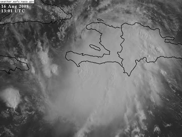
Yeah that was 4 hours ago, looks like its now S of Hispaniola looking at this visible.
But looks can be deceiving.
LINK
0 likes
-
Weatherfreak14

- Category 5
- Posts: 1381
- Joined: Sat Sep 24, 2005 3:40 pm
- Location: Beaufort, SC
- Contact:
Re:
Sabanic wrote:If the NHC track is going to verify Fay needs to start moving WNW soon. If not there may be a slight shift westward in the models later.
Its right on track, in a way it looks it may go north of the NHC forcast over the next, i seea very slight northward turn maybe by 1 or 2 degrees.
0 likes

Re:
Sabanic wrote:If the NHC track is going to verify Fay needs to start moving WNW soon. If not there may be a slight shift westward in the models later.
http://cimss.ssec.wisc.edu/tropic/real- ... lay48.html
yes, but not immedietely. on the latest update, TWC Lyons had it actually tracking a wee bit wws as it shoots the Jamaica/cuba gap them being recurved by the low in the gulf... still only predictions obviously. i''m inclined to stick with the NHC track for now and watch here more runs.
BTW, nice avatar, but sabin should not to be trusted!
0 likes

-
storms in NC

- S2K Supporter
- Posts: 2338
- Joined: Thu Jul 28, 2005 2:58 pm
- Location: Wallace,NC 40 miles NE of Wilm
- Contact:
Re: Re:
Weatherfreak14 wrote:Sabanic wrote:If the NHC track is going to verify Fay needs to start moving WNW soon. If not there may be a slight shift westward in the models later.
Its right on track, in a way it looks it may go north of the NHC forcast over the next, i seea very slight northward turn maybe by 1 or 2 degrees.
Yeah I seen that too but it also could be just building up to the north making look like it is moved north. But I still think a turn to the North will be vvery soon anyways. JMO
0 likes
-
Ed Mahmoud
Re: ATL: Tropical Storm Fay
I still think center could reform under deeper convection about a degree South of NHC position.
Decent concensus, especially if center doesn't reform under deeper convection, from 6Z models that this will bend WNW then NW soon, and pass near Keys and Miami.
Decent concensus, especially if center doesn't reform under deeper convection, from 6Z models that this will bend WNW then NW soon, and pass near Keys and Miami.
0 likes

Re:
Aquawind wrote:Fay is highly annoying now. She takes days to orgainize enough to be classified and then just before land it does. Now after going over a pretty mountainous island it was barely phased. Amazing Fay..
And if the current NHC track verifies,she could be able to get to major hurricane strength before reacjhing the Panhandle
0 likes
-
Shockwave
- Tropical Storm

- Posts: 167
- Joined: Fri Jul 25, 2008 7:33 am
- Location: Lafayette, TN
- Contact:
Re:
Aquawind wrote:Fay is highly annoying now. She takes days to orgainize enough to be classified and then just before land it does. Now after going over a pretty mountainous island it was barely phased. Amazing Fay..
And that is what has me most concerned. If the intercation with land didn't phase her much at all, then once she hits water (which she already has) I see a, possible, big intensification process for today.
0 likes
-
txwatcher91
- Category 5
- Posts: 1498
- Joined: Tue Aug 02, 2005 2:29 pm

-
TheShrimper
- Category 2

- Posts: 516
- Joined: Sun Aug 01, 2004 5:05 pm
Re: ATL: Tropical Storm Fay Pet and Wildlife Reactions
Very few signs of any birds around here today.......something may be up.
0 likes

Re: ATL: Tropical Storm Fay
not so sure Fay has made it away from the DR yet, even if she reaches water near that patch around port au prince she would be surrounded by mountains with limited inflow from the southeast and east especially, but also NE and SW (surrounded by land still) at least in my amateur opinion, it's not like she is emerging into a wide open ocean, but so long as she stays mostly west (say s of 19) she may dodge most of cuba, (may)
0 likes
-
Aquawind

- Category 5
- Posts: 6714
- Age: 62
- Joined: Mon Jun 16, 2003 10:41 pm
- Location: Salisbury, NC
- Contact:
Re: Re:
Shockwave wrote:Aquawind wrote:Fay is highly annoying now. She takes days to orgainize enough to be classified and then just before land it does. Now after going over a pretty mountainous island it was barely phased. Amazing Fay..
And that is what has me most concerned. If the intercation with land didn't phase her much at all, then once she hits water (which she already has) I see a, possible, big intensification process for today.
Looks like it will still go over Cuba's mountains but quickly and with nothing but hot water after.
0 likes
-
Emmett_Brown
- Category 5
- Posts: 1433
- Joined: Wed Aug 24, 2005 9:10 pm
- Location: Sarasota FL
Re: ATL: Tropical Storm Fay
Track is a big concern, but to me, with some part of FL squarely in the cone, i am more concerned about track relative to what it means for intensity. The model shift to the E would suggest less time over water, meaning weaker. We have to hope that Fay stays bogged down in land long enough to be another Ernesto, and not another Charley.
0 likes


Who is online
Users browsing this forum: No registered users and 59 guests