
Blown_away wrote:HURAKAN wrote:
You can see the LLC on your graphic. It's moving WNW just N of the second forecast point.
I agree shes going to cane status before she crosses any land over Cuba
Moderator: S2k Moderators


Derek Ortt wrote:Blown_away wrote:Watch the visible loop and turn on the tropical forecast points and the Lat/Long's. I think I see the LLC at 19.2N/74.9W, just north of the second forecast point. Looks like a little dark circle. Just an observation.
http://www.ssd.noaa.gov/goes/flt/t1/loop-vis.html
Cuban radar shows it WELL SOUTH of there
This is NOT going to make landfall along the EC of Florida.


Aquawind wrote:Shockwave wrote:If Fay misses Cuba all together and stays mostly on water, there's not a good path to go by. It would be bad all the way around.
I don't think ther is much chance at all it will miss Cuba. However if it goes far enough west it will have flatter terrain to cross and much less impact on the structure..not good. Then it will also have much more time over water pre and post Cuba.

Blown_away wrote:Watch the visible loop and turn on the tropical forecast points and the Lat/Long's. I think I see the LLC at 19.2N/74.9W, just north of the second forecast point. Looks like a little dark circle. Just an observation.
http://www.ssd.noaa.gov/goes/flt/t1/loop-vis.html

Weatherfreak14 wrote:Derek Ortt wrote:This is NOT going to make landfall along the EC of Florida.
Well derek you also said that this wouldnt not develop and "next please" a couple of days ago
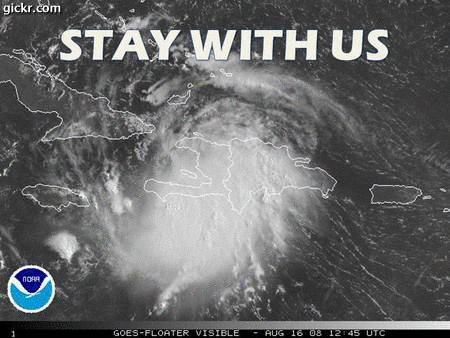
Blown_away wrote:[img][/img]
If that is not the LLC, show me where it is.
Blown_away wrote: If that is not the LLC, show me where it is.
cpdaman wrote:Blown_away wrote:[img]
If that is not the LLC, show me where it is.
btw that's 73.9 not 74.9 like in your post


Blown_away wrote:cpdaman wrote:Blown_away wrote:[img]
If that is not the LLC, show me where it is.
btw that's 73.9 not 74.9 like in your post
Sorry, sorry, I meant 73.9.
HURAKAN wrote:Excellent Loop: http://hadar.cira.colostate.edu/ramsdis ... ive_0.html

Extremeweatherguy wrote:If the radar already shows this west of Haiti, then this system seems to be moving slightly faster than the 5am track had predicted. Fay may wind up reaching its 2AM Sunday forecast point by as early as this afternoon or evening...
radar loop: http://www.insmet.cu/Radar/06Gran%20Pie ... AXw01a.gif

Users browsing this forum: No registered users and 22 guests

