ATL: Tropical Depression Fay
Moderator: S2k Moderators
-
Bocadude85

- Category 5

- Posts: 2991
- Age: 39
- Joined: Mon Apr 18, 2005 2:20 pm
- Location: Honolulu,Hi
Re: ATL: Tropical Storm Fay
wonder what the chances of this falling apart and not really amounting to much of anything?
0 likes
-
Stephanie

- S2K Supporter

- Posts: 23843
- Age: 63
- Joined: Thu Feb 06, 2003 9:53 am
- Location: Glassboro, NJ
Re: ATL: Tropical Storm Fay
We've seen storms ripped apart only to come together again, though maybe not as strong.
That latest image has all of the convection to the east and southeast. The last satelite loop did look like a WNW direction of movement.
That latest image has all of the convection to the east and southeast. The last satelite loop did look like a WNW direction of movement.
0 likes
-
Dean4Storms
- S2K Supporter
- Posts: 6358
- Age: 63
- Joined: Sun Aug 31, 2003 1:01 pm
- Location: Miramar Bch. FL
-
Stephanie
- S2K Supporter
- Posts: 23843
- Age: 63
- Joined: Thu Feb 06, 2003 9:53 am
- Location: Glassboro, NJ
Re: Re:
vbhoutex wrote:Blown_away wrote:Dean4Storms wrote:Does anyone else see the LLC near 19.5 74.5?
It shows up well on the Ramsdis floater........
http://www.cira.colostate.edu/cira/RAMM ... pical.html
Yep, pretty clear to me moving WNW, exposed center.
http://www.ssd.noaa.gov/goes/flt/t1/loop-vis.html
Based on that loop I see 19.4N, 79.8W or very close to that. Once the consolidation begins I wouldn't be surprised if it actually "moves" a little SW of where it appears now. Honestly after three different visibles it is not easy to pinpoint it. When the plane gets in we will know more(DUH!!!
It's hard to see in the visibles. The loops have shown two different circulations though in an North/South alignment.
0 likes
-
cycloneye

- Admin

- Posts: 149379
- Age: 69
- Joined: Thu Oct 10, 2002 10:54 am
- Location: San Juan, Puerto Rico
Re: ATL: Tropical Storm Fay
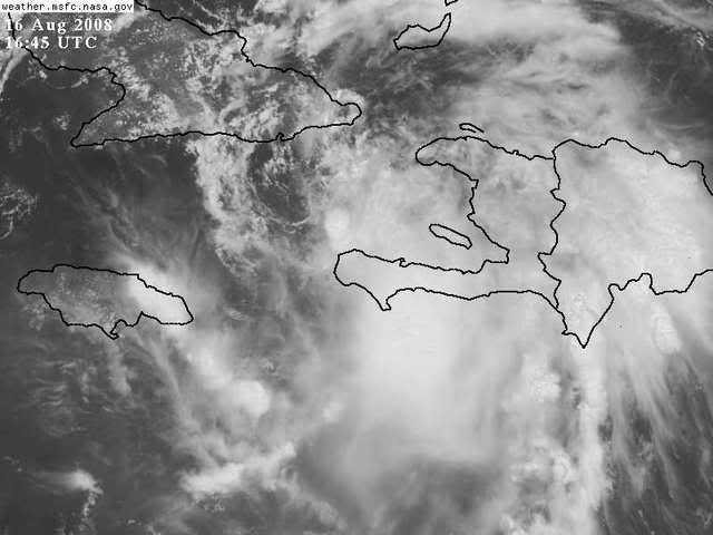
Here is a closeup view.As HURAKAN points up,the center is where you see that little white blob,just north of the Penninsula of Haiti.

0 likes

Re: ATL: Tropical Storm Fay
Latest Rainbow loop shows feeders developing for the MLC .
http://www.ssd.noaa.gov/goes/flt/t1/loop-rb.html
http://www.ssd.noaa.gov/goes/flt/t1/loop-rb.html
0 likes
-
Dean4Storms
- S2K Supporter
- Posts: 6358
- Age: 63
- Joined: Sun Aug 31, 2003 1:01 pm
- Location: Miramar Bch. FL
Re:
HURAKAN wrote:
The center is exactly under that burst of convection north of the tip of that peninsula in Haiti.
The LLC is NW of that, you can clearly see the wrapping in of low level clouds and the convection to its west is spiraling inward toward it. It is near 19.5 74.7
Watch the floater here...... (It is so plain my half blind grandma can see.
http://moe.met.fsu.edu/cgi-bin/gfdltc2. ... =Animation
Last edited by Dean4Storms on Sat Aug 16, 2008 12:06 pm, edited 1 time in total.
0 likes
-
HURAKAN

- Professional-Met

- Posts: 46084
- Age: 39
- Joined: Thu May 20, 2004 4:34 pm
- Location: Key West, FL
- Contact:
http://wwwghcc.msfc.nasa.gov/GOES/goeseastconus.html
Using the GOES East 1 km Visible Weather Satellite Picture is really easy to see the circulation. I don't know why there is a debate about it.
Using the GOES East 1 km Visible Weather Satellite Picture is really easy to see the circulation. I don't know why there is a debate about it.
0 likes


-
Extremeweatherguy

- Category 5
- Posts: 11095
- Joined: Mon Oct 10, 2005 8:13 pm
- Location: Florida
It is hard to tell where the exact center is, but looking at several satellite loops, it seems like the current motion would take the storm along the extreme southeastern coast of Cuba...probably staying far enough offshore to still be able to get its act together later today:
http://www.cira.colostate.edu/cira/RAMM ... pical.html
NHC track still looks pretty good, IMO.
http://www.cira.colostate.edu/cira/RAMM ... pical.html
NHC track still looks pretty good, IMO.
0 likes
-
Blown Away

- S2K Supporter
- Posts: 10253
- Joined: Wed May 26, 2004 6:17 am
Re: ATL: Tropical Storm Fay
I like Accuweather and Joe B, there informative and entertaining, but their tropics page has 2 maps with the first moving Fay up the W side of FL into the Panhandle and the other pointing up the E coast of FL. Weather info should not be that confusing, IMO.
http://www.accuweather.com/news-top-hea ... 8-16_08:41
http://www.accuweather.com/news-top-hea ... 8-16_08:41
0 likes
-
Dean4Storms
- S2K Supporter
- Posts: 6358
- Age: 63
- Joined: Sun Aug 31, 2003 1:01 pm
- Location: Miramar Bch. FL
Re:
Noles2006 wrote:Dean - before you make that your final answer... read what Derek said on page 257 regarding it possibly being a transient feature...
I saw what Derek said. But it is a clear LLC and I know a LLC on Sat imagery when I see one. It is very simple to see the Low level flow going into it and the banding just to its west fedding into it as I type.
0 likes
-
Dean4Storms
- S2K Supporter
- Posts: 6358
- Age: 63
- Joined: Sun Aug 31, 2003 1:01 pm
- Location: Miramar Bch. FL
That ball of convection. If you look you'll see a SW to NE line of thin convection moving swing East but individually moving NE to wrap around the center to the NW of that ball someone pointed out. Any convection to the west of a LLC would be swinging in a band to the South.
She does appear to be moving almost due west.
She does appear to be moving almost due west.
Last edited by Dean4Storms on Sat Aug 16, 2008 12:14 pm, edited 1 time in total.
0 likes
-
wxman57

- Moderator-Pro Met

- Posts: 23172
- Age: 68
- Joined: Sat Jun 21, 2003 8:06 pm
- Location: Houston, TX (southwest)
Re: ATL: Tropical Storm Fay
Sure looks like the center is exposed to me, near 19.4N/75.1W. Observations along the southern coast of Cuba seem to confirm the LLC there. Clear rotation on satellite. If this is the case, then we likely have TD Fay now, unless there's a small pocket of TS force winds in that squalls south of the Haitian peninsula.
Last edited by wxman57 on Sat Aug 16, 2008 12:14 pm, edited 1 time in total.
0 likes

-
jlauderdal
- S2K Supporter
- Posts: 7240
- Joined: Wed May 19, 2004 5:46 am
- Location: NE Fort Lauderdale
- Contact:
Re: ATL: Tropical Storm Fay
Blown_away wrote:I like Accuweather and Joe B, there informative and entertaining, but their tropics page has 2 maps with the first moving Fay up the W side of FL into the Panhandle and the other pointing up the E coast of FL. Weather info should not be that confusing, IMO.
http://www.accuweather.com/news-top-hea ... 8-16_08:41
its called ensuring you will be right...

0 likes
-
Aric Dunn
- Category 5
- Posts: 21238
- Age: 43
- Joined: Sun Sep 19, 2004 9:58 pm
- Location: Ready for the Chase.
- Contact:
Re: ATL: Tropical Storm Fay
wxman57 wrote:Sure looks like the center is exposed to me, near 19.5N/75W. Observations along the southern coast of Cuba seem to confirm the LLC there. If this is the case, then we likely have TD Fay now, unless there's a small pocket of TS force winds in that squalls south of the Haitian peninsula.
thats nearly exactly what i was about to post

0 likes
Re: Re:
Dean4Storms wrote:HURAKAN wrote:
The center is exactly under that burst of convection north of the tip of that peninsula in Haiti.
The LLC is NW of that, you can clearly see the wrapping in of low level clouds and the convection to its west is spiraling inward toward it. It is near 19.5 74.7
Watch the floater here...... (It is so plain my half blind grandma can see.
http://moe.met.fsu.edu/cgi-bin/gfdltc2. ... =Animation
Check your URL
0 likes
-
Dean4Storms
- S2K Supporter
- Posts: 6358
- Age: 63
- Joined: Sun Aug 31, 2003 1:01 pm
- Location: Miramar Bch. FL
Re: ATL: Tropical Storm Fay
wxman57 wrote:Sure looks like the center is exposed to me, near 19.4N/75.1W. Observations along the southern coast of Cuba seem to confirm the LLC there. Clear rotation on satellite. If this is the case, then we likely have TD Fay now, unless there's a small pocket of TS force winds in that squalls south of the Haitian peninsula.
Thank you for the clarity wxman57.
0 likes
Who is online
Users browsing this forum: No registered users and 43 guests