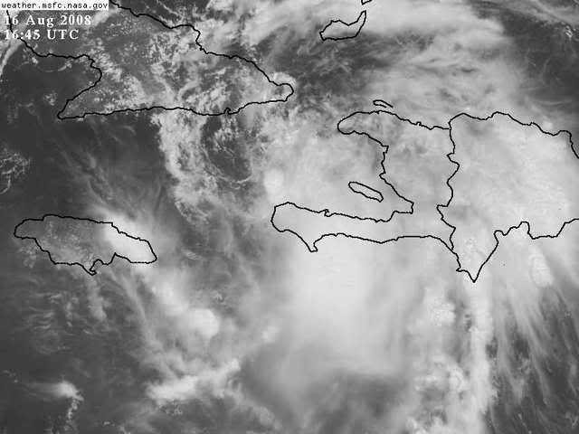
19.4/75.0 is what I got...
moving nearly due west...
ATL: Tropical Depression Fay
Moderator: S2k Moderators
-
Noles2006

- Category 1

- Posts: 424
- Joined: Thu Jun 08, 2006 9:57 am
- Location: Tallahassee, Florida
- Contact:
Re: ATL: Tropical Storm Fay
0 likes
-
vbhoutex

- Storm2k Executive

- Posts: 29147
- Age: 74
- Joined: Wed Oct 09, 2002 11:31 pm
- Location: Cypress, TX
- Contact:
Re: ATL: Tropical Storm Fay
That is 3(make that 4) for the almost exact same exposed location. It sure seems pretty obvious to me. I guess that is why I posted it without the loop link.
Anyone that is thinking otherwise please post your reasoning and any supportive data you may have. I am always open to new information!!!
Anyone that is thinking otherwise please post your reasoning and any supportive data you may have. I am always open to new information!!!
0 likes
-
Dean4Storms
- S2K Supporter

- Posts: 6358
- Age: 63
- Joined: Sun Aug 31, 2003 1:01 pm
- Location: Miramar Bch. FL
Re: ATL: Tropical Storm Fay
Aric Dunn wrote:wxman57 wrote:Sure looks like the center is exposed to me, near 19.5N/75W. Observations along the southern coast of Cuba seem to confirm the LLC there. If this is the case, then we likely have TD Fay now, unless there's a small pocket of TS force winds in that squalls south of the Haitian peninsula.
thats nearly exactly what i was about to post

Pretty close Aric just maybe a bit further west, you see that cloud band SW to NE just to the west of that circle? That is a feeder band going into it to the WNW of your circle.
Last edited by Dean4Storms on Sat Aug 16, 2008 12:19 pm, edited 1 time in total.
0 likes
-
hurricanefloyd5
- Category 5

- Posts: 1659
- Age: 45
- Joined: Sun May 02, 2004 10:53 am
- Location: Spartanburg
- Contact:
Re: ATL: Tropical Storm Fay
FAY COULD STRENGTHEN RAPIDLY IF IT BECOMES WELL
ORGANIZED OVER WATER. ON THE OTHER HAND IT MIGHT NOT STRENGTHEN
MUCH AT ALL IF LAND INTERACTION PREVENTS ORGANIZATION.
This is what's in the 11am. discuss. towards the end and if this happen this COULD be a hugh problem for FLORIDA!!!!!!!!!!
ORGANIZED OVER WATER. ON THE OTHER HAND IT MIGHT NOT STRENGTHEN
MUCH AT ALL IF LAND INTERACTION PREVENTS ORGANIZATION.
This is what's in the 11am. discuss. towards the end and if this happen this COULD be a hugh problem for FLORIDA!!!!!!!!!!
0 likes
-
cycloneye

- Admin
- Posts: 149379
- Age: 69
- Joined: Thu Oct 10, 2002 10:54 am
- Location: San Juan, Puerto Rico
Re: ATL: Tropical Storm Fay
The debate about where the center is will be over in less than a half an hour when recon arrives.
0 likes


It does not look too healthy atm. Keeping the eyes peeled, though.
http://www.atmos.washington.edu/~ovens/ ... t_enhanced
http://www.atmos.washington.edu/~ovens/ ... t_enhanced
0 likes
-
Derek Ortt

-
Aric Dunn
- Category 5
- Posts: 21238
- Age: 43
- Joined: Sun Sep 19, 2004 9:58 pm
- Location: Ready for the Chase.
- Contact:
Re: ATL: Tropical Storm Fay
Dean4Storms wrote:Aric Dunn wrote:wxman57 wrote:Sure looks like the center is exposed to me, near 19.5N/75W. Observations along the southern coast of Cuba seem to confirm the LLC there. If this is the case, then we likely have TD Fay now, unless there's a small pocket of TS force winds in that squalls south of the Haitian peninsula.
thats nearly exactly what i was about to post
Pretty close Aric just maybe a bit further west, you see that cloud band SW to NE just to the west of that circle? That is a feeder band going into it to the WNW of your circle.

posted the wrong update
Last edited by Aric Dunn on Sat Aug 16, 2008 12:23 pm, edited 1 time in total.
0 likes
-
Dean4Storms
- S2K Supporter
- Posts: 6358
- Age: 63
- Joined: Sun Aug 31, 2003 1:01 pm
- Location: Miramar Bch. FL
Re: Re:
tailgater wrote:Dean4Storms wrote:HURAKAN wrote:
The center is exactly under that burst of convection north of the tip of that peninsula in Haiti.
The LLC is NW of that, you can clearly see the wrapping in of low level clouds and the convection to its west is spiraling inward toward it. It is near 19.5 74.7
Watch the floater here...... (It is so plain my half blind grandma can see.
http://moe.met.fsu.edu/cgi-bin/gfdltc2. ... =Animation
Check your URL
ooppss, Sorry, here ya go......
http://www.cira.colostate.edu/cira/RAMM ... pical.html
0 likes
-
JonathanBelles
- Professional-Met

- Posts: 11430
- Age: 35
- Joined: Sat Dec 24, 2005 9:00 pm
- Location: School: Florida State University (Tallahassee, FL) Home: St. Petersburg, Florida
- Contact:


Re: ATL: Tropical Storm Fay
vbhoutex wrote:That is 3(make that 4) for the almost exact same exposed location. It sure seems pretty obvious to me. I guess that is why I posted it without the loop link.
Anyone that is thinking otherwise please post your reasoning and any supportive data you may have. I am always open to new information!!!
I can't see how anyone can produce any supportive data that can argue that the center is not exposed. It's definitely exposed.
0 likes

Re: ATL: Tropical Storm Fay
vbhoutex wrote:That is 3(make that 4) for the almost exact same exposed location. It sure seems pretty obvious to me. I guess that is why I posted it without the loop link.
Anyone that is thinking otherwise please post your reasoning and any supportive data you may have. I am always open to new information!!!
I'm not saying it's not the LLC but it's possible that it's only a vortex rotating around a broader center I'll have to see more of a loop to be sure.
0 likes
-
wxman57

- Moderator-Pro Met

- Posts: 23172
- Age: 68
- Joined: Sat Jun 21, 2003 8:06 pm
- Location: Houston, TX (southwest)
Re: ATL: Tropical Storm Fay
If Fay has weakened to a TD this afternoon, even if still may have a few pockets of TS winds well SE of the center, then the chances of it becoming a hurricane before reaching Cuba are very low. And the chances of its circulation falling apart over Cuba are increasing. The threat to Florida may be decreasing significantly.
0 likes
-
Dean4Storms
- S2K Supporter
- Posts: 6358
- Age: 63
- Joined: Sun Aug 31, 2003 1:01 pm
- Location: Miramar Bch. FL
Re: ATL: Tropical Storm Fay
Pretty close Aric just maybe a bit further west, you see that cloud band SW to NE just to the west of that circle? That is a feeder band going into it to the WNW of your circle.[/quote]
 [/quote]
Close, take that blue circle north a tad and you are on it.
[/quote]Close, take that blue circle north a tad and you are on it.
0 likes
-
jaxfladude
- Category 5
- Posts: 1249
- Joined: Wed Aug 24, 2005 9:36 pm
- Location: Jacksonville, Fla
Re:
fact789 wrote:Governor Charlie Crist is doing a live press conference now!!
Well that almost dooms

0 likes
-
JonathanBelles
- Professional-Met
- Posts: 11430
- Age: 35
- Joined: Sat Dec 24, 2005 9:00 pm
- Location: School: Florida State University (Tallahassee, FL) Home: St. Petersburg, Florida
- Contact:
-
Derek Ortt
-
wxman57
- Moderator-Pro Met
- Posts: 23172
- Age: 68
- Joined: Sat Jun 21, 2003 8:06 pm
- Location: Houston, TX (southwest)
Re: ATL: Tropical Storm Fay
tailgater wrote:vbhoutex wrote:That is 3(make that 4) for the almost exact same exposed location. It sure seems pretty obvious to me. I guess that is why I posted it without the loop link.
Anyone that is thinking otherwise please post your reasoning and any supportive data you may have. I am always open to new information!!!
I'm not saying it's not the LLC but it's possible that it's only a vortex rotating around a broader center I'll have to see more of a loop to be sure.
You're correct, tailgater. Sometimes weak tropical storms with broad centers can have multiple vortices rotating around. I can't see any evidence of another center to the southeast, though. Even if there was another center, the fact that it has multiple vortices rotating around (and I only see one center) would indicate a weaker storm.
0 likes
-
mavidal@mac.com
- Tropical Wave

- Posts: 1
- Joined: Wed Jul 16, 2008 11:51 am
Re: ATL: Tropical Storm Fay Pet and Wildlife Reactions
Howdy all:
New to this board, but not storms. I am in Miami, have been here since 59 so I have been through a few storms (especially the eyewall adventure with Andrew), and have not seen any songbirds (my barometer) since yesterday am. Still quiet this morning. This has been a consistent pattern that I have noticed with every approaching hurricane, not tropical storms. My gut is telling me that Fay is headed this way and will be a hurricane when it gets here.
BTW, what I have never figured out is why doves and pigeons don't leave?
MV
0 likes


Re: TS Fay Personal forecasts
The posts in this forum are NOT official forecasts and should not be used as such. They are just the opinion of the poster and may or may not be backed by sound meteorological data. They are NOT endorsed by any professional institution or storm2k.org. For official information, please refer to the NHC and NWS products.
I like what I see this afternoon, although preparedness is still important for everyone within the forecast cone (as always).
As many have noted today, the LLC and MLC of Fay appear to have temporarily decoupled due to the passage of the system over the extremely mountainous terrain of Hispaniola. I would be surprised to see any significant intensification today, and I expect that it will take at least 18 hours for Fay to begin to stack again, now that it is moving over water. Note, however, that the Tiburon Peninsula of Haiti, home to mountains well over 8,000 feet, will severely impede the southern inflow of this system, further slowing the intensification process.
Once the system begins to clear Haiti and approach Cuba, I believe a small window for modest intensification will exist. However, I do not see Fay becoming a hurricane as it approaches Cuba. The system has been too disrupted and will still be subject to land interaction, particularly as it approaches more mountainous terrain in the southeastern tip of Cuba (6,000+ feet). IMHO, no more than 50 knots at landfall in Central Cuba (still a major disruption, however). There, a few mountain peaks of 3500+ feet exist -- enough to cause some weakening and disruption, although transit time over this area is expected to be brief.
If Fay does indeed follow the forecast track, it then has, at best, 24 good hours over the warm waters of the Florida Straits after emerging Central Cuba. I do not see this being enough time for strengthening to hurricane status, although it cannot be ruled out. I am going to stick adamantly to my expectation yesterday that this storm will be no more than 45-60 knots for SW Florida.
Admittably, if Fay gets out over the warm Gulf waters and heads farther north than, say, Fort Myers, all bets are off.
0 likes
Who is online
Users browsing this forum: No registered users and 22 guests