ATL: Tropical Depression Fay

Moderator: S2k Moderators

Message
Author
dolebot_Broward_NW
Category 2
Category 2
Posts: 529
Joined: Fri Sep 10, 2004 6:38 am

#5321 Postby dolebot_Broward_NW » Sat Aug 16, 2008 1:04 pm

If it misses Florida (and Bahamas and Bermuda), that would be the best news..


I would LOVE to see her track right along the east edge of the gulf stream and out to sea...

If there is anything important you guys hear would you let us know?


Does channel 7 ever say anything important? Like now a full 72-96 hours before anything - hourly storm coverage. Way to whip us into a frenzy!
0 likes   

GreenSky
Tropical Storm
Tropical Storm
Posts: 109
Joined: Mon Aug 11, 2008 8:34 pm
Location: Land of Alex Jones!-Austin,TX

Re: ATL: Tropical Storm Fay

#5322 Postby GreenSky » Sat Aug 16, 2008 1:04 pm

wxman57 wrote:Here's a satellite with surface obs plotted. As you can see, not exactly a ferocious wind field around the center. Just 15-20 kts.

Image


Wxman, don't you think Fay will be downgraded to a depression or maybe an open wave....it looks like the LLC has vanished!

Maybe the DR really did kill Fay.
0 likes   

User avatar
deltadog03
Professional-Met
Professional-Met
Posts: 3580
Joined: Tue Jul 05, 2005 6:16 pm
Location: Macon, GA

#5323 Postby deltadog03 » Sat Aug 16, 2008 1:06 pm

Thanks WXMAN...Well, that IS where the 2pm adv.. position is...So, nhc must be thinking the same. Either way, I posted the steering map for the associated strength of fay, this too me still says she should stay generally around 275 degrees for the movement. There is a weakness over the florida straits, but this is not strong enough to feel that right now.
0 likes   

User avatar
TampaFl
S2K Supporter
S2K Supporter
Posts: 1905
Age: 68
Joined: Thu Sep 04, 2003 11:23 am
Location: Tampa, FL

Re: ATL: Tropical Storm Fay

#5324 Postby TampaFl » Sat Aug 16, 2008 1:07 pm

Map curtesy of Boatusa.com:

Image
0 likes   

User avatar
Extremeweatherguy
Category 5
Category 5
Posts: 11095
Joined: Mon Oct 10, 2005 8:13 pm
Location: Florida

#5325 Postby Extremeweatherguy » Sat Aug 16, 2008 1:11 pm

New convection appears to be popping on the SE side of the LLC...

Image
0 likes   

shortwave
S2K Supporter
S2K Supporter
Posts: 156
Age: 53
Joined: Mon May 24, 2004 5:56 pm
Location: palm bay, fl.

#5326 Postby shortwave » Sat Aug 16, 2008 1:12 pm

Fay is a clam, opens in water, closes over land. Maybe because there hasn't consistently been a narrow focus of surface convergence, save for the mid levels.

As always things are changing with this and every system.
0 likes   

User avatar
HURAKAN
Professional-Met
Professional-Met
Posts: 46086
Age: 38
Joined: Thu May 20, 2004 4:34 pm
Location: Key West, FL
Contact:

#5327 Postby HURAKAN » Sat Aug 16, 2008 1:13 pm

Image
0 likes   

cpdaman
Category 5
Category 5
Posts: 3131
Joined: Sat Jun 10, 2006 11:44 am
Location: SPB county (gulf stream)

Re: ATL: Tropical Storm Fay

#5328 Postby cpdaman » Sat Aug 16, 2008 1:14 pm

also appears to be an eddy just NW of NW tip of haiti
0 likes   

CrazyC83
Professional-Met
Professional-Met
Posts: 34303
Joined: Tue Mar 07, 2006 11:57 pm
Location: Deep South, for the first time!

#5329 Postby CrazyC83 » Sat Aug 16, 2008 1:14 pm

It's not a depression as the flight supports 35 kt. It is either a tropical storm or (less likely) an open wave.
0 likes   

User avatar
Blown Away
S2K Supporter
S2K Supporter
Posts: 10252
Joined: Wed May 26, 2004 6:17 am

Re: ATL: Tropical Storm Fay

#5330 Postby Blown Away » Sat Aug 16, 2008 1:16 pm

wxman57 wrote:New GFDL takes the center just east of Miami now. Trend east continues.

I always had my doubts that the LLC could survive a trip over Hispanola and E Cuba, but if it emerges and moves up on the NE side of Cuba and there is plenty alot of warm waters to spin up pretty quick. This was the only scenerio I was worried about.
0 likes   

User avatar
wxman57
Moderator-Pro Met
Moderator-Pro Met
Posts: 23080
Age: 68
Joined: Sat Jun 21, 2003 8:06 pm
Location: Houston, TX (southwest)

Re: ATL: Tropical Storm Fay

#5331 Postby wxman57 » Sat Aug 16, 2008 1:17 pm

TampaFl wrote:Map curtesy of Boatusa.com:

http://www.boatus.com/hurricanes/upload/6/windfield.gif


Take a look at the actual surface plot I posted and you'll see those forecast winds are about 20-25 kts too high.
0 likes   

User avatar
Noles2006
Category 1
Category 1
Posts: 424
Joined: Thu Jun 08, 2006 9:57 am
Location: Tallahassee, Florida
Contact:

Re: ATL: Tropical Storm Fay

#5332 Postby Noles2006 » Sat Aug 16, 2008 1:18 pm

Blown_away wrote:
wxman57 wrote:New GFDL takes the center just east of Miami now. Trend east continues.

I always had my doubts that the LLC could survive a trip over Hispanola and E Cuba, but if it emerges and moves up on the NE side of Cuba and there is plenty alot of warm waters to spin up pretty quick. This was the only scenerio I was worried about.


Fay would have to start the turn almost immediately to move over NE Cuba...
0 likes   

Derek Ortt

#5333 Postby Derek Ortt » Sat Aug 16, 2008 1:18 pm

yet HWRF shifted west of the previous run
0 likes   

User avatar
wxman57
Moderator-Pro Met
Moderator-Pro Met
Posts: 23080
Age: 68
Joined: Sat Jun 21, 2003 8:06 pm
Location: Houston, TX (southwest)

Re:

#5334 Postby wxman57 » Sat Aug 16, 2008 1:19 pm

CrazyC83 wrote:It's not a depression as the flight supports 35 kt. It is either a tropical storm or (less likely) an open wave.


Hang on there, the plane was finding 40-50 kt winds at flight level the other day but couldn't find an LLC. Don't assume those FL winds are translating to the surface.
0 likes   

cpdaman
Category 5
Category 5
Posts: 3131
Joined: Sat Jun 10, 2006 11:44 am
Location: SPB county (gulf stream)

Re: ATL: Tropical Storm Fay

#5335 Postby cpdaman » Sat Aug 16, 2008 1:19 pm

that depends on wether recon verify's the 19.2 74.8 position ...i think it may be further east
0 likes   

User avatar
wxman57
Moderator-Pro Met
Moderator-Pro Met
Posts: 23080
Age: 68
Joined: Sat Jun 21, 2003 8:06 pm
Location: Houston, TX (southwest)

Re:

#5336 Postby wxman57 » Sat Aug 16, 2008 1:19 pm

Derek Ortt wrote:yet HWRF shifted west of the previous run


I think Naomi needs to do more tweaking to HWRF.
0 likes   

CrazyC83
Professional-Met
Professional-Met
Posts: 34303
Joined: Tue Mar 07, 2006 11:57 pm
Location: Deep South, for the first time!

Re: Re:

#5337 Postby CrazyC83 » Sat Aug 16, 2008 1:20 pm

wxman57 wrote:
CrazyC83 wrote:It's not a depression as the flight supports 35 kt. It is either a tropical storm or (less likely) an open wave.


Hang on there, the plane was finding 40-50 kt winds at flight level the other day but couldn't find an LLC. Don't assume those FL winds are translating to the surface.


That is because the system was a 40-45 kt tropical wave then.
0 likes   

Derek Ortt

#5338 Postby Derek Ortt » Sat Aug 16, 2008 1:21 pm

and the GFDL assumes we already have a hurricane

not buying that east shift
0 likes   

User avatar
Extremeweatherguy
Category 5
Category 5
Posts: 11095
Joined: Mon Oct 10, 2005 8:13 pm
Location: Florida

Re: ATL: Tropical Storm Fay

#5339 Postby Extremeweatherguy » Sat Aug 16, 2008 1:21 pm

cpdaman wrote:that depends on wether recon verify's the 19.2 74.8 position ...i think it may be further east
You may be right. According to the recon thread, there was a pressure of 1006mb found at 19.2N 72.6W.
0 likes   

User avatar
Emmett_Brown
Category 5
Category 5
Posts: 1433
Joined: Wed Aug 24, 2005 9:10 pm
Location: Sarasota FL

Re: ATL: Tropical Storm Fay

#5340 Postby Emmett_Brown » Sat Aug 16, 2008 1:21 pm

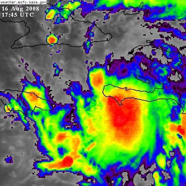
Regarding sattelite appearence, here is what i am seeing:

- Land clearly did a number on Fay
- However, banding features that have been absent are beginning to appear in the Bahamas, and to the SW in the Carribean near Jamaica.
- Some bursting is ocurring near the difuse center
- Outflow is still excellent in all directions
- Fay is heading just N of due W, which may keep her S of Cuba for a bit tonight and over hot water
- Dry air is not a problem

Overall, more pros than cons for strengthening. There is still a lot of time. Even if she is steady state and does not strengthen this afternoon, and starts to strengthen tonight, there is all day tomorrow for her to strengthen. Assuming she stays on track over water, it is not unreasonable for Fay to reach miminum Cat 1 hurricane strength by the end of the day tomorrow before landfalling in Cuba.

In short, i dont expect Fay to strengthen until tonight. Too many mountains around. But I dont think she will fall apart either.
0 likes   


Return to “2008”

Who is online

Users browsing this forum: No registered users and 63 guests