ATL: Tropical Depression Fay

Moderator: S2k Moderators

Message
Author
User avatar
AdamFirst
S2K Supporter
S2K Supporter
Posts: 2490
Age: 36
Joined: Thu Aug 14, 2008 10:54 am
Location: Port Saint Lucie, FL

Re: Re:

#5601 Postby AdamFirst » Sat Aug 16, 2008 4:30 pm

lbvbl wrote:
gatorcane wrote::uarrow:

and another thing to note, if Fay deepens more quickly as it appears it may be trying to do expect some more right shifts in the models as fay attempts to move poleward and "finds" the weakness more easily.

looks like the GFDL and some of the other models that had Fay deepening fairly quickly may just be right...we'll have to see.


What do u mean by deepening? Sorry, I am very much an amateur when it comes to this stuff.


Deepening means strengthening.
0 likes   

User avatar
KWT
Category 5
Category 5
Posts: 31416
Joined: Tue Aug 17, 2004 11:02 am
Location: UK!!!

#5602 Postby KWT » Sat Aug 16, 2008 4:30 pm

The idea that if it gets stronger it will go further north is probably pretty vaild though should be noted that the GFDL is already a little far north of where this is.

Honestly the NHC looks decent enough, Fay is looking steadily better, its one of those systems that could undergo RI given its apperence isn't stunning still IMO yet still recon finds winds of 45-50kts. Still totally lop sided as well but thats what you'd expect with Cuba very close by.
Last edited by KWT on Sat Aug 16, 2008 4:32 pm, edited 1 time in total.
0 likes   

User avatar
ronjon
Category 5
Category 5
Posts: 4886
Joined: Fri Aug 19, 2005 5:17 pm
Location: Hernando Beach, FL

Re: ATL: Tropical Storm Fay

#5603 Postby ronjon » Sat Aug 16, 2008 4:31 pm

Well, if the intensity forecast is correct - and that is a big IF, then a CAT 1 hurricane won't be too bad for most of us since once inland it should weaken to a tropical storm fairly quickly. My only nagging worry is RI in the SE GOM - looks like it'll have 24 hrs after leaving the Cuba coast to intensify prior to the FL west coast landfall. If memory serves me, Charley really exploded in the SE GOM (I think it went from CAT 2 to CAT 4).
0 likes   

User avatar
gatorcane
S2K Supporter
S2K Supporter
Posts: 23703
Age: 47
Joined: Sun Mar 13, 2005 3:54 pm
Location: Boca Raton, FL

Re: Re:

#5604 Postby gatorcane » Sat Aug 16, 2008 4:31 pm

tampastorm wrote:
johngaltfla wrote:
KWT wrote:Should be noted here that this track is close to Charley and we all remember the way Charley altered its attack approach by only a small amount but it made a huge world of difference to the landfall zone, should the same happen here then somewhere could get a surprise.


I happen to agree. There are a lot of folks that live on the West Coast of Florida who remember how "lucky" they were and this means that everyone from Marco Island up to the Big Bend need to watch for a last minute turn. My larger concern is sudden intensification.


But remember after landfall Charley went to the east coast of FL, in this senario no matter where landfall is Tampa area should be affected in some way.


Not so sure about that. If Fay manages to take a track far enough away SE of Tampa, The Tampa area would be on the "better" side (NW quadrant) of the system. Usually the dirty side or NE quadrant is the worse side.

But since Tampa's in the cone residents should take measures to prepare for the worst, even if it never comes to fruition.
0 likes   

User avatar
storms in NC
S2K Supporter
S2K Supporter
Posts: 2338
Joined: Thu Jul 28, 2005 2:58 pm
Location: Wallace,NC 40 miles NE of Wilm
Contact:

Re: ATL: Tropical Storm Fay

#5605 Postby storms in NC » Sat Aug 16, 2008 4:34 pm

ronjon wrote:To all you posters jumping on the GFDL and Euro, looks like the NHC didn't put much stock in those runs today. Perhaps we'll know why in the 5 PM discussion.


Personal Forecast Disclaimer:
The posts in this forum are NOT official forecast and should not be used as such. They are just the opinion of the poster and may or may not be backed by sound meteorological data. They are NOT endorsed by any professional institution or storm2k.org. For official information, please refer to the NHC and NWS products.[/quote]


Well The GFDL has always done a very very good job. I really don't know why I wouldn't trust it now. I have said all along it would be more east of Fl and not the west side. And I Don't think she will go between Jamaica and Cuba either. I know I am not a met and don't clam to be one either. But you have the troff going off the coast now and Fay is feeling it. You can see it trying to pull her up to the North. You should see the turn in a few hours and go across Cuba tonight. She will be on a more of a NW track.

And I know you all see that I live in NC. I have never said it was going to come up this way. NEVER. 1 reason is cause I don't think she will make it up this far before she turns out to sea. Oh we could use the rain badly. I didn't know how bad till I did something dumb earlier. I took the water hoes and was running the ants out so I could kill them and my hose keep coming in farther and father then the water stop coming to the top and I couldn't get the hoes out. Had to get post digger and had to dig down 6 foot be for I could get my hoes out. I should have ran into water about 4 feet No water at all. that is how dry it is here. Shame we can't get the rain from Fay. Would be nice.
But any ways I trust The GFDL. I might eat crow NC BBQ style


Deb
0 likes   

User avatar
KWT
Category 5
Category 5
Posts: 31416
Joined: Tue Aug 17, 2004 11:02 am
Location: UK!!!

#5606 Postby KWT » Sat Aug 16, 2008 4:35 pm

Thats the issue Ronjon, if it does have a good set-up it could strengthen pretty rapidly, we've seen systems become monsters in 24hrs in high heat content, low shear set-ups. Though I think much depends on whether it can get better organised before Cuban landfall, IMO its getting slowly better and LLC is strong but convection still looks pretty poor, though bet it looks far better in 12hrs time...these systems usually take a good 12hrs after large land interaction such as DR to totally recover.

The simple truth is thus far ECM/GFDL has always been on the eastern side of what has actually occured, no reason why the same shouldn't happen again.
0 likes   

User avatar
Noles2006
Category 1
Category 1
Posts: 424
Joined: Thu Jun 08, 2006 9:57 am
Location: Tallahassee, Florida
Contact:

Re: ATL: Tropical Storm Fay

#5607 Postby Noles2006 » Sat Aug 16, 2008 4:39 pm

storms in NC wrote:
ronjon wrote:To all you posters jumping on the GFDL and Euro, looks like the NHC didn't put much stock in those runs today. Perhaps we'll know why in the 5 PM discussion.


Personal Forecast Disclaimer:
The posts in this forum are NOT official forecast and should not be used as such. They are just the opinion of the poster and may or may not be backed by sound meteorological data. They are NOT endorsed by any professional institution or storm2k.org. For official information, please refer to the NHC and NWS products.


Well The GFDL has always done a very very good job. I really don't know why I wouldn't trust it now. I have said all along it would be more east of Fl and not the west side. And I Don't think she will go between Jamaica and Cuba either. I know I am not a met and don't clam to be one either. But you have the troff going off the coast now and Fay is feeling it. You can see it trying to pull her up to the North. You should see the turn in a few hours and go across Cuba tonight. She will be on a more of a NW track.

And I know you all see that I live in NC. I have never said it was going to come up this way. NEVER. 1 reason is cause I don't think she will make it up this far before she turns out to sea. Oh we could use the rain badly. I didn't know how bad till I did something dumb earlier. I took the water hoes and was running the ants out so I could kill them and my hose keep coming in farther and father then the water stop coming to the top and I couldn't get the hoes out. Had to get post digger and had to dig down 6 foot be for I could get my hoes out. I should have ran into water about 4 feet No water at all. that is how dry it is here. Shame we can't get the rain from Fay. Would be nice.
But any ways I trust The GFDL. I might eat crow NC BBQ style


Deb[/quote]


The GFDL has been jumping around like crazy with this system... that's why you can't trust it in this instance. It's been very inconsistent (last night showed a category 4 storm in my neck o' the woods).

Oh... and 'round here... a hose and hoes are two very different things! Having hoes 6 feet deep would not be good. Not at all.
0 likes   

Matt-hurricanewatcher

Re: ATL: Tropical Storm Fay

#5608 Postby Matt-hurricanewatcher » Sat Aug 16, 2008 4:42 pm

19.4/75.4 appears to be near where the LLC is. Convection is firing over it and it appears to be strengthing on the visible, I mean the LLC. If it can move more westward for the next 2.5 degree's it will buy its self a day over the hot waters south of Cuba. That is the question, will it move more west-northwest in make landfall over cuba and follow its way up the spine, or will it past just south and move into a area of very hot water. The difference between how strong this system will be could be large.

I personally agree with the westward shift in the models. With a eastward hook once near 27 north. We will see.
Last edited by Matt-hurricanewatcher on Sat Aug 16, 2008 4:44 pm, edited 2 times in total.
0 likes   

capepoint
Category 1
Category 1
Posts: 415
Joined: Sat Jul 19, 2008 7:13 pm
Location: Beaufort, NC

Re: ATL: Tropical Storm Fay

#5609 Postby capepoint » Sat Aug 16, 2008 4:43 pm

Noles2006 wrote:
storms in NC wrote:
ronjon wrote:To all you posters jumping on the GFDL and Euro, looks like the NHC didn't put much stock in those runs today. Perhaps we'll know why in the 5 PM discussion.


Personal Forecast Disclaimer:
The posts in this forum are NOT official forecast and should not be used as such. They are just the opinion of the poster and may or may not be backed by sound meteorological data. They are NOT endorsed by any professional institution or storm2k.org. For official information, please refer to the NHC and NWS products.


Well The GFDL has always done a very very good job. I really don't know why I wouldn't trust it now. I have said all along it would be more east of Fl and not the west side. And I Don't think she will go between Jamaica and Cuba either. I know I am not a met and don't clam to be one either. But you have the troff going off the coast now and Fay is feeling it. You can see it trying to pull her up to the North. You should see the turn in a few hours and go across Cuba tonight. She will be on a more of a NW track.

And I know you all see that I live in NC. I have never said it was going to come up this way. NEVER. 1 reason is cause I don't think she will make it up this far before she turns out to sea. Oh we could use the rain badly. I didn't know how bad till I did something dumb earlier. I took the water hoes and was running the ants out so I could kill them and my hose keep coming in farther and father then the water stop coming to the top and I couldn't get the hoes out. Had to get post digger and had to dig down 6 foot be for I could get my hoes out. I should have ran into water about 4 feet No water at all. that is how dry it is here. Shame we can't get the rain from Fay. Would be nice.
But any ways I trust The GFDL. I might eat crow NC BBQ style


Deb


The GFDL has been jumping around like crazy with this system... that's why you can't trust it in this instance. It's been very inconsistent (last night showed a category 4 storm in my neck o' the woods).

Oh... and 'round here... a hose and hoes are two very different things! Having hoes 6 feet deep would not be good. Not at all.[/quote]

well, this is NC you know.....lol
0 likes   

User avatar
storms in NC
S2K Supporter
S2K Supporter
Posts: 2338
Joined: Thu Jul 28, 2005 2:58 pm
Location: Wallace,NC 40 miles NE of Wilm
Contact:

#5610 Postby storms in NC » Sat Aug 16, 2008 4:47 pm

:uarrow: You right I wrong types it wrong it is hose
0 likes   

User avatar
johngaltfla
Category 5
Category 5
Posts: 2072
Joined: Sun Jul 10, 2005 9:17 pm
Location: Sarasota County, FL
Contact:

Re: Fay Weather Charts

#5611 Postby johngaltfla » Sat Aug 16, 2008 4:49 pm

Thank you Senor. This one is looking bad for those of us in SW Florida. I'll be up early to determine if I'm making a Monday ice run or not.....looks likely at this point in time. :eek:

I really appreciate those graphics you put up. They are very useful.
0 likes   

User avatar
Noles2006
Category 1
Category 1
Posts: 424
Joined: Thu Jun 08, 2006 9:57 am
Location: Tallahassee, Florida
Contact:

Re:

#5612 Postby Noles2006 » Sat Aug 16, 2008 4:49 pm

storms in NC wrote::uarrow: You right I wrong types it wrong it is hose


lol, no biggie, I was just messing with ya!

hopefully you do get some rain from Fay!
0 likes   

User avatar
KWT
Category 5
Category 5
Posts: 31416
Joined: Tue Aug 17, 2004 11:02 am
Location: UK!!!

#5613 Postby KWT » Sat Aug 16, 2008 4:50 pm

I agree Matt, the only thing that will probably slow down strengthening before Cuban landfall is going to be just how close it is to Cuba. I suspect we could see a hurricane before it makes Cuba if it can build a CDO as recon has found 45kts winds, no reason why it won't deepen in the convection increases over Fay.

Tricky forecast, I do think the track will end up being further west of the NHC but not by a big deal IMO, maybe enough to but a little more time over water though and 6hrs may make the difference between 75kts and 90kts.
0 likes   

User avatar
senorpepr
Military Met/Moderator
Posts: 12542
Age: 43
Joined: Fri Aug 22, 2003 9:22 pm
Location: Mackenbach, Germany
Contact:

#5614 Postby senorpepr » Sat Aug 16, 2008 4:51 pm

Not a problem. Hopefully I won't need to run any zoomed charts for Florida (or any place, for that matter), but I'm open to any ideas if that becomes the case.

I do plan on having some radar products up, coupled with surface observations, every 10 minutes or so.
0 likes   

User avatar
storms in NC
S2K Supporter
S2K Supporter
Posts: 2338
Joined: Thu Jul 28, 2005 2:58 pm
Location: Wallace,NC 40 miles NE of Wilm
Contact:

#5615 Postby storms in NC » Sat Aug 16, 2008 4:51 pm

BL need to get Dirt off. Bath time It is Sat night. LOLOLOLOL
0 likes   

arlwx
Category 1
Category 1
Posts: 294
Joined: Fri Dec 05, 2003 5:38 am

Re: ATL: Tropical Storm Fay

#5616 Postby arlwx » Sat Aug 16, 2008 4:56 pm

I'm just hoping this does NOT do a Charley. A relative of mine lost half her sunroom to Charley and the other half to Jeanne.

How? She was north of Orlando (in the Tavares area).

I think that not just the coasties in FL should prepare in case (1) Fay survives Cuba and (2) becomes Charlie's reincarnation. It looks like Crist is erring on the side of caution also.
0 likes   

User avatar
HURAKAN
Professional-Met
Professional-Met
Posts: 46086
Age: 38
Joined: Thu May 20, 2004 4:34 pm
Location: Key West, FL
Contact:

#5617 Postby HURAKAN » Sat Aug 16, 2008 4:57 pm

Image
0 likes   

User avatar
KWT
Category 5
Category 5
Posts: 31416
Joined: Tue Aug 17, 2004 11:02 am
Location: UK!!!

#5618 Postby KWT » Sat Aug 16, 2008 5:03 pm

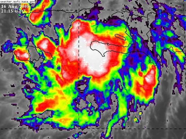
Lots of deep convection trailing the main LLC, pretty classic sign of a system that has been over some large mountions fairly recently, I'd have thought that convection will explode back over the center in about 6-9hrs time providing its not inland again by that point which is possible given that little SE tip of Cuba.
0 likes   

User avatar
Bgator
Category 2
Category 2
Posts: 649
Joined: Mon Sep 05, 2005 12:29 pm
Location: Orlando, FL

#5619 Postby Bgator » Sat Aug 16, 2008 5:16 pm

Well, it seems that Fay is the only story on Miami news. Watching channel 6, all they are talking about...
0 likes   

tolakram
Admin
Admin
Posts: 20165
Age: 62
Joined: Sun Aug 27, 2006 8:23 pm
Location: Florence, KY (name is Mark)

Re: ATL: Tropical Storm Fay

#5620 Postby tolakram » Sat Aug 16, 2008 5:17 pm

http://hadar.cira.colostate.edu/ramsdis ... ive_0.html

Looks to be moving just a tad north of west. At this angle it might miss land. Any comments on this? Am I looking at it right?
0 likes   


Return to “2008”

Who is online

Users browsing this forum: No registered users and 32 guests