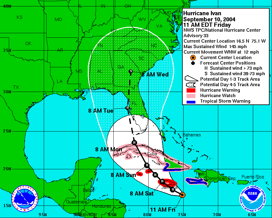
ATL: Tropical Depression Fay

Moderator: S2k Moderators

Message
Author
User avatar
KWT
Category 5
Category 5
Posts: 31416
Joined: Tue Aug 17, 2004 11:02 am
Location: UK!!!

Re: ATL: Tropical Storm Fay

#5781 Postby KWT » Sat Aug 16, 2008 7:37 pm

KWT wrote:
Jason_B wrote:Actually it is already moving slightly north of west, so a solid wnw movement should take place tomorrow and eventually NW just like the models are showing. No reason for the models to shift any further west than they are right now.


Yeah maybe its hard to say as the center is bound to wobble around and stair step to some degree at least but the 2hr mean from what recon showed was due west for what its worth.


Saying that longer term motion is indeed probably between 275-280 degrees over the past 9-12hrs, thats probably what really needs to be watched rather then short term wobbles and jogs.
0 likes   

Dean4Storms
S2K Supporter
S2K Supporter
Posts: 6358
Age: 62
Joined: Sun Aug 31, 2003 1:01 pm
Location: Miramar Bch. FL

Re: ATL: Tropical Storm Fay

#5782 Postby Dean4Storms » Sat Aug 16, 2008 7:37 pm

Jason_B wrote:This is not going to hit Pensacola.


Where do we buy your Crystal Ball?

P'Cola is still within the range of possibilities and within the NHC Cone last I saw. It is however at the moment a slim possiblity.
0 likes   

Frank P
S2K Supporter
S2K Supporter
Posts: 2779
Joined: Fri Aug 29, 2003 10:52 am
Location: Biloxi Beach, Ms
Contact:

Re: Cuba Radars

#5783 Postby Frank P » Sat Aug 16, 2008 7:38 pm

Steve Cosby wrote:Most of the links to the Cuban radars seemed to be off so here's the link that really works - all the radars are accessed from here:

http://www.insmet.cu/asp/genesis.asp?TB0=PLANTILLAS&TB1=RADARES


this one was working...

http://www.insmet.cu/asp/genesis.asp?TB ... axw01a.gif

from what I can see it is still moving west... or at least some part of it..
0 likes   

Shockwave
Tropical Storm
Tropical Storm
Posts: 167
Joined: Fri Jul 25, 2008 7:33 am
Location: Lafayette, TN
Contact:

Re: ATL: Tropical Storm Fay

#5784 Postby Shockwave » Sat Aug 16, 2008 7:38 pm

Jason_B wrote:This is not going to hit Pensacola.


Can you give some evidence to your confident answer? I'm still not discounting the fact of a Pensacola landfall.
0 likes   

User avatar
abajan
S2K Supporter
S2K Supporter
Posts: 4305
Age: 61
Joined: Sun Sep 07, 2003 5:10 am
Location: Barbados

Re: ATL: Tropical Storm Fay

#5785 Postby abajan » Sat Aug 16, 2008 7:40 pm

Jason_B wrote:This is not going to hit Pensacola.
Ought that not to be preceded by the S2K disclaimer, Jason_B?
0 likes   

User avatar
Ivanhater
Storm2k Moderator
Storm2k Moderator
Posts: 11165
Age: 38
Joined: Fri Jul 01, 2005 8:25 am
Location: Pensacola

Re: ATL: Tropical Storm Fay

#5786 Postby Ivanhater » Sat Aug 16, 2008 7:41 pm

New bams out... bamd shift to west panhandle

Image
0 likes   

User avatar
artist
Category 5
Category 5
Posts: 9792
Joined: Mon Jun 06, 2005 3:26 pm
Location: West Palm

#5787 Postby artist » Sat Aug 16, 2008 7:41 pm

0 likes   

User avatar
cycloneye
Admin
Admin
Posts: 148496
Age: 69
Joined: Thu Oct 10, 2002 10:54 am
Location: San Juan, Puerto Rico

Re: ATL: Tropical Storm Fay

#5788 Postby cycloneye » Sat Aug 16, 2008 7:42 pm

Getting organized:

Image
0 likes   

User avatar
artist
Category 5
Category 5
Posts: 9792
Joined: Mon Jun 06, 2005 3:26 pm
Location: West Palm

#5789 Postby artist » Sat Aug 16, 2008 7:44 pm

does it not look like the center is just on shore there?
0 likes   

Dean4Storms
S2K Supporter
S2K Supporter
Posts: 6358
Age: 62
Joined: Sun Aug 31, 2003 1:01 pm
Location: Miramar Bch. FL

Re: ATL: Tropical Storm Fay

#5790 Postby Dean4Storms » Sat Aug 16, 2008 7:44 pm

Ivanhater wrote:New bams out... bamd shift to west panhandle

Image


Yep, I saw that earlier and that was what I was referencing about all the BAMM models and others being toward the Panhandle now. We have the NOGAPS, UKMET and all the BAMM models swinging this way.
0 likes   

User avatar
KWT
Category 5
Category 5
Posts: 31416
Joined: Tue Aug 17, 2004 11:02 am
Location: UK!!!

#5791 Postby KWT » Sat Aug 16, 2008 7:45 pm

BAMD is way west, not sure why that would be the case mind you?

Also current mean direction is indeed 270 according to the latest data, exactly due west.
0 likes   

caneman

Re: ATL: Tropical Storm Fay

#5792 Postby caneman » Sat Aug 16, 2008 7:45 pm

Ivanhater wrote:BTW here is a track for Ivan

Image


That was more than a 96 hour forecast. We're now under 72 hours is GFS is right maybe even 66 hours for West coast landfall so you would expect a wider margin of error..
Last edited by caneman on Sat Aug 16, 2008 7:46 pm, edited 1 time in total.
0 likes   

User avatar
Steve
S2K Supporter
S2K Supporter
Posts: 9628
Joined: Sat Apr 05, 2003 11:41 pm
Location: Gulf of Gavin Newsom

#5793 Postby Steve » Sat Aug 16, 2008 7:45 pm

>>BTW here is a track for Ivan

First night I ever drank Absinthe as the city went under a curfew and I was on my bike. 5 mile ride home, despite a 30mph wind at my back, was still a little sketchy. :D

To stay on topic, here's a link the highres IR out of UWash.
http://www.atmos.washington.edu/cgi-bin/latest.cgi?ir-e
0 likes   

Matt-hurricanewatcher

Re: ATL: Tropical Storm Fay

#5794 Postby Matt-hurricanewatcher » Sat Aug 16, 2008 7:47 pm

Any news out of Hati/DR?

Another 2 degree's at a westward motion will give it another day over super hot waters.
0 likes   

User avatar
Ivanhater
Storm2k Moderator
Storm2k Moderator
Posts: 11165
Age: 38
Joined: Fri Jul 01, 2005 8:25 am
Location: Pensacola

Re:

#5795 Postby Ivanhater » Sat Aug 16, 2008 7:48 pm

Steve wrote:>>BTW here is a track for Ivan

First night I ever drank Absinthe as the city went under a curfew and I was on my bike. 5 mile ride home, despite a 30mph wind at my back, was still a little sketchy. :D

To stay on topic, here's a link the highres IR out of UWash.
http://www.atmos.washington.edu/cgi-bin/latest.cgi?ir-e


Haaaa, heard that stuff was good, thought it was illegal in the states tho :wink:

looking forward to the 00z models..my best bet is still the western big bend area
0 likes   

User avatar
KWT
Category 5
Category 5
Posts: 31416
Joined: Tue Aug 17, 2004 11:02 am
Location: UK!!!

#5796 Postby KWT » Sat Aug 16, 2008 7:50 pm

Yeah caneman, still closeness to the actual time doesn't make a huge difference, I mean look how far away Katrina was when it dived SW compared to the guidence just 36hrs before, only one model picked up on that and that was the GFDL.

What should be noted is there is some slight shift from the models back and forth but the general track is unaltered, a turn to the north, maybe slightly east of north toward west Florida, or maybe eastern panhandle if it goes far enough west.
0 likes   

jinftl
Category 5
Category 5
Posts: 4312
Joined: Tue Aug 31, 2004 4:47 pm
Location: fort lauderdale, fl

Re: ATL: Tropical Storm Fay

#5797 Postby jinftl » Sat Aug 16, 2008 7:50 pm

Plus if you don't fixate on the black line....the eventual landfall point for ivan was in the cone even 5 days out....if you take away the black line for fay's 5-day....all the model runs, even the ones showing more west, are in the cone!

caneman wrote:
Ivanhater wrote:BTW here is a track for Ivan

Image


That was more than a 96 hour forecast. We're now under 72 hours is GFS is right maybe even 66 hours for West coast landfall so you would expect a wider margin of error..
0 likes   

User avatar
Bgator
Category 2
Category 2
Posts: 649
Joined: Mon Sep 05, 2005 12:29 pm
Location: Orlando, FL

Re: ATL: Tropical Storm Fay

#5798 Postby Bgator » Sat Aug 16, 2008 7:52 pm

Try not to pay attention to the BAMM models, it has only been said a million times, that they are close to useless in situations like this. GFS, GFDL, Euro, and other global models should be the ones looked at with higher confidence.
0 likes   

tallywx
Category 2
Category 2
Posts: 798
Joined: Thu Jul 03, 2003 10:19 am
Location: Raleigh/Durham, NC

Re:

#5799 Postby tallywx » Sat Aug 16, 2008 7:53 pm

artist wrote:does it not look like the center is just on shore there?


No, what you're seeing in that radar pic is ground clutter from the radar beam. That's not actually a core of precipitation but ground clutter around the radar site. You have to filter that out in your mind.
0 likes   

fasterdisaster
Category 5
Category 5
Posts: 1868
Joined: Mon Sep 19, 2005 4:41 pm
Location: Miami, Florida

#5800 Postby fasterdisaster » Sat Aug 16, 2008 7:53 pm

In a scenario that this were to go into SE Florida and then up the EC before hitting NC, are the waters suitable for strengthening off the coast?
0 likes   


Return to “2008”

Who is online

Users browsing this forum: No registered users and 36 guests