the "eye level feature" on satelite......then yes i agree
the recon just flew right by fay to the south (east to west) i wonder if they can't get any closer to cuba
ATL: Tropical Depression Fay
Moderator: S2k Moderators


-
fasterdisaster
- Category 5

- Posts: 1868
- Joined: Mon Sep 19, 2005 4:41 pm
- Location: Miami, Florida
-
Wx_Warrior
- Category 5
- Posts: 2718
- Joined: Thu Aug 03, 2006 3:58 pm
- Location: Beaumont, TX
Re: ATL: Tropical Storm Fay South of Cuba
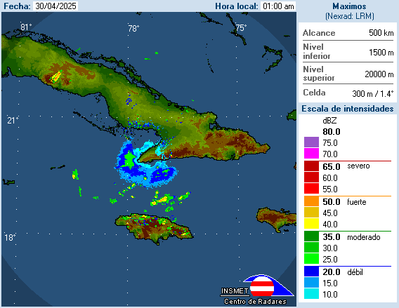
Radar shows not a whole lot to get excited about. As I said a few days ago, these islands would inhibit and I got laffed off the board. 
Last edited by Wx_Warrior on Sun Aug 17, 2008 1:30 am, edited 1 time in total.
0 likes
-
Matt-hurricanewatcher
Re: ATL: Tropical Storm Fay South of Cuba
Looks like it got its innercore back. But now it is going to get its lights punched out by the mountains, in which case will slow it down some. It is a wait and see.
0 likes
-
cheezyWXguy

- Category 5
- Posts: 6282
- Joined: Mon Feb 13, 2006 12:29 am
- Location: Dallas, TX
Re:
fasterdisaster wrote:Nice? She looks terrible.
No she doesnt. Covered by deep convection, exceptional outflow, etc. Sure a CDO has not yet condensed, but what do you expect out of a system that has had to deal with land interaction its entire life?
0 likes
-
cheezyWXguy
- Category 5
- Posts: 6282
- Joined: Mon Feb 13, 2006 12:29 am
- Location: Dallas, TX
Re: ATL: Tropical Storm Fay South of Cuba
Wx_Warrior wrote:Radar shows not a whole lot to get excited about. As I said a few days ago, these islands would inhibit and I got laffed off the board.
Well its strengthening now, and the center is actually definable for the pretty much the first time. As for cuba, I expect a light brussing with cuba for just a couple hours, nothing that would really make it lose strength. I think this could be a strong ts by tomorrow late afternoon.
0 likes
Re: ATL: Tropical Storm Fay South of Cuba
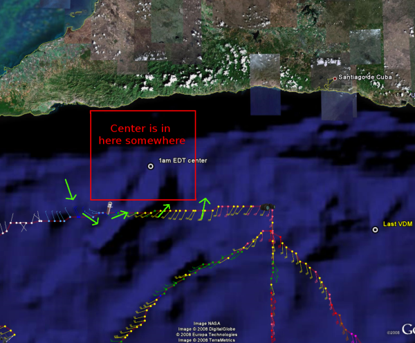
not sure if that's the center ARIC recon seems to show a system lacking much of a SW side
and a center somewhere just north of 19.3 76.9 or so
and a center somewhere just north of 19.3 76.9 or so
0 likes


Re: Re:
Matt-hurricanewatcher wrote:fasterdisaster wrote:Nice? She looks terrible.
Much better organizion then it had earlier.
I agree, terrible was Sat morning, when most deep convection was well S of the LLC, so compared to then Fay looks much better, not the best but much better.
0 likes
Re: ATL: Tropical Storm Fay South of Cuba
Using IR2 it is VERY easy to track the progress of the center before the eclipse...
http://www.ssd.noaa.gov/goes/flt/t1/sloop-ir2.html
However...after...it is much harder because of all of the thunderstorms over the center. My guess is the center is just off of the coast...near 19.5N 76.8W,
MW
http://www.ssd.noaa.gov/goes/flt/t1/sloop-ir2.html
However...after...it is much harder because of all of the thunderstorms over the center. My guess is the center is just off of the coast...near 19.5N 76.8W,
MW
0 likes


http://weather.noaa.gov/weather/current/MKJP.html
Kingston, Jamaica currently reporting winds out of the NNE at 6mph, and before that, winds out of the ENE at 10mph.
Edited to add: not much winds, but those directions are a puzzle.
Kingston, Jamaica currently reporting winds out of the NNE at 6mph, and before that, winds out of the ENE at 10mph.
Edited to add: not much winds, but those directions are a puzzle.
0 likes
Re:
alicia83 wrote:http://weather.noaa.gov/weather/current/MKJP.html
Kingston, Jamaica currently reporting winds out of the NNE at 6mph, and before that, winds out of the ENE at 10mph.
Edited to add: not much winds, but those directions are a puzzle.
Winds in Kingston have been from all over in the last few hours, not just N or E, because of convection right on top of them, they are in converging zone so winds will be from all over
0 likes
-
fasterdisaster
- Category 5
- Posts: 1868
- Joined: Mon Sep 19, 2005 4:41 pm
- Location: Miami, Florida
Re: ATL: Tropical Storm Fay South of Cuba
NDG, thanks for the explaination. I should've recognized that!
0 likes
Who is online
Users browsing this forum: No registered users and 227 guests