cycloneye wrote:
ATL: Tropical Depression Fay
Moderator: S2k Moderators
Re: ATL: Tropical Storm Fay South of Cuba
Last edited by cpdaman on Sun Aug 17, 2008 8:19 am, edited 2 times in total.
0 likes


Re: ATL: Tropical Storm Fay South of Cuba
cpdaman wrote:convection on the decline
interesting to me the shady radar shows a center still at the SW tip near mountains but NHC has it a bit to the west, one thing is sure about fay she is a mess, she always has been, and HOPEFULLY she always will be.
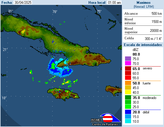
Oh, that is just the cone of silence associated with the radar beam and its proximity to the radar site. It is larger for the Cuban radars due to their poorer quality. If you loop the image, though, you can see that all the rain is moving from south to north in that area, indicating that the LLC is farther to the WNW -- where the NHC placed it at 8 AM.
Last edited by ekal on Sun Aug 17, 2008 8:19 am, edited 1 time in total.
0 likes

Re: ATL: Tropical Storm Fay South of Cuba
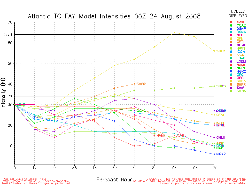
Latest intensity forecast - SHPS takes it to near 80 kts perior to LF. The GFNL, the Navy model, which keeps Fay just offshore for a big bend LF approaches CAT 4 status. The GFDL and HWRF are low due to the cuban land interaction and NE turn over S FL.
0 likes
-
vbhoutex

- Storm2k Executive

- Posts: 29147
- Age: 74
- Joined: Wed Oct 09, 2002 11:31 pm
- Location: Cypress, TX
- Contact:
Re:
HURAKAN wrote:
You can see where the tallest peak is.

Repeated from many pages ago. Thanks Hurakan. The tallest "peaks" are now to the East of the center. The hills in the central part of the country do not appear to be much of a threat to Fay, imo.
0 likes

Re: ATL: Tropical Storm Fay South of Cuba
I actually see a low level center racing WNW along the Cuban coast now....maybe its hallucinations though
0 likes
-
cycloneye

- Admin
- Posts: 149405
- Age: 69
- Joined: Thu Oct 10, 2002 10:54 am
- Location: San Juan, Puerto Rico
Re: Re:
vbhoutex wrote:HURAKAN wrote:
You can see where the tallest peak is.
Repeated from many pages ago. Thanks Hurakan. The tallest "peaks" are now to the East of the center. The hills in the central part of the country do not appear to be much of a threat to Fay, imo.
And in the Western part is almost flat,so Fay will not have to deal with tall peaks.
0 likes
-
Extremeweatherguy

- Category 5

- Posts: 11095
- Joined: Mon Oct 10, 2005 8:13 pm
- Location: Florida
Re: TS Fay Personal forecasts
TROPICAL STORM FAY FORECAST (8-17-08 11AM)

Track: Fay is starting to find the weakness in the ridge and should begin to turn WNW, then NW and finally N or NNE in response. This motion should take the storm toward the western coast of Florida.
Strength: Fay will continue to have favorable upper-level conditions for development today and moderately favorable upper-level conditions for development tomorrow. Because of this, the storm should be able to slowly gain strength over the next 48 hours prior up until landfall. The only real inhibitor to development will be land interaction today and tonight, and then some light southwesterly shear tomorrow.
Final Landfall: The final landfall location should be somewhere between Port Charlotte and Tampa, with the city of Englewood currently being the most likely spot of landfall.
INTENSITY FORECAST:
INITIAL: 45KT (52mph)
11PM SUNDAY: 60KT (69mph)
11AM MONDAY: 55KT (63mph)
11PM MONDAY: 65KT (75mph)
8-9AM LANDFALL: 75KT (86mph)
11AM TUESDAY: 65KT (75mph)
11PM TUESDAY: 45KT (52mph)
11AM WEDNESDAY: 30KT (35mph)
11PM WEDNESDAY: REMNANT LOW
0 likes
-
johngaltfla

- Category 5
- Posts: 2073
- Joined: Sun Jul 10, 2005 9:17 pm
- Location: Sarasota County, FL
- Contact:
Re: ATL: Tropical Storm Fay South of Cuba
Once Fay clears the eastern tip of Cuba completely then crosses is when our lives get interesting. I'm wondering just how fast the pressures may drop between Key West and Cuba.
0 likes


Re: ATL: Tropical Storm Fay South of Cuba
Normandy wrote:I actually see a low level center racing WNW along the Cuban coast now....maybe its hallucinations though
should that hallucination be based on radar like mine was earlier, than that is all it is, there is a blank spot in the cuban radar and all the echoes are actually moving north, so that is not the center as EKAL explained to me. If that is not the reason, then what makes you think the center is down there
0 likes
Re: ATL: Tropical Storm Fay South of Cuba
this cuba locale's radar should be picking up the center better as the moring goes on
http://www.insmet.cu/asp/genesis.asp?TB ... AXw01a.gif
http://www.insmet.cu/asp/genesis.asp?TB ... AXw01a.gif
Last edited by cpdaman on Sun Aug 17, 2008 8:34 am, edited 2 times in total.
0 likes
Re: ATL: Tropical Storm Fay South of Cuba
Latest intensity forecast - SHPS takes it to near 80 kts perior to LF. The GFNL, the Navy model, which keeps Fay just offshore for a big bend LF approaches CAT 4 status. The GFDL and HWRF are low due to the cuban land interaction and NE turn over S FL.
DSHP keeps Fay below 60 knots, though, which is the SHPS adjusted for land interaction.
0 likes


Re: Re:
cycloneye wrote:vbhoutex wrote:HURAKAN wrote:
You can see where the tallest peak is.
Repeated from many pages ago. Thanks Hurakan. The tallest "peaks" are now to the East of the center. The hills in the central part of the country do not appear to be much of a threat to Fay, imo.
And in the Western part is almost flat,so Fay will not have to deal with tall peaks.
By going by the NHC forecast track of making landfall west of Cienfuegos Fay will come in a part of Cuba that is either flat & swampy or plain all flat, with just some higher elevations of 300', but if it makes landfall a little east between Cienfuegos & Trinidad, Fay will be coming across a spotty mountainous area that its highest elevetions are 2,500', which I doubt will affect it much anyway.
Last edited by NDG on Sun Aug 17, 2008 8:35 am, edited 1 time in total.
0 likes
Re: ATL: Tropical Storm Fay South of Cuba
39 hours now and still in the bullseye. In all my years of storm watching I've never seen a track zone in like this and not change. Nice calm beautiful warm sunny Sunday morning here under blue skies.
Fay is so weak it allowed a ULL to form to its WNW. This is partially dampening development. Fay took a real accumulative hit from those 10,000 foot peaks on Hispaniola.
The slowdown some of us saw last night was correct. And I see NHC takes the intensity forecast down to tropical storm off Sanibel. I think this could be a recipe for disaster because Fay is just in its day time d-min right now. A TS prediction could make people dismiss Fay and allow it to sneak slowly over those high heat potential waters and boom.
Hard to say, Fay has been very difficult and stayed right on the NHC trop points even though it looked like it should tick slightly right from its behavior. (WRONG!)
Don't underestimate Fay. It still has that good convection mass just waiting for reorganization. The key here being the NHC track will bring the ULL to Fay's SW which is a classic venting orientation while Fay crosses high heat waters at slow speed. I would ignore all intensity predictions and treat Fay as dangerous - even if it doesn't happen.
Will this slowness shift the track east?
Last edited by Sanibel on Sun Aug 17, 2008 8:45 am, edited 1 time in total.
0 likes

Re: ATL: Tropical Storm Fay South of Cuba
someone mentioned people not taking it as seriously up here in the tampa bay area as those in south fl. I am one of those. If you knew how many times nhc has cried wolf(not their fault these storms have a mind of their own) saying tampa will be hit and if one did hit it would be a brush or downgraded into a ts. It will be after it crosses and everyone knows where's its going before I get excited. I just have a hard time believing this is going to amount to more than an inconvenience of heavy rains and maybe some squall bands. I don't want the rain our area has been saturated this year. I wish it would've got to miami and lake ocochobee where they really need the rain well i guess they will get it. And tampa will not be on the dirty side of the storm if the center is east of the bay. We will be on the weaker side. points east will deal with the tornadoes. Mark my words, it's not going to be that bad in tampa bay maybe southwest fl will get the brunt or maybe it will do a charley track. However, this is strictly my opinion and this is not a forecast so people take it with a grain of salt and everyone should already be prepared.
0 likes
Re: ATL: Tropical Storm Fay South of Cuba
well the uLL was nearly stationary yesterday but today it' on the move westward
so i think now is fay's first time to shine in a while , she should be over water (less impeeded by land than yesterday or last nite) and for at least 12 hours .
so i think now is fay's first time to shine in a while , she should be over water (less impeeded by land than yesterday or last nite) and for at least 12 hours .
0 likes

Who is online
Users browsing this forum: No registered users and 25 guests