
ATL: Tropical Depression Fay
Moderator: S2k Moderators
-
Pearl River

- S2K Supporter

- Posts: 825
- Age: 67
- Joined: Fri Dec 09, 2005 6:07 pm
- Location: SELa
Re: ATL: Tropical Storm Fay South of Cuba
I don't see how anyone can say it's moving NW or N-NW based on radar with 4 frames, taken every 15 minutes. But, I guess my eyes are too old.
0 likes

Re: ATL: Tropical Storm Fay South of Cuba
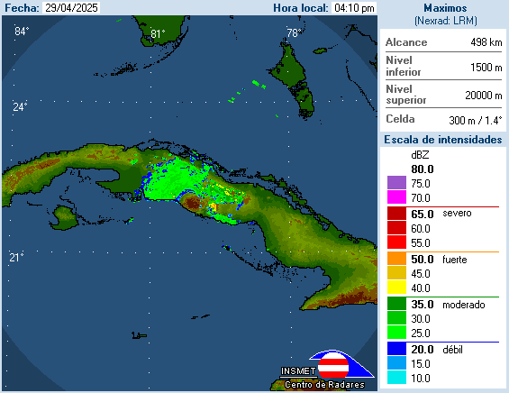
AdamFirst wrote:Here's the Cuban radar mosaic, probably answers a few questions
http://www.insmet.cu/asp/genesis.asp?TB ... p200Km.gif
unfortunately, a one hour loop doesn't help much.
0 likes
Re:
KWT wrote:cpdaman , the LLC is getting hrader to track because its finally got some deepening convection over it again, the deepest convection is to its east still but now its starting to finally get rid of that terribly sheared look it had about 6hrs ago, still not classic but the convection slowly alining with the center again.
Still only see a WNW track as well...
look at the radar KWT!
as i thought it built back eastward
at 530 recon found the center at 20 53 (20.9 n) 80 10 (80.2 w)
now at 718 they find the center at 20 55 ........ 80 04 (80.1)w
now obviously you can't extract a heading from this, but the point is that the center is still forming and it is trending toward building back toward the convection a bit to the east.
Last edited by cpdaman on Sun Aug 17, 2008 6:24 pm, edited 1 time in total.
0 likes
-
SouthFLTropics

- Category 5

- Posts: 4258
- Age: 50
- Joined: Thu Aug 14, 2003 8:04 am
- Location: Port St. Lucie, Florida
Re: ATL: Tropical Storm Fay South of Cuba
eastcoastFL wrote:i definetly agree with nnw heading
Off Topic...Hello fellow PSL poster
Now back to your regularly scheduled TS Fay discussion
0 likes

Re:
HurricaneHunter914 wrote:I think it would help if we had a pro met tell us the heading. What a trooper Fay is. From looking terrible this morning, too looking very better organized this evening. IMO, even if Fay is heading NW or NNW, that area of Cuba is very mountanous and will probably have not too much of an affect.
The posts in this forum are NOT official forecast and should not be used as such. They are just the opinion of the poster and may or may not be backed by sound meteorological data. They are NOT endorsed by any professional institution or storm2k.org. For official information, please refer to the NHC and NWS products.
Its already too far west to go thru mountain areas. As far as the heading, we need to observe it for an hour or 2 at least to make sure its really a turn and not just a wobble or jog. It is impossible to say what corse a storm is on, and "current" course is at least 2 hours old, at least this is what my buddy says, who IS a pro met.
0 likes
-
Hurricanewatcher2007

- Category 2

- Posts: 578
- Joined: Sat Jul 05, 2008 8:10 pm
Re: ATL: Tropical Storm Fay South of Cuba
Noles2006 wrote:Hurricanewatcher2007 wrote:Looking on Radar I don't see much of any movement. I think what some are seeing as a north movement is the convection from the east wrapping around to the north.
I agree - I do not think they are correctly identifying the true center.
based on the radar the center really can't be missed so I don't think its that people aren't locating the true center its just that the convection wrapping to the north makes it look like Fay is moving more north then she really is. but if you pin point the exact center you will see that its really not moving to much at all.
0 likes

Re: Re:
capepoint wrote:HurricaneHunter914 wrote:I think it would help if we had a pro met tell us the heading. What a trooper Fay is. From looking terrible this morning, too looking very better organized this evening. IMO, even if Fay is heading NW or NNW, that area of Cuba is very mountanous and will probably have not too much of an affect.
The posts in this forum are NOT official forecast and should not be used as such. They are just the opinion of the poster and may or may not be backed by sound meteorological data. They are NOT endorsed by any professional institution or storm2k.org. For official information, please refer to the NHC and NWS products.
Its already too far west to go thru mountain areas. As far as the heading, we need to observe it for an hour or 2 at least to make sure its really a turn and not just a wobble or jog. It is impossible to say what corse a storm is on, and "current" course is at least 2 hours old, at least this is what my buddy says, who IS a pro met.
especially without a good radar AND/OR a clear eye
0 likes
-
Frank P
- S2K Supporter
- Posts: 2779
- Joined: Fri Aug 29, 2003 10:52 am
- Location: Biloxi Beach, Ms
- Contact:
Re:
KWT wrote:I think why people think its headingNW is because finally convection is arching over the center and even onto the western quadrant and with some slight shear still it gives the illusion of the system moving NW.
good point... I'm just looking at the overall system and it appears to be moving wnw or something close to that.. that's NOT to say the LLC is moving that direction as I can't see it, it could be slowing down or moving NW, I have no idea.. However, put this loop in motion, at a high speed, don't zoom in, and move back from the screen, you decide its motion... my opinion FWIW
http://www.ssd.noaa.gov/goes/flt/t1/loop-rgb.html
0 likes
-
tolakram
- Admin

- Posts: 20185
- Age: 62
- Joined: Sun Aug 27, 2006 8:23 pm
- Location: Florence, KY (name is Mark)
Re: ATL: Tropical Storm Fay South of Cuba
I'm a bit late with my chart.
It's taken a turn and slowed down, but I noticed the latest track has changed west again. I've been away most of the day, going to have to catch up.
5PM forecast advisory:
TROPICAL STORM CENTER LOCATED NEAR 21.0N 80.2W AT 17/2100Z
POSITION ACCURATE WITHIN 30 NM
PRESENT MOVEMENT TOWARD THE WEST-NORTHWEST OR 300 DEGREES AT 13 KT
ESTIMATED MINIMUM CENTRAL PRESSURE 1003 MB
MAX SUSTAINED WINDS 45 KT WITH GUSTS TO 55 KT.
0 likes

5.30 was a bad vortex by the way, they found winds of 12kts meaning that wasn't the true center...still even so not going to argue that its slowed alot.
Lets just say its still west from where the 2nd vortex dropped which was a perfect landing into the center...
Recon can't lie and can't give illusions, it is what it is and its says the LLC has moved over the last 3-4hrs pretty much west...I'd guess probably 280-285 degrees.
Lets just say its still west from where the 2nd vortex dropped which was a perfect landing into the center...
Recon can't lie and can't give illusions, it is what it is and its says the LLC has moved over the last 3-4hrs pretty much west...I'd guess probably 280-285 degrees.
Last edited by KWT on Sun Aug 17, 2008 6:26 pm, edited 2 times in total.
0 likes
-
CalmBeforeStorm

- Category 2
- Posts: 600
- Age: 72
- Joined: Tue Aug 10, 2004 7:55 pm
- Location: Stuart, Florida
http://www.ssd.noaa.gov/goes/flt/t1/loop-avn.html
~~~~~~~~~~~
Looking at IR the deep convection has not moved for close to 8 hours. If the center is still moving WNW then it would be outracing the convection and the storm would be becoming more disorganized. The satellite presentation suggests it is getting better organized so I would suggest Fay is hardly moving and is in the process of reorganizing under the deep convection.
0 likes
Re: Re:
cpdaman wrote:KWT wrote:cpdaman , the LLC is getting hrader to track because its finally got some deepening convection over it again, the deepest convection is to its east still but now its starting to finally get rid of that terribly sheared look it had about 6hrs ago, still not classic but the convection slowly alining with the center again.
Still only see a WNW track as well...
look at the radar KWT!
as i thought it built back eastward
at 530 recon found the center at 20 53 (20.9 n) 80 10 (80.2 w)
now at 718 they find the center at 20 55 ........ 80 04 (80.1)w
If thats true its basically not moved in the last few hours.. The shift NW was expected today.. is that an indication its about to happen?
0 likes
Re: Re:
HURAKAN wrote:lbvbl wrote:HURAKAN wrote:In the case of Miami-Dade, you could have classes but you would expose children to strong gusts and heavy rains found in the squalls that will be moving over the county tomorrow.
Yeah I can understand the reasoning for Miami-dade... What do you think about PBC schools on tuesday? Depending on the track it takes, the northern part of the county could be affected.
Is always better safe than sorry.
IMO, there is NO way school will be cancelled in Palm Beach County for squalls from a storm that will be about 125-150 miles away and not moving towards us.
I think Miami-Dade jumped the gun and should not have cancelled school and if they had to do it again they would reverse their decision.
Just my opinion.
0 likes


Re: ATL: Tropical Storm Fay South of Cuba
The center isn't moving because its being pulled into the deep convection to the east. The whole mass itself is still moving but the center was so far displaced earlier that it gives the illusion of a stall. If Fay puts her center completely under deep convection I'd venture to say it might get close to cane status before hitting Cuba.
0 likes

I think the overall circulation is probably moving more WNW but the LLC is probably still heading only a little north of west, I think its only a matter of time before it also lifts WNW/NW as well.
However as I said before the vortex before this was not correct, they slightly missed the center on the dropsonde as they got 12kts winds suggesting the center was a little further east of where they dropped.
Still it has really slowed down lately, probably won't be long before it starts to turn more towards the NW.
Edit---also god knows why people are using radar instead of recon obs!
Last edited by KWT on Sun Aug 17, 2008 6:29 pm, edited 3 times in total.
0 likes
Re: ATL: Tropical Storm Fay South of Cuba
TS Fay will continue moving WNW to NW until the system deepens. Being a weak, more shallow, tropical storm, Fay is currently under influence of easterly winds that extend from the surface with more east-southeast to south-east winds extending from H95 to around H70. In the mid-levels (H50) the steering winds are almost due south. Therefore, as Fay strengthens, the storm will become more influenced by southerly flow aloft, which would turn the storm northward. If the storm strengthens quicker than forecast, then an earlier turn would take place. Conversely, more delayed strengthening would lead to a farther west tracking storm - assuming that the system maintains a forward motion. Certainly in the complex steering regime a slowed forward motion, or stall, is possible.
- Jay
- Jay
0 likes
Re: Re:
tgenius wrote:cpdaman wrote:KWT wrote:cpdaman , the LLC is getting hrader to track because its finally got some deepening convection over it again, the deepest convection is to its east still but now its starting to finally get rid of that terribly sheared look it had about 6hrs ago, still not classic but the convection slowly alining with the center again.
Still only see a WNW track as well...
look at the radar KWT!
as i thought it built back eastward
at 530 recon found the center at 20 53 (20.9 n) 80 10 (80.2 w)
now at 718 they find the center at 20 55 ........ 80 04 (80.1)w
If thats true its basically not moved in the last few hours.. The shift NW was expected today.. is that an indication its about to happen?
no i wouldn't jump on that train (although quite possible), indicates especially that the center had some organizing to do and it's not racing anywhere
Last edited by cpdaman on Sun Aug 17, 2008 6:30 pm, edited 1 time in total.
0 likes
-
DESTRUCTION5

- Category 5
- Posts: 4430
- Age: 44
- Joined: Wed Sep 03, 2003 11:25 am
- Location: Stuart, FL
Re:
NDG wrote:Radar presention is looking better, Fay has really slowed down to a crawl relocating closer to the convection, a change is course is coming soon.
She's taking a bath in 92 degee water ATM..
0 likes
Who is online
Users browsing this forum: Google Adsense [Bot] and 12 guests