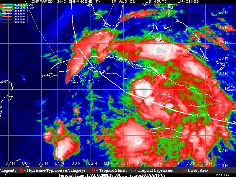
NEXRAD wrote:From the 7-hour Pico de San Juan radar time-lapse, it seems that Fay is slowly moving NNW to me.
- Jay
I agree straight towards those few high mountain peaks...
Moderator: S2k Moderators


NEXRAD wrote:From the 7-hour Pico de San Juan radar time-lapse, it seems that Fay is slowly moving NNW to me.
- Jay


NEXRAD wrote:From the 7-hour Pico de San Juan radar time-lapse, it seems that Fay is slowly moving NNW to me.
- Jay

AJC3 wrote:7-hour time lapse of Fay from the Pico De San Juan Radar...

NEXRAD wrote:Some recent effects from (semi-from) Fay
Although strictly speaking Fay's influence is not entirely established over the South Florida Peninsula just yet, I find it worthwhile to pass-along today's NWSFO storm reports...
PRELIMINARY LOCAL STORM REPORT
NATIONAL WEATHER SERVICE TAMPA BAY AREA - RUSKIN FL
826 PM EDT SUN AUG 17 2008
..TIME... ...EVENT... ...CITY LOCATION... ...LAT.LON...
..DATE... ....MAG.... ..COUNTY LOCATION..ST.. ...SOURCE....
..REMARKS..
0645 PM FLOOD CAPE CORAL 26.58N 81.99W
08/17/2008 LEE FL FIRE DEPT/RESCUE
FIRE RESCUE REPORTED MODERATE STREET FLOODING IN CAPE
CORAL.
0650 PM FUNNEL CLOUD 1 NW NORTH FORT MYERS 26.72N 81.90W
08/17/2008 LEE FL PUBLIC
FUNNEL CLOUD REPORTED JUST NORTHWEST OF SUNCOAST ESTATES.
And from Key West NWSFO... wind gusts to 41-mph, Marathon, 43-mph, Key West, and 48-mph, Key Largo with an outflow boundary from weakened convection that formed along Fay's peripheries earlier today.
- Jay

I think the LLC is just to the left of those strongest thunderstorms. Still looks to be moving NW or NNW though either way.Bgator wrote:NEXRAD wrote:From the 7-hour Pico de San Juan radar time-lapse, it seems that Fay is slowly moving NNW to me.
- Jay
Me too, im assuming that the llc is where the stronger curved thunderstorm is.

Stangfriik wrote:NEXRAD wrote:Some recent effects from (semi-from) Fay
Although strictly speaking Fay's influence is not entirely established over the South Florida Peninsula just yet, I find it worthwhile to pass-along today's NWSFO storm reports...
PRELIMINARY LOCAL STORM REPORT
NATIONAL WEATHER SERVICE TAMPA BAY AREA - RUSKIN FL
826 PM EDT SUN AUG 17 2008
..TIME... ...EVENT... ...CITY LOCATION... ...LAT.LON...
..DATE... ....MAG.... ..COUNTY LOCATION..ST.. ...SOURCE....
..REMARKS..
0645 PM FLOOD CAPE CORAL 26.58N 81.99W
08/17/2008 LEE FL FIRE DEPT/RESCUE
FIRE RESCUE REPORTED MODERATE STREET FLOODING IN CAPE
CORAL.
0650 PM FUNNEL CLOUD 1 NW NORTH FORT MYERS 26.72N 81.90W
08/17/2008 LEE FL PUBLIC
FUNNEL CLOUD REPORTED JUST NORTHWEST OF SUNCOAST ESTATES.
And from Key West NWSFO... wind gusts to 41-mph, Marathon, 43-mph, Key West, and 48-mph, Key Largo with an outflow boundary from weakened convection that formed along Fay's peripheries earlier today.
- Jay
Wow Jay, my family must be having quite the time in the Key's then. They arrived there yesterday even though I told them that there would be a evac order either that day or today. Even though there is an order, they said that since they are on the opposite side of the island (not sure which one they are on), it should be okay. I kept reminding my mother that they were on an island not in central Florida but she said they would be fine. This coming from one of the most paranoid mothers out there so I'm not sure what they are thinking


Users browsing this forum: No registered users and 29 guests