

ATL: Tropical Depression Fay
Moderator: S2k Moderators

Re: ATL: Tropical Storm Fay South of Cuba
wxman57 wrote:tailgater wrote:Any chance that we looking at the MLC again and the LLC is still inland and close to being on course.
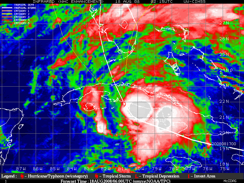
Follow the convection. It doesn't matter where the LLC is if it's not under the convection. The convection is Fay, not any exposed swirl (if there was one). The center will follow the convection, not the other way around.
If it stays sheared,
This maybe why some models had it going along the east coast and others the west coast
0 likes

Yeah the convective mass does seem to be pointing northwards and given the turn has happened sooner then forecasted that may wlel end up occuring.
GFS for waht its worth shows one heck of a set-up occuring...into S.Florida, then out into the Atlantic but high builds in again and eventuaslly shunts it back into the gulf!!!
GFS for waht its worth shows one heck of a set-up occuring...into S.Florida, then out into the Atlantic but high builds in again and eventuaslly shunts it back into the gulf!!!
0 likes
-
caneman
-
johngaltfla

- Category 5

- Posts: 2073
- Joined: Sun Jul 10, 2005 9:17 pm
- Location: Sarasota County, FL
- Contact:
Re: ATL: Tropical Storm Fay South of Cuba
I'll just relay what our local mets said; until this thing clears Cuba and they can get more data from recon for the models, there will be no final determination of intensity or the path for several more hours. This storm is frustrating their models also (TITAN, VORTEX, VIPIR, etc.) and explains the somewhat vague NHC discussion at 0500.
0 likes

I don't know if it is uncertainty but they can't deviate from the nhc forecast and say:" well it looks like this storm is actually going to follow the convection and take an easterly turn so we are out of the woods for the most part maybe some rain." Not with a hurricane watch up. They are hoping we can see where this is going. But this is what gets me. Warnings didn't get out to people that got hit by charley and some mets knew by looking at the direction of the rainbands that it would do what it did but that wasn't the nhc forecast so the wrong people got ready for the storm.
0 likes
Re:
You can see it start to fill in nicely in the WV http://www.ssd.noaa.gov/goes/east/gmex/loop-wv.html. I think it is retrograding a bit, but it certainly is not keeping up with Fay.caneman wrote:Anyone else notice the Nw side filling in. Wonder if the ULL is losing its grip now
0 likes
Re: ATL: Tropical Storm Fay South of Cuba
johngaltfla wrote:I'll just relay what our local mets said; until this thing clears Cuba and they can get more data from recon for the models, there will be no final determination of intensity or the path for several more hours. This storm is frustrating their models also (TITAN, VORTEX, VIPIR, etc.) and explains the somewhat vague NHC discussion at 0500.
Forget the models with fay. Use whats going on with the atmosphere in real time. you can see the changes taking place. Humans are more intelligent than computers anyways.
0 likes
Re: Re:
xironman wrote:You can see it start to fill in nicely in the WV http://www.ssd.noaa.gov/goes/east/gmex/loop-wv.html. I think it is retrograding a bit, but it certainly is not keeping up with Fay.caneman wrote:Anyone else notice the Nw side filling in. Wonder if the ULL is losing its grip now
all the main convection is clearly head east of fl. maybe the whole state will get away unless this can organize.
0 likes
-
Trader Ron

- S2K Supporter

- Posts: 928
- Joined: Tue Jul 22, 2003 7:25 pm
- Location: Naples,Fl
- Contact:
Re:
KWT wrote:Yeah the convective mass does seem to be pointing northwards and given the turn has happened sooner then forecasted that may wlel end up occuring.
GFS for waht its worth shows one heck of a set-up occuring...into S.Florida, then out into the Atlantic but high builds in again and eventuaslly shunts it back into the gulf!!!
The CMC stalls it off the coast of Ga, wouldn't that be strange. When was the last time that area was hit by a strong TS or Hurricane early 70's or before when did the Saratoga sink.
I just saw the ECMWF has it hitting that area.
Last edited by tailgater on Mon Aug 18, 2008 5:50 am, edited 1 time in total.
0 likes
-
tampastorm
- Category 1

- Posts: 434
- Joined: Thu Aug 12, 2004 9:22 pm
- Location: TAMPA
Re: ATL: Tropical Storm Fay South of Cuba
I know on the long view radar it looks North maybe NE, But on the short view radar you can clearly see some westerly component . Not sure what exactly what is going on, but I confident in saying it is not going northeast. Actually west side is expanding nicely. Just my thoughts anyway.
0 likes
Wouldn't be impossible tailgator,the models show the high pressure building strongly back into the east coast for a little while and as long Fay doesn't get totally picked up by the trough its exit route may well get blocked and that does raise the prospect of an uneasy motion near the gulf stream.
0 likes

The ULL is heading now more to the west and that may well be easing off the shear a little now and may be why the convection is starting to pull a little more on the western side where the LLC is. Also I don't think its got any real easterly motion yet but I do think there is a real good case for it to be moving only as little west of north, maybe NNW.
0 likes
-
O Town
- S2K Supporter
- Posts: 5205
- Age: 52
- Joined: Wed Sep 07, 2005 9:37 pm
- Location: Orlando, Florida 28°35'35"N 81°22'55"W
Wow, not was I as expecting to see this AM.
Shes seems to have taken a hard right and is feeling that trough alot more
than we all thought she would.
Looks like she has missed the cone entirely, and may miss the whole peninsula, or is that
just the convection thats blowing off and the center is still on track??
Shes seems to have taken a hard right and is feeling that trough alot more
than we all thought she would.
Looks like she has missed the cone entirely, and may miss the whole peninsula, or is that
just the convection thats blowing off and the center is still on track??
0 likes

Re:
It seems to just be the convection sheared off. Though in the environment she's in, it's possible it's a relocation.
O Town wrote:Wow, not was I as expecting to see this AM.
Shes seems to have taken a hard right and is feeling that trough alot more
than we all thought she would.
Looks like she has missed the cone entirely, and may miss the whole peninsula, or is that
just the convection thats blowing off and the center is still on track??
0 likes
Who is online
Users browsing this forum: No registered users and 10 guests