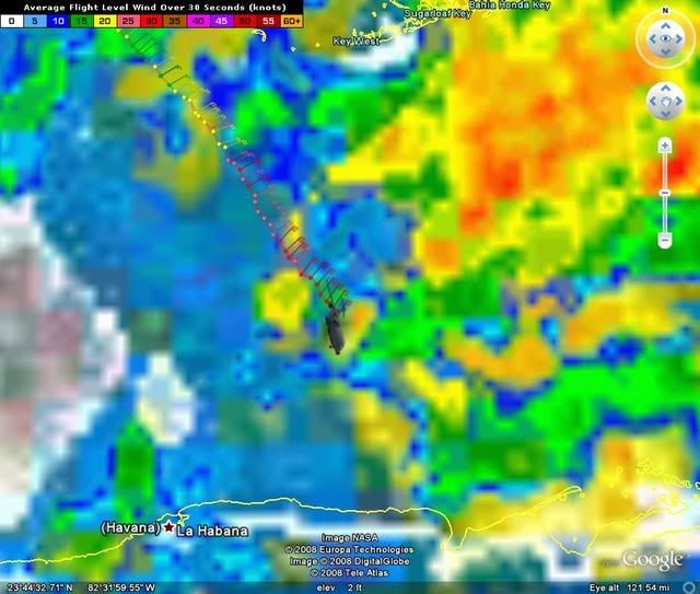
ATL: Tropical Depression Fay

Moderator: S2k Moderators

Message
Author
Matt-hurricanewatcher

Re:

#8061 Postby Matt-hurricanewatcher » Mon Aug 18, 2008 8:48 am

HURAKAN wrote:Image

Image


Looks like she is developing a loose eye. There is no question it is the best it has ever been right now. It has a innercore right now when it never before had a organized one. I expect that the convection to the east will die later today, and at that time convection will finally develop over the center. In which when it does that it will tighten up.
0 likes   

User avatar
Steve
S2K Supporter
S2K Supporter
Posts: 9628
Joined: Sat Apr 05, 2003 11:41 pm
Location: Gulf of Gavin Newsom

#8062 Postby Steve » Mon Aug 18, 2008 8:49 am

>>For those of you insisting that the models were off or the NHC was wrong please ride the snake

LMAO. However, since that track updates constantly from a new point each time, it's not like you can use that to say they were on track since they upgraded. Still a funny command for our fellow posters. :)

Steve
0 likes   

User avatar
Jevo
S2K Supporter
S2K Supporter
Posts: 1729
Age: 47
Joined: Tue Aug 03, 2004 8:45 pm
Location: The Flemish Cap
Contact:

Re: ATL: Tropical Storm Fay in Florida Straits

#8063 Postby Jevo » Mon Aug 18, 2008 8:49 am

This is a live streaming cam in Key West with sound

Enjoy

http://www.liveduvalstreet.com/
0 likes   

Air Force Met
Military Met
Military Met
Posts: 4372
Age: 56
Joined: Tue Jul 08, 2003 9:30 am
Location: Roan Mountain, TN

Re: Re:

#8064 Postby Air Force Met » Mon Aug 18, 2008 8:49 am

jinftl wrote:Has anyone let the NHC know that Fay is in bad shape and prob won't become a 'cane?

As of 8am they sang a different tune..


REPORTS FROM AN AIR FORCE RESERVE HURRICANE HUNTER AIRCRAFT INDICATE
THAT MAXIMUM SUSTAINED WINDS ARE NOW NEAR 60 MPH...100 KM/HR...
WITH HIGHER GUSTS. SOME STRENGTHENING IS EXPECTED AS THE CENTER OF
FAY MOVES OVER WATER. FAY IS FORECAST TO BE APPROACHING HURRICANE
STRENGTH IN THE FLORIDA KEYS AND TO BECOME A HURRICANE BEFORE IT
REACHES THE FLORIDA PENINSULA.


You really need to learn a little more about the politics of tropical forecasting. :wink:
0 likes   

cpdaman
Category 5
Category 5
Posts: 3131
Joined: Sat Jun 10, 2006 11:44 am
Location: SPB county (gulf stream)

Re: ATL: Tropical Storm Fay in Florida Straits

#8065 Postby cpdaman » Mon Aug 18, 2008 8:50 am

wow great shots guys, also recon is about 20 min away from giving us a confired LLC so , lets us see

also sanibel what is your appox latitude and longitude of your resisdence , if you don't mind


as far as fay looking good, well perhaps if her center is more toward the eastern side of that larger spinning vortex that is visible on radar as of late, but i will wait for recon to see .

also steve i thought the same thing
Last edited by cpdaman on Mon Aug 18, 2008 8:51 am, edited 1 time in total.
0 likes   

tolakram
Admin
Admin
Posts: 20165
Age: 62
Joined: Sun Aug 27, 2006 8:23 pm
Location: Florence, KY (name is Mark)

Re: ATL: Tropical Storm Fay in Florida Straits

#8066 Postby tolakram » Mon Aug 18, 2008 8:50 am

Could it also be said, based on visible, that the MLC seems to be stacked on top of the LLC? I see spin on the cloud tops above or near the LLC which is hidden below these clouds.
Last edited by tolakram on Mon Aug 18, 2008 8:51 am, edited 1 time in total.
0 likes   

mattpetre
Category 2
Category 2
Posts: 510
Age: 53
Joined: Mon Sep 19, 2005 3:20 pm
Location: Missouri City,TX & Galleria
Contact:

Re: ATL: Tropical Storm Fay in Florida Straits

#8067 Postby mattpetre » Mon Aug 18, 2008 8:50 am

If we are lucky, maye 2008 will be a year of many storms but not many that do catastrophic damage. I'm really happy to see that I was wrong thinking the trough in the SE wouldn't pick this up in time. Yea! to being wrong. I am not discounting impact to S. FL, but this could have been much worse if it had time to traverse the entire GOM.
0 likes   

capepoint
Category 1
Category 1
Posts: 415
Joined: Sat Jul 19, 2008 7:13 pm
Location: Beaufort, NC

#8068 Postby capepoint » Mon Aug 18, 2008 8:51 am

hurrikan, does it look to you like some of that NE stuff MIGHT break away? I think thats what I'm seeing but not sure. Compare it's movement with that of circ center area. Not enough coffee yet this morning.......
0 likes   

User avatar
WhirlWind
Tropical Storm
Tropical Storm
Posts: 104
Age: 66
Joined: Sat Oct 12, 2002 9:04 pm
Location: Lehigh Acres, Florida
Contact:

#8069 Postby WhirlWind » Mon Aug 18, 2008 8:52 am

Sanibel - We also noticed the moon last evening, and the air condition was weird to say the least. It was so still and quite. This morning, not to much has changed and my dog is acting weird as all get out, not to many birds are out and about here either. Not that I am sure all that means much. Guess it is a wait and see situation for now.
Stay Safe All
WhirlWind
0 likes   

User avatar
Vortex
S2K Supporter
S2K Supporter
Posts: 4644
Age: 53
Joined: Fri Aug 01, 2003 9:34 pm
Location: Hilton Head, SC

Re: ATL: Tropical Storm Fay in Florida Straits

#8070 Postby Vortex » Mon Aug 18, 2008 8:52 am

6Z UKMET moves Fay north while strengthening with landfall across the middle keys and south FL. Then rides the east coast of FL.

http://moe.met.fsu.edu/cgi-bin/ukmtc2.c ... =Animation
0 likes   

User avatar
Category 5
Category 5
Category 5
Posts: 10074
Age: 35
Joined: Sun Feb 11, 2007 10:00 pm
Location: New Brunswick, NJ
Contact:

Re: ATL: Tropical Storm Fay in Florida Straits

#8071 Postby Category 5 » Mon Aug 18, 2008 8:52 am

mattpetre wrote:If we are lucky, maye 2008 will be a year of many storms but not many that do catastrophic damage. I'm really happy to see that I was wrong thinking the trough in the SE wouldn't pick this up in time. Yea! to being wrong. I am not discounting impact to S. FL, but this could have been much worse if it had time to traverse the entire GOM.


Lets not count our chickens before they hatch, this still has some time.
0 likes   

User avatar
artist
Category 5
Category 5
Posts: 9792
Joined: Mon Jun 06, 2005 3:26 pm
Location: West Palm

Re: Re:

#8072 Postby artist » Mon Aug 18, 2008 8:54 am

StJoe wrote:
gatorcane wrote:well this does appear to be panning out as a Southern FL event has I suspected from 5 days ago when we first started tracking Fay when she was 92L...lots of heavy squall are coming ashore SE FL this morning....and the winds are increasing within the heavier squalls.

as tracks shift East Fay is getting closer to what CLIMO suggested all along when Fay was in her seminal stages over the big island of Hispaniola --- and CLIMO may win out yet again.

Latest image:
http://metofis.rsmas.miami.edu/~dortt/s ... latest.gif


Where are you in Wellington GatorCane? I know I've asked you before, but you don't reply?


hey STJoe I know you didn't ask me bu t the Acreage here. How prepared are you getting? Shutters ? Did you see our warning states if it goes east of the lake?
0 likes   

Sanibel
Category 5
Category 5
Posts: 10385
Joined: Mon Aug 30, 2004 11:06 pm
Location: Offshore SW Florida

Re: ATL: Tropical Storm Fay in Florida Straits

#8073 Postby Sanibel » Mon Aug 18, 2008 8:54 am

LMAO. However, since that track updates constantly from a new point each time, it's not like you can use that to say they were on track since they upgraded. Still a funny command for our fellow posters.


Ah, Steve. That track is unusually consistent compared to other NHC tracks. Though I suspect we'll see it go more east again.
0 likes   

PurdueWx80
Professional-Met
Professional-Met
Posts: 2720
Joined: Fri Aug 13, 2004 8:33 pm
Location: Madison, WI
Contact:

Re: ATL: Tropical Storm Fay in Florida Straits

#8074 Postby PurdueWx80 » Mon Aug 18, 2008 8:55 am

i'm not so sure that fay is in such bad shape this morning. early visible shots show a clear expansion of outflow in the western portion of the storm, and convection seems to be rapidly expanding into the NW quad now.

vis loop
key west loop
0 likes   

Ed Mahmoud

Re: ATL: Tropical Storm Fay in Florida Straits

#8075 Postby Ed Mahmoud » Mon Aug 18, 2008 8:56 am

I think I might see more than one area of rotation in the radar imagery.
0 likes   

User avatar
HURAKAN
Professional-Met
Professional-Met
Posts: 46086
Age: 38
Joined: Thu May 20, 2004 4:34 pm
Location: Key West, FL
Contact:

#8076 Postby HURAKAN » Mon Aug 18, 2008 8:57 am

Image

RECON getting closer to the center.
0 likes   

User avatar
NDG
S2K Supporter
S2K Supporter
Posts: 15507
Joined: Sun Jul 09, 2006 10:14 pm
Location: Orlando, FL

Re: ATL: Tropical Storm Fay in Florida Straits

#8077 Postby NDG » Mon Aug 18, 2008 8:57 am

Vortex wrote:6Z UKMET moves Fay north while strengthening with landfall across the middle keys and south FL. Then rides the east coast of FL.

http://moe.met.fsu.edu/cgi-bin/ukmtc2.c ... =Animation


Bad run, UKMET has her moving straight north after moving into Cuba and after exiting Cuba, when we know that Fay continues on a NNW heading ever since it made landfall in Cuba
0 likes   

tolakram
Admin
Admin
Posts: 20165
Age: 62
Joined: Sun Aug 27, 2006 8:23 pm
Location: Florence, KY (name is Mark)

Re: ATL: Tropical Storm Fay in Florida Straits

#8078 Postby tolakram » Mon Aug 18, 2008 8:58 am

Sanibel wrote:
LMAO. However, since that track updates constantly from a new point each time, it's not like you can use that to say they were on track since they upgraded. Still a funny command for our fellow posters.


Ah, Steve. That track is unusually consistent compared to other NHC tracks. Though I suspect we'll see it go more east again.


I think you miss my point. Here is a single image of the track created once recon got a solid fix over the ocean. Intensity was wrong, it almost always is, but pretty darn good forecast track.

Image
0 likes   

Sanibel
Category 5
Category 5
Posts: 10385
Joined: Mon Aug 30, 2004 11:06 pm
Location: Offshore SW Florida

Re: ATL: Tropical Storm Fay in Florida Straits

#8079 Postby Sanibel » Mon Aug 18, 2008 8:58 am

sanibel what is your appox latitude and longitude of your resisdence , if you don't mind


26.4N-82.1W
0 likes   

cpdaman
Category 5
Category 5
Posts: 3131
Joined: Sat Jun 10, 2006 11:44 am
Location: SPB county (gulf stream)

Re: ATL: Tropical Storm Fay in Florida Straits

#8080 Postby cpdaman » Mon Aug 18, 2008 9:00 am

PurdueWx80 wrote:i'm not so sure that fay is in such bad shape this morning. early visible shots show a clear expansion of outflow in the western portion of the storm, and convection seems to be rapidly expanding into the NW quad now.

vis loop
key west loop


well we know that should the center get a lil bit further away from the ull ,(wether it is ull retrograding or LLC getting pulled under deeper convection eastward) that all of a sudden conditions could become favorable..........like they seem to get right before southern coastal cuban landfall lastnite...........
0 likes   


Return to “2008”

Who is online

Users browsing this forum: No registered users and 22 guests