ATL: Tropical Depression Fay

Moderator: S2k Moderators

Message
Author
User avatar
Canelaw99
S2K Supporter
S2K Supporter
Posts: 2128
Age: 49
Joined: Tue Aug 31, 2004 8:27 am
Location: Homestead, FL

Re:

#8821 Postby Canelaw99 » Mon Aug 18, 2008 4:46 pm

Evil Jeremy wrote:Ok, now Fay is really freaking me out. Where is it headed?

http://radar.weather.gov/radar.php?prod ... x&loop=yes


LOL - could you imagine a storm that decided to track basically up US1 through the Keys? :eek:
0 likes   

capepoint
Category 1
Category 1
Posts: 415
Joined: Sat Jul 19, 2008 7:13 pm
Location: Beaufort, NC

Re:

#8822 Postby capepoint » Mon Aug 18, 2008 4:46 pm

Evil Jeremy wrote:Ok, now Fay is really freaking me out. Where is it headed?

http://radar.weather.gov/radar.php?prod ... x&loop=yes


I'll let you know for sure next week. :cheesy:
0 likes   

User avatar
Evil Jeremy
S2K Supporter
S2K Supporter
Posts: 5463
Age: 32
Joined: Mon Apr 10, 2006 2:10 pm
Location: Los Angeles, CA

#8823 Postby Evil Jeremy » Mon Aug 18, 2008 4:46 pm

New Tornado warning. This time for SE Broward County.
0 likes   

User avatar
fci
S2K Supporter
S2K Supporter
Posts: 3324
Joined: Tue Sep 14, 2004 10:29 am
Location: Lake Worth, FL

Re:

#8824 Postby fci » Mon Aug 18, 2008 4:46 pm

Canelaw99 wrote:Per Ed Rappaport at NHC:
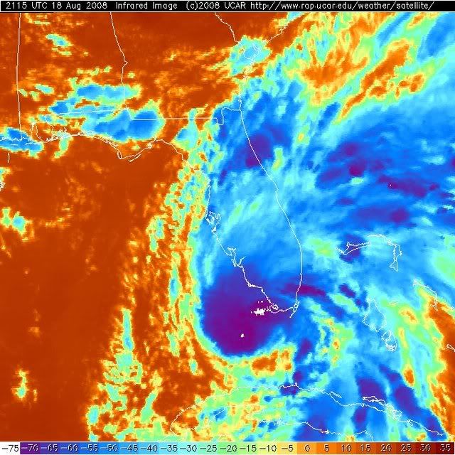
They've noticed the indications of rapid motion/tornadic activity. Worst of that has moved N of the lower Keys. We'll see more over the peninsula tonight and in the morning. I think what we're seeing (the easterly jog/move) is a reorganization of the center and strengthening. The northward heading is still the best one to follow, and that would bring the center over the coast of SW FL, and the conditions in SE FL should begin to improve tonight and into the morning.


Conditions improving into the morning works perfectly with closing the schools in Palm Beach County!
0 likes   

Myersgirl
Tropical Storm
Tropical Storm
Posts: 216
Joined: Fri Jul 23, 2004 7:32 pm
Location: Fort Myers
Contact:

Re:

#8825 Postby Myersgirl » Mon Aug 18, 2008 4:47 pm

HURAKAN wrote:Image

WOULD YOU PLEASE SHOW ME THE APPROXIMATE CENTER
0 likes   

RL3AO
Moderator-Pro Met
Moderator-Pro Met
Posts: 16308
Joined: Thu Jun 14, 2007 10:03 pm
Location: NC

Re: Re:

#8826 Postby RL3AO » Mon Aug 18, 2008 4:48 pm

Myersgirl wrote:WOULD YOU PLEASE SHOW ME THE APPROXIMATE CENTER


Right over Key West.
0 likes   

lebron23
Category 1
Category 1
Posts: 389
Age: 32
Joined: Sat May 24, 2008 11:58 am
Contact:

Re: ATL: Tropical Storm Fay South of Fort Myers

#8827 Postby lebron23 » Mon Aug 18, 2008 4:49 pm

This is slowly looking better!
0 likes   

NEXRAD
Category 1
Category 1
Posts: 370
Joined: Fri Jul 22, 2005 12:05 am
Location: South Florida

Re: ATL: Tropical Storm Fay South of Fort Myers

#8828 Postby NEXRAD » Mon Aug 18, 2008 4:50 pm

tailgater wrote:Definite jog eastward but I will go with NHC and say it will continue Northward.


If you follow the center of the swirl rather than the convective bands the motion is nearly stationary. It appears that the bands around the center may be tightening some, hence the apparent movement.

- Jay
0 likes   

User avatar
artist
Category 5
Category 5
Posts: 9792
Joined: Mon Jun 06, 2005 3:26 pm
Location: West Palm

#8829 Postby artist » Mon Aug 18, 2008 4:51 pm

we have dozens upon dozens of lizards on our back patio and there is not a one to be seen today- not one. I have even been bringing in my orchids and not one to be found.
Dogs seem nervous still, barking at things not to be seen! lol :cheesy:
0 likes   

User avatar
Blown Away
S2K Supporter
S2K Supporter
Posts: 10252
Joined: Wed May 26, 2004 6:17 am

Re: ATL: Tropical Storm Fay South of FT Myers

#8830 Postby Blown Away » Mon Aug 18, 2008 4:52 pm

Image


Ok, 50 minutes ago the NHC says Fay is moving NNW at 12mph, the radar shows an E drift, what's up? Local Met thinks we may have a Cat 1 cane at 8pm, based on the pressure drop. Can somebody explain the radar??
0 likes   

User avatar
Bgator
Category 2
Category 2
Posts: 649
Joined: Mon Sep 05, 2005 12:29 pm
Location: Orlando, FL

Re: ATL: Tropical Storm Fay South of Fort Myers

#8831 Postby Bgator » Mon Aug 18, 2008 4:53 pm

Jay, can you explain again why the winds have not picked up in the metro areas? Thanks.
0 likes   

User avatar
johngaltfla
Category 5
Category 5
Posts: 2072
Joined: Sun Jul 10, 2005 9:17 pm
Location: Sarasota County, FL
Contact:

Re: ATL: Tropical Storm Fay South of Fort Myers

#8832 Postby johngaltfla » Mon Aug 18, 2008 4:54 pm

What is even weirder is that everyone on the local channels has projected that it will have a southern track. Then there is the one guy who follows other models that says don't focus on the models, watch the cone.

This storm deserves Duval St. It's drunk and I think I'll join it.

If it continues to wobble or stall I say all bets are off. She's got that Rosie O'Donnell look to her and she is about to get really, really mean.

I swear I haven't seen anything like this since Elena.
0 likes   

User avatar
tailgater
S2K Supporter
S2K Supporter
Posts: 3339
Joined: Sun Jul 11, 2004 9:13 pm
Location: St. Amant La.

Re: ATL: Tropical Storm Fay South of Fort Myers

#8833 Postby tailgater » Mon Aug 18, 2008 4:54 pm

NEXRAD wrote:
tailgater wrote:Definite jog eastward but I will go with NHC and say it will continue Northward.


If you follow the center of the swirl rather than the convective bands the motion is nearly stationary. It appears that the bands around the center may be tightening some, hence the apparent movement.

- Jay

Yes the center seems to be spitting out vortex after vortex 1 a little east of KW and 1 A little north with the main? just a tad west of KW
0 likes   

User avatar
Canelaw99
S2K Supporter
S2K Supporter
Posts: 2128
Age: 49
Joined: Tue Aug 31, 2004 8:27 am
Location: Homestead, FL

Re: ATL: Tropical Storm Fay South of Fort Myers

#8834 Postby Canelaw99 » Mon Aug 18, 2008 4:55 pm

LOL yep - she's slurpin' up every drop to drink over Key West I guess...
0 likes   

NEXRAD
Category 1
Category 1
Posts: 370
Joined: Fri Jul 22, 2005 12:05 am
Location: South Florida

Re: ATL: Tropical Storm Fay South of Fort Myers

#8835 Postby NEXRAD » Mon Aug 18, 2008 4:55 pm

Tornado Threat Increasing

Per the 21Z SPC mesoanalysis, helicity values above 150m2/s2 have developed across Southeast Florida, southeast of a line from about Naples to Lake Okeechobbee to Stuart. Maximum helicities above 300m2/s2 are present across Miami-Dade and Broward counties and are progressing into Palm Beach County. The RUC/2 mesoanalysis agrees well with the Florida ADAS mesonet analysis.

There will be a continued risk for rotating storm cells across all of South Florida. The threat for storm cells capable of producing tornadoes will gradually spread north into portions of South Central Florida later tonight.

- Jay
0 likes   

gtsmith
Tropical Storm
Tropical Storm
Posts: 181
Joined: Fri Sep 24, 2004 7:05 am
Location: West Palm Beach, FL

Re: ATL: Tropical Storm Fay South of Fort Myers

#8836 Postby gtsmith » Mon Aug 18, 2008 4:55 pm

dolebot_Broward_NW wrote:The First bow echo I drove through:

Image


And the next coming ashore:

Image

CAREFUL in Boca/North Broward!


After those two...should be a quiet spell for a while in SE florida as we catch the dry air entrainment...i see a big gap on radar
0 likes   

User avatar
johngaltfla
Category 5
Category 5
Posts: 2072
Joined: Sun Jul 10, 2005 9:17 pm
Location: Sarasota County, FL
Contact:

Re: ATL: Tropical Storm Fay South of FT Myers

#8837 Postby johngaltfla » Mon Aug 18, 2008 4:56 pm

Blown_away wrote:
Image


Ok, 50 minutes ago the NHC says Fay is moving NNW at 12mph, the radar shows an E drift, what's up? Local Met thinks we may have a Cat 1 cane at 8pm, based on the pressure drop. Can somebody explain the radar??


It was. I think this storm is nuts. Absolutely nuts. I can not find any good upper air data here or elsewhere to explain this stall. If she stalls for 12-24 hours I say everyone can set their hair on fire and get excited again. This storm is not making any sense at all.

It is Elena on steroids.

All over again. :eek:
0 likes   

lebron23
Category 1
Category 1
Posts: 389
Age: 32
Joined: Sat May 24, 2008 11:58 am
Contact:

Re: ATL: Tropical Storm Fay South of Fort Myers

#8838 Postby lebron23 » Mon Aug 18, 2008 4:57 pm

Fay looks like it is trying to slow down just a tad......
0 likes   

Shockwave
Tropical Storm
Tropical Storm
Posts: 167
Joined: Fri Jul 25, 2008 7:33 am
Location: Lafayette, TN
Contact:

Re: ATL: Tropical Storm Fay South of Fort Myers

#8839 Postby Shockwave » Mon Aug 18, 2008 4:57 pm

johngaltfla wrote:What is even weirder is that everyone on the local channels has projected that it will have a southern track. Then there is the one guy who follows other models that says don't focus on the models, watch the cone.

This storm deserves Duval St. It's drunk and I think I'll join it.

If it continues to wobble or stall I say all bets are off. She's got that Rosie O'Donnell look to her and she is about to get really, really mean.

I swear I haven't seen anything like this since Elena.


I don't remember Elena or many hurricanes in that matter, but I can safely say I've never seen a storm do as much ackward stuff that Fay has done. Her sitting there and spinning has me concerned. That mb pressure drop down to 998 is what shocked me most, but I'd like to see what the next reading is and how much lower it has gone.
0 likes   

User avatar
Weatherboy1
Category 5
Category 5
Posts: 1190
Age: 50
Joined: Mon Jul 05, 2004 1:50 pm
Location: Jupiter/Sarasota, FL

#8840 Postby Weatherboy1 » Mon Aug 18, 2008 4:58 pm

It looks to me like Fay is getting very close to hurricane strength, or will be there soon especially now that pressures are down a bit and convection appears to be wrapping around the south side too.
0 likes   


Return to “2008”

Who is online

Users browsing this forum: No registered users and 39 guests