000
FZNT23 KNHC 201446
OFFNT3
OFFSHORE WATERS FORECAST FOR THE SOUTHWEST AND TROPICAL NORTH
ATLANTIC AND CARIBBEAN SEA
NWS TPC/NATIONAL HURRICANE CENTER MIAMI FL
1130 AM EDT WED AUG 20 2008
OFFSHORE WATERS FORECAST FOR THE CARIBBEAN SEA AND
TROPICAL N ATLC FROM 07N TO 22N BETWEEN 55W AND 65W
SEAS GIVEN AS SIGNIFICANT WAVE HEIGHT...WHICH IS THE AVERAGE
HEIGHT OF THE HIGHEST 1/3 OF THE WAVES. INDIVIDUAL WAVES MAY
BE MORE THAN TWICE THE SIGNIFICANT WAVE HEIGHT.
AMZ089-202130-
SYNOPSIS FOR CARIBBEAN SEA AND TROPICAL N ATLC FROM 07N TO 22N
BETWEEN 55W AND 65W
1130 AM EDT WED AUG 20 2008
.SYNOPSIS...
ANOTHER TROPICAL WAVE WILL MOVE TO 55W FRI AND INTO THE E
CARIBBEAN SAT AND SUN. LOW E OF THE AREA SHOULD MOVE INTO THE E
CARIBBEAN SAT AND INTO THE CENTRAL CARIBBEAN SUN.
ATL GUSTAV: Tropical Depression - Discussion
Moderator: S2k Moderators
-
Gustywind

- Category 5

- Posts: 12334
- Joined: Mon Sep 03, 2007 7:29 am
- Location: Baie-Mahault, GUADELOUPE
Dr. Jeff Masters' WunderBlog
http://www.wunderground.com/blog/JeffMa ... amp=200808
Last Updated: 16:20 GMT le 20 août 2008 — Last Comment: 17:07 GMT le 20 août 2008
Elsewhere in the Tropics
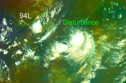
Invest 94L has limited thunderstorm activity this morning. Dry air, and a future full of wind shear gives 94L a smaller and smaller chance of developing as the days pass.
http://www.wunderground.com/blog/JeffMa ... amp=200808
Last Updated: 16:20 GMT le 20 août 2008 — Last Comment: 17:07 GMT le 20 août 2008
Elsewhere in the Tropics
Invest 94L has limited thunderstorm activity this morning. Dry air, and a future full of wind shear gives 94L a smaller and smaller chance of developing as the days pass.
0 likes
-
Dean4Storms
- S2K Supporter

- Posts: 6358
- Age: 63
- Joined: Sun Aug 31, 2003 1:01 pm
- Location: Miramar Bch. FL
-
cycloneye

- Admin

- Posts: 149282
- Age: 69
- Joined: Thu Oct 10, 2002 10:54 am
- Location: San Juan, Puerto Rico
Re: ATL: Invest 94L in Central Atlantic
ABNT20 KNHC 201743
TWOAT
TROPICAL WEATHER OUTLOOK
NWS TPC/NATIONAL HURRICANE CENTER MIAMI FL
200 PM EDT WED AUG 20 2008
FOR THE NORTH ATLANTIC...CARIBBEAN SEA AND THE GULF OF MEXICO...
THE NATIONAL HURRICANE CENTER IS ISSUING ADVISORIES ON TROPICAL
STORM FAY...CENTERED ALONG THE EAST COAST OF FLORIDA NEAR CAPE
CANAVERAL.
 AN AREA OF LOW PRESSURE LOCATED ABOUT 1300 MILES EAST OF THE
WINDWARD ISLANDS HAS CHANGED LITTLE DURING THE DAY. ANY DEVELOPMENT
OF THIS SYSTEM IS EXPECTED TO BE SLOW TO OCCUR DURING THE NEXT
COUPLE OF DAYS AS IT MOVES WESTWARD AT 10 TO 15 MPH.
ELSEWHERE...TROPICAL CYCLONE FORMATION IS NOT EXPECTED DURING THE
NEXT 48 HOURS.
$$
FORECASTER BLAKE
TWOAT
TROPICAL WEATHER OUTLOOK
NWS TPC/NATIONAL HURRICANE CENTER MIAMI FL
200 PM EDT WED AUG 20 2008
FOR THE NORTH ATLANTIC...CARIBBEAN SEA AND THE GULF OF MEXICO...
THE NATIONAL HURRICANE CENTER IS ISSUING ADVISORIES ON TROPICAL
STORM FAY...CENTERED ALONG THE EAST COAST OF FLORIDA NEAR CAPE
CANAVERAL.
WINDWARD ISLANDS HAS CHANGED LITTLE DURING THE DAY. ANY DEVELOPMENT
OF THIS SYSTEM IS EXPECTED TO BE SLOW TO OCCUR DURING THE NEXT
COUPLE OF DAYS AS IT MOVES WESTWARD AT 10 TO 15 MPH.
ELSEWHERE...TROPICAL CYCLONE FORMATION IS NOT EXPECTED DURING THE
NEXT 48 HOURS.
$$
FORECASTER BLAKE
0 likes


-
cheezyWXguy

- Category 5
- Posts: 6281
- Joined: Mon Feb 13, 2006 12:29 am
- Location: Dallas, TX
Re: Re:
HURAKAN wrote:Scorpion wrote:I agree Sanibel. It's already been 4 years since we've had a genuine CV storm. I wonder when the cap will come off.
Bertha ???
Dean??
0 likes

Convection developing a little better again...
the thing to note is its heading towards the Caribbean, the poor conditions presently won't be there by the time this gets to 60W and it'll hit the warm waters of the Caribbean, wouldn't be surprised if this is another Dolly type system actually!
the thing to note is its heading towards the Caribbean, the poor conditions presently won't be there by the time this gets to 60W and it'll hit the warm waters of the Caribbean, wouldn't be surprised if this is another Dolly type system actually!
0 likes
-
Gustywind
- Category 5
- Posts: 12334
- Joined: Mon Sep 03, 2007 7:29 am
- Location: Baie-Mahault, GUADELOUPE
AXNT20 KNHC 201801
TWDAT
TROPICAL WEATHER DISCUSSION...
NWS TPC/NATIONAL HURRICANE CENTER MIAMI FL
205 PM EDT WED AUG 20 2008
TROPICAL WEATHER DISCUSSION FOR NORTH AMERICA...CENTRAL
AMERICA...GULF OF MEXICO...CARIBBEAN SEA...NORTHERN SECTIONS
OF SOUTH AMERICA...AND ATLANTIC OCEAN TO THE AFRICAN COAST
FROM THE EQUATOR TO 32N. THE FOLLOWING INFORMATION IS BASED
ON SATELLITE IMAGERY...METEOROLOGICAL ANALYSIS...WEATHER
OBSERVATIONS...AND RADAR.
BASED ON 1200 UTC SURFACE ANALYSIS AND SATELLITE IMAGERY THROUGH
1715 UTC.
0 likes
-
Gustywind
- Category 5
- Posts: 12334
- Joined: Mon Sep 03, 2007 7:29 am
- Location: Baie-Mahault, GUADELOUPE
Re:
KWT wrote:Knowing this season this system will wait till about 60W then tease us until about 70W and only then finally do something
Never says that, in this part of the season anything can happen, you tkink it's weak and just after it's strong, just wait and don't let our guard down by the appareant calm before the... storm ( hope nothing from that too
0 likes
-
cycloneye
- Admin
- Posts: 149282
- Age: 69
- Joined: Thu Oct 10, 2002 10:54 am
- Location: San Juan, Puerto Rico
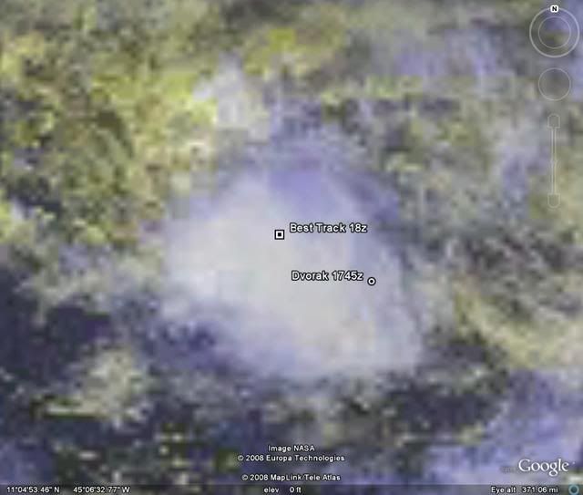
Re: ATL: Invest 94L in Central Atlantic
They keep tracking it at the ATCF Best Track,in this case the 18:00 UTC Update.Low with pressure down to 1007 mbs:
AL, 94, 2008082018, , BEST, 0, 125N, 435W, 25, 1007, LO, 34, NEQ, 0, 0, 0, 0,
ftp://ftp.tpc.ncep.noaa.gov/atcf/tcweb/
AL, 94, 2008082018, , BEST, 0, 125N, 435W, 25, 1007, LO, 34, NEQ, 0, 0, 0, 0,
ftp://ftp.tpc.ncep.noaa.gov/atcf/tcweb/
0 likes
Yeah its still there and convection is still firing as well granted its not in a very faovrable location for strengthening right now, I find it hard to believe that the ULL will follow this till 70W however so think something will come from this probably as it gets towards the Caribbean, not buying those northerly tracks with a powerful high to the north of it right now.
0 likes
-
latemodel25

- Category 1

- Posts: 454
- Joined: Sat Sep 04, 2004 4:15 am
- Location: parrish fl
- Contact:
-
SouthFloridawx

- S2K Supporter
- Posts: 8346
- Age: 47
- Joined: Tue Jul 26, 2005 1:16 am
- Location: Sarasota, FL
- Contact:
Re:
Looks like help is on the way for 94L. I saw yesterday when UKMET initialized 94L, but farther east, then moved it to the north and then back to the west. Perhaps this was with some interaction between the two systems.
If you take a look at this loop from the 12Z yesterday you can see what I'm talking about.
http://moe.met.fsu.edu/cgi-bin/ukmtc2.cgi?time=2008081912&field=Sea+Level+Pressure&hour=Animation
If you take a look at this loop from the 12Z yesterday you can see what I'm talking about.
http://moe.met.fsu.edu/cgi-bin/ukmtc2.cgi?time=2008081912&field=Sea+Level+Pressure&hour=Animation
HURAKAN wrote:
0 likes
Who is online
Users browsing this forum: No registered users and 188 guests