
[quote="Sabanic"][quote="N2Storms"]Fay's max sustained winds have decreased to 40 mph...she still looks pretty decent but it appears as though she is finally and ever so gradually beginning to weaken...[/quote]
DID THE NHC PUT THAT INFO OUT?
STILL BELIEVE WHEN SHE GETS OFF OF PENINSULA SHE WILL GET WHATEVER SHE HAS LOST BACK[/quote]
No, that info is not an official product of the NHC...it is from our local TV Station WJHG TV and Chief Meterologist Jason Kelly
Posted: 2:44 PM Aug 22, 2008
Last Updated: 2:44 PM Aug 22, 2008
--------------------------------------------------------------------------------
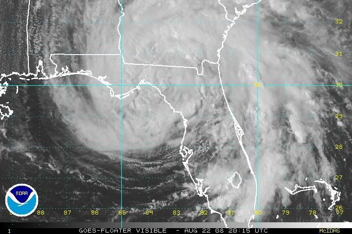
A | A | A A tropical storm warning is posted for all of Northwest Florida from the Big Bend Area west to Destin. Tropical Storm Fay’s outer bands have started to approach the area as the storm centers on Apalachee Bay west of Cedar Key.
Its moving west at only 4 miles an hour, so it’s expected to be around for a couple more days. Highest sustained winds are 40 miles per hour with gusts to 55 MPH.
ATL: Tropical Depression Fay
Moderator: S2k Moderators
-
MetsIslesNoles

- S2K Supporter

- Posts: 64
- Joined: Thu Jul 07, 2005 10:42 pm
- Location: Tallahassee, FL
Re: ATL: Tropical Storm Fay over northern Florida Penninsula
Yeah "only a tropical storm" meanwhile, here in Tally a friend just had a tree fall on the house... and we've hardly felt the storm... a couple of heavy rains and a few minor gusts.
And to think I have people that laugh at me that say I'd bail out of Tally if I knew 100mph sustained would be in town. The trees here would go flying everywhere, and the houses are built like match sticks... not the concrete block of south fla or the poured concrete.
I just hope it never happens.
And to think I have people that laugh at me that say I'd bail out of Tally if I knew 100mph sustained would be in town. The trees here would go flying everywhere, and the houses are built like match sticks... not the concrete block of south fla or the poured concrete.
I just hope it never happens.
0 likes


-
jlauderdal
- S2K Supporter
- Posts: 7240
- Joined: Wed May 19, 2004 5:46 am
- Location: NE Fort Lauderdale
- Contact:
Re: ATL: Tropical Storm Fay over northern Florida Penninsula
SouthFLTropics wrote:jlauderdal wrote:Enzo Aquarius wrote:Tornado warnings are gone for the Jacksonville area. The band in the area has moved west and appears to have weakened. A second larger band in the Atlantic, however, appears to be moving in. Miami area is getting hammered by some of the south outer bands of Fay, and boy are they getting hit hard.
time for a nap before that next line comes through
jlauderdale...Do you have a link for that radar site?


i use grlevel 2 and grlevel 3 so you have to purchase it but believe me its the way to go and worth the investment
http://www.grlevelx.com/
PM me if you have any questions, we dont want any board warnings issued for being off topic, they have evaluation versions of both packages
0 likes
-
jlauderdal
- S2K Supporter
- Posts: 7240
- Joined: Wed May 19, 2004 5:46 am
- Location: NE Fort Lauderdale
- Contact:
Re: Re:
HURAKAN wrote:HURAKAN wrote:Very heavy rainstorm affecting my area at the moment. Picture and video in a few minutes.
So far today: 1 inch of rain
Thanks to Fay: 7.07 inches of rain
broward residents are glad our friends to the south are getting in on the action
0 likes
-
Ed Mahmoud
Re: ATL: Tropical Storm Fay over northern Florida Penninsula
I posted some of this on the 94L model thread.
Fay may be the 'gift' that keeps giving to Florida.
The GFDL finally does not dissipate 94L, but hits Jamaica with a Cat 3 West-ward moving storm. Checking GFDLs outer grid 500 mb heights on my AccuWx PPV web site, I see that ridging should steer the storm almost due West, Yucatan and then second Mexican landfall. Except, the 500 mb weakness left by Fay wanders West a bit, and then a passing trough in the Westerlies dips down and instead of lifting ex-Fay out, forms a very deep and slow moving trough with its base in SW Louisiana, with a slight positive tilt. The trough seems to try to slowly lift out, and potential Gustav is still about 10º East of the latitude of the trough at 126 hours, but 94L on the GFDL seems to be moving West faster than the trough containing ex-Fay as its anchor seems to be lifting out.
So, speculation, of course, absolutely not a forecast, but it is possible that even after Fay leaves Florida, it may recurve the next system towards Florida or the Northern Gulf.
0 likes


Re: ATL: Tropical Storm Fay over northern Florida Penninsula
here are some pictures of the damage and rain fall amounts Fay brought us
the day before, that lifeguard chair was 3 feet from the shore and this is a decent sized lake

camp boat was 3/4 submerged and the water up the level of the dock


fallen tree on a power line, luckily it just missed our bathhouse

different angle..and not rotated LOL

the day before, that lifeguard chair was 3 feet from the shore and this is a decent sized lake
camp boat was 3/4 submerged and the water up the level of the dock
fallen tree on a power line, luckily it just missed our bathhouse
different angle..and not rotated LOL
0 likes


-
Ed1
Re: ATL: Tropical Storm Fay over northern Florida Penninsula
Rain Totals
http://www.srh.noaa.gov/productview.php?pil=PNSMLB&version=1&max=10
PNSMLB
PUBLIC INFORMATION STATEMENT...UPDATE 3
NATIONAL WEATHER SERVICE MELBOURNE FL
215 PM EDT FRI AUG 22 2008
...TROPICAL STORM FAY PRODUCES RECORD FLOODING ACROSS PORTIONS OF
EAST CENTRAL FLORIDA...
BELOW ARE SOME SELECTED PRELIMINARY RAINFALL TOTALS FROM THE RECORD
RAINFALL EVENT ASSOCIATED WITH TROPICAL STORM FAY. THE STORM TOTAL
VALUES ARE MULTI-DAY ACCUMULATIONS...BEGINNING MONDAY AUGUST 18 WHEN
THE TROPICAL STORM WAS OVER THE FLORIDA STRAITS AND OUTER RAINBANDS
BEGAN TO ROTATE ONSHORE THE SOUTHERN PENINSULA. AT THIS TIME...
RAINBANDS CONTINUE TO AFFECT NORTHERN PORTIONS OF THE NWS MELBOURNE
FORECAST AREA AND ADDITIONAL HEAVY RAIN IS EXPECTED IN MANY AREAS
TODAY. THE INFORMATION BELOW WILL BE UPDATED AS ADDITIONAL DATA IS
COMPILED. A PRELIMINARY POST TROPICAL CYCLONE REPORT (PSHMLB) WITH
COMPLETE DATA ON THE METEOROLOGICAL IMPACTS OF TC FAY UPON EAST
CENTRAL FLORIDA WILL BE ISSUED WITHIN THE NEXT FEW DAYS.
NOTE: AS NOTED BELOW...MANY OF THE UNOFFICIAL OBSERVATIONS ONLY
INCLUDE RAINFALL UP THROUGH THURSDAY MORNING (08/21/08) AND WILL BE
UPDATED THROUGH FRIDAY MORNING LATER TODAY.
OFFICIAL NWS ASOS SITES. STORM TOTALS (08/18/08-08/21/08)
SANFORD (SFB): 13.28
FT. PIERCE (FPR): 11.58
VERO BEACH (VRB): 11.20
DAYTONA BEACH (DAB): 6.38
ORLANDO (MCO): 5.87
ORLANDO (ORL): 5.77
LEESBURG (LEE): 5.27
UPDATED TO 2PM EDT (18Z)
SANFORD: 13.82
FT. PIERCE: 11.58
VERO BEACH: 11.20
DAYTONA BEACH: 7.61
ORLANDO (MCO): 5.88
ORLANDO (ORL): 5.93
LEESBURG: N/A
MELBOURNE NWS FORECAST OFFICE: 19.60 (THROUGH 2 PM 08/22/08)
CAPE CANAVERAL (USAF FIELD MILL 21): 22.83 (THROUGH 1 AM 08/22/08)
COCORAHS OBSERVERS (72 HOUR TOTALS ENDING 7 AM 08/21/08):
PALM SHORES 1.4 W (FL-BV-2): 20.75 (THROUGH 6 PM 08/21/08)
PALM SHORES 4.3 NNW (FL-BV-20): 19.95
MELBOURNE 7.0 NW (FL-BV-22): 19.75
PALM SHORES 2.9 NW (FL-BV-16): 18.87
MELBOURNE 1.1 N (FL-BV-6): 17.39
MALABAR 2.9 NNW (FL-BV-9): 17.22
MICCO 4.5 NW (FL-BV-7): 15.10
HOBE SOUND 3.9 NW (FL-MT-5): 14.11
MELBOURNE BEACH 3.9 SSE (FL-BV-11): 12.98
JENSEN BEACH 0.6 SW (FL-MT-6): 12.95
PALM BAY 2.6 SSE (FL-BV-1): 12.44
ROCKLEDGE 1.1 WSW (FL-BV-13): 12.42
PORT ST. LUCIE 1.7 WSW (FL-SL-3): 11.66
COCOA 2.6 WNW (FL-BV-23): 11.64
STUART 3.7 SW (FL-MT-7): 11.35
FT. PIERCE 2.8 SSE (FL-SL-5): 9.82
DELTONA 2.9 SE (FL-VL-7): 7.99
SANFORD 0.4 ENE (FL-SM-4): 7.56
UNION PARK 2.9 SSE (FL-OR-1): 6.40
ST. CLOUD 1.7 SSW (FL-OS-15): 6.15
DE LAND 4.5 NW (FL-VL-3): 5.85
DE LAND 5.7 NW (FL-VL-9): 5.47
CHULUOTA 0.9 N (FL-SM-8): 5.28
DE LEON SPRINGS 0.4 SE (FL-VL-4): 5.21
NEW SMYRNA BEACH 1.5 E (FL-VL-1): 5.09
MOUNT PLYMOUTH 0.2 WSW (FL-LK-5): 4.65
LONGWOOD 2.3 WNW (FL-SM-5): 4.50
ALTAMONTE SPRINGS 1.3 N (FL-SM-1): 4.19
WINDERMERE 1.3 NW (FL-OR-2): 3.99
MIMS 7.5 NNW (FL-BV-3): 3.98
ST. CLOUD 0.1 WNW (FL-OS-16): 3.69
EUSTIS 1.2 SE (FL-LK-2): 3.55
EDGEWATER 2.4 N (FL-VL-6): 3.43
POINCIANA PLACE 2.6 NNW (FL-OS-1): 3.29
OCOEE 0.5 SSW (FL-OR-6): 3.06
EDGEWATER 3.3 SE (FL-VL-2): 2.13
GROVELAND 1.7 E (FL-LK-3): 1.97
BASSVILLE PARK 1.0 NE (FL-LK-4): 1.53
NWS COOPERATIVE OBSERVERS (72-HR TOTALS ENDING 8 AM 08/22/08)
FORT PIERCE 14.25
STUART 14.27
PALM BAY 13.40
NETTLES ISLAND 12.21
VERO BEACH 12.06
DELAND 12.20
SANFORD 14.25
WINDERMERE 5.94
SCOTTSMOOR 11.79
KISSIMMEE 3.80 (LAST UPDATE 8AM 08/21/08)
PLYMOUTH 11.14
TITUSVILLE 12.18
CLERMONT 5.27
UNOFFICIAL PUBLIC OBSERVATIONS
MELBOURNE/WINDOVER FARMS (THROUGH 6 AM 8/22/08): 26.65
SEBASTIAN (SCRIPPS SPACE COAST REPORT THROUGH 8 AM 08/22/08): 22.25
VIERA (THROUGH 8 AM 8/22/08): 20.75
INDIALANTIC (THROUGH 5 PM 08/21/08): 17.40
MERRITT ISLAND 1S HWY 520 (THROUGH 2 AM 08/22/09): 14.56
PORT ST. JOHN (THROUGH 2 PM 08/21/08): 12.74
ASTOR 2.0 S (THROUGH 3 PM 08/21/08): 7.20
ORLANDO (THROUGH 1 PM 08/21/08): 5.00
OTHER UNOFFICAL REPORTS (4-DAY TOTALS 08/18/08-08/21/08)
MERRITT ISLAND 8S HWY 520 (KFLMERRI16): 19.23
MERRITT ISLAND 3S HWY 520 (KFLSMERR1): 13.93
$$
SPRATT/TURNER/CARTWRIGHT/JACOBS
0 likes

>>No, that info is not an official product of the NHC...it is from our local TV Station WJHG TV and Chief Meterologist Jason Kelly
Jason Kelly (aka wxman007 at CFHC) and by something else here on Storm2k is one of the best tv mets in the business. That's all I've got to say about that.
---------------------------
Thanks for all the pictures and reports. Looks like South Lafourche/South Terrebonne has had an "inflow", peripheral storm down our way so I might get some sprinkles on the way home. Probably won't be the last I see of Fay with the track shifting now toward North Louisiana and a twist on the solution that [b]yours truly[/i] has been talking about since Tuesday. I still think a 2nd block is a longshot, but we shall see.
Steve
0 likes

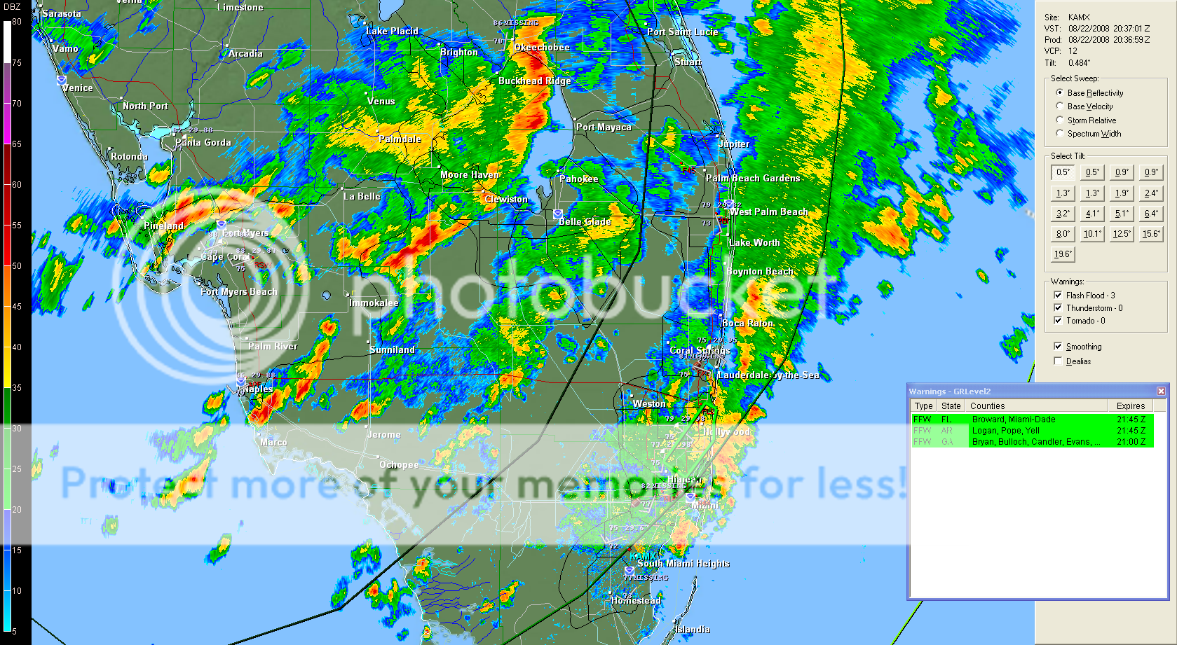
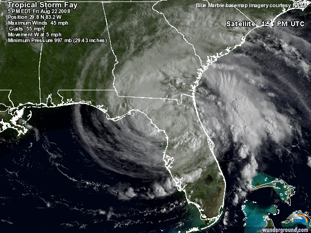
AT 500 PM EDT...2100Z...THE CENTER OF TROPICAL STORM FAY WAS LOCATED
NEAR LATITUDE 29.8 NORTH...LONGITUDE 83.2 WEST OR ABOUT 50 MILES...
80 KM...NORTH OF CEDAR KEY FLORIDA AND ABOUT 110 MILES...175 KM...
EAST OF APALACHICOLA FLORIDA.
About over Hines according to the 5PM position.
http://www.wunderground.com/wundermap/? ... 00&zoom=10
NEAR LATITUDE 29.8 NORTH...LONGITUDE 83.2 WEST OR ABOUT 50 MILES...
80 KM...NORTH OF CEDAR KEY FLORIDA AND ABOUT 110 MILES...175 KM...
EAST OF APALACHICOLA FLORIDA.
About over Hines according to the 5PM position.
http://www.wunderground.com/wundermap/? ... 00&zoom=10
0 likes
-
sittingduck

- S2K Supporter
- Posts: 112
- Joined: Mon Aug 13, 2007 3:16 pm
- Location: venice florida


-
Ed Mahmoud
Re: ATL: Tropical Storm Fay over northern Florida Penninsula
wmk7479 wrote:Yeah "only a tropical storm" meanwhile, here in Tally a friend just had a tree fall on the house... and we've hardly felt the storm... a couple of heavy rains and a few minor gusts.
And to think I have people that laugh at me that say I'd bail out of Tally if I knew 100mph sustained would be in town. The trees here would go flying everywhere, and the houses are built like match sticks... not the concrete block of south fla or the poured concrete.
I just hope it never happens.
When you get so much rain the dirt basically becomes mud, doesn't take all that much wind to topple a tree, especially one with shallow roots. Willow trees are practically famous for uprooting in relatively light winds following heavy rain.
0 likes
-
tolakram
- Admin

- Posts: 20179
- Age: 62
- Joined: Sun Aug 27, 2006 8:23 pm
- Location: Florence, KY (name is Mark)
Re: ATL: Tropical Storm Fay over northern Florida Penninsula
AT 500 PM EDT...2100Z...THE CENTER OF TROPICAL STORM FAY WAS LOCATED
NEAR LATITUDE 29.8 NORTH...LONGITUDE 83.2 WEST OR ABOUT 50 MILES...
80 KM...NORTH OF CEDAR KEY FLORIDA AND ABOUT 110 MILES...175 KM...
EAST OF APALACHICOLA FLORIDA.

By the way you can turn on hurricane tracks and forecasts on that wundermap and then recreate the link.
http://www.wunderground.com/wundermap/? ... re=0&tor=0
NEAR LATITUDE 29.8 NORTH...LONGITUDE 83.2 WEST OR ABOUT 50 MILES...
80 KM...NORTH OF CEDAR KEY FLORIDA AND ABOUT 110 MILES...175 KM...
EAST OF APALACHICOLA FLORIDA.
By the way you can turn on hurricane tracks and forecasts on that wundermap and then recreate the link.
http://www.wunderground.com/wundermap/? ... re=0&tor=0
0 likes
Re: ATL: Tropical Storm Fay over northern Florida Penninsula
tolakram wrote:By the way you can turn on hurricane tracks and forecasts on that wundermap and then recreate the link.
http://www.wunderground.com/wundermap/? ... re=0&tor=0
Much better thank you.
0 likes
Who is online
Users browsing this forum: No registered users and 15 guests