ATL GUSTAV: Tropical Depression - Discussion

Moderator: S2k Moderators

Message
Author
jaxfladude
Category 5
Category 5
Posts: 1249
Joined: Wed Aug 24, 2005 9:36 pm
Location: Jacksonville, Fla

Re: ATL: Invest 94L in Eastern Caribbean Sea

#941 Postby jaxfladude » Sun Aug 24, 2008 8:04 pm

CalmBeforeStorm wrote:
Sanibel wrote:
I really see a possible RI when this system gets a little further Northwest under Haiti , conditions seem favorable and the water temps ramp up over the nw carribean.


I would temper that since Fay transited the same waters without any intensification. 94L is also having trouble getting a center together so the same conditions could be at play.


Fay had just gone over the entire Dominican Republic and had little time to get it's structure back before going over Cuba and Florida. This system figures to have very little land interaction foir awhile.


Likely, if it does develop, to be bad news for a lot of people....
0 likes   

jlauderdal
S2K Supporter
S2K Supporter
Posts: 7183
Joined: Wed May 19, 2004 5:46 am
Location: NE Fort Lauderdale
Contact:

Re: ATL: Invest 94L in Eastern Caribbean Sea

#942 Postby jlauderdal » Sun Aug 24, 2008 8:05 pm

Derek Ortt wrote:
jlauderdal wrote:
wxman57 wrote:Well, perhaps we'll have a better idea of where it may form by tomorrow. Unfortunately, we have to issue 7-day tracks on such disturbances to our clients. I discussed with my on-duty forecaster the possibility of a forked track. One west, one turning north. ;-)


great, how about releasing that forked track for our reading pleasure


private forecasts costs a good deal of money :wink:


so a fork track is like two forecasts for the price of one i guess.. :D

kind of like a stockbroker saying well it might go up or might go down.. :D
0 likes   

Clipper96

#943 Postby Clipper96 » Sun Aug 24, 2008 8:06 pm

This storm is getting more organized by the hour. Below, it looks like a "fat-tailed #6"; this afternoon, it was all "tail", or a bean-shaped arc. Later tonight, the bulb of the 6 should fire a more symmetrical burst of convection while the top band dies down.

Image
0 likes   

User avatar
Tampa_God
Category 1
Category 1
Posts: 333
Age: 35
Joined: Wed May 31, 2006 7:27 pm
Location: New Port Richey/Trinity, FL

Re: ATL: Invest 94L in Eastern Caribbean Sea

#944 Postby Tampa_God » Sun Aug 24, 2008 8:10 pm

It certainly looks like this storm is trying to become more compact and trying to get convection all around it's center. At the moment, my guess is the direction is dead West. Possibly taking more of a WNW movement by tomorrow morning.
0 likes   

Dean4Storms
S2K Supporter
S2K Supporter
Posts: 6358
Age: 62
Joined: Sun Aug 31, 2003 1:01 pm
Location: Miramar Bch. FL

#945 Postby Dean4Storms » Sun Aug 24, 2008 8:13 pm

Well it is currently in the Zone of Death of the Carib. but once it gets west of 70W lookout.
0 likes   

User avatar
cycloneye
Admin
Admin
Posts: 145366
Age: 68
Joined: Thu Oct 10, 2002 10:54 am
Location: San Juan, Puerto Rico

Re: ATL: Invest 94L in Eastern Caribbean Sea

#946 Postby cycloneye » Sun Aug 24, 2008 8:13 pm

Image
0 likes   

User avatar
cycloneye
Admin
Admin
Posts: 145366
Age: 68
Joined: Thu Oct 10, 2002 10:54 am
Location: San Juan, Puerto Rico

Re: ATL: Invest 94L in Eastern Caribbean Sea

#947 Postby cycloneye » Sun Aug 24, 2008 8:14 pm

24/2345 UTC 13.7N 67.5W T1.5/1.5 94L -- Atlantic Ocean
0 likes   

Sanibel
Category 5
Category 5
Posts: 10375
Joined: Mon Aug 30, 2004 11:06 pm
Location: Offshore SW Florida

Re: ATL: Invest 94L in Eastern Caribbean Sea

#948 Postby Sanibel » Sun Aug 24, 2008 8:15 pm

Hang out. Take a closer look at Shortwave and that center could be more WNW and further N than you realize.
0 likes   

Clipper96

Re:

#949 Postby Clipper96 » Sun Aug 24, 2008 8:19 pm

(Per last frame, Cycloneye's fix is right on the money.)

Link for the loop of pic below: http://www.ssd.noaa.gov/goes/flt/t2/loop-ir2.html
Clipper96 wrote:This storm is getting more organized by the hour. Below, it looks like a "fat-tailed #6"; this afternoon, it was all "tail", or a bean-shaped arc. Later tonight, the bulb of the 6 should fire a more symmetrical burst of convection while the top band dies down.

Image
Last edited by Clipper96 on Sun Aug 24, 2008 8:21 pm, edited 1 time in total.
0 likes   

jaxfladude
Category 5
Category 5
Posts: 1249
Joined: Wed Aug 24, 2005 9:36 pm
Location: Jacksonville, Fla

Re: ATL: Invest 94L in Eastern Caribbean Sea

#950 Postby jaxfladude » Sun Aug 24, 2008 8:19 pm

:uarrow: :uarrow: :uarrow:
Red Alert in the next 24 hours?
0 likes   

User avatar
cycloneye
Admin
Admin
Posts: 145366
Age: 68
Joined: Thu Oct 10, 2002 10:54 am
Location: San Juan, Puerto Rico

Re: ATL: Invest 94L in Eastern Caribbean Sea

#951 Postby cycloneye » Sun Aug 24, 2008 8:24 pm

(Per last frame, Cycloneye's fix is right on the money.)


Just to clarify,that position is not mines but from SSD Dvorak. :)

http://www.ssd.noaa.gov/PS/TROP/positions.html
0 likes   

User avatar
SouthFLTropics
Category 5
Category 5
Posts: 4236
Age: 50
Joined: Thu Aug 14, 2003 8:04 am
Location: Port St. Lucie, Florida

Re: ATL: Invest 94L in Eastern Caribbean Sea

#952 Postby SouthFLTropics » Sun Aug 24, 2008 8:27 pm

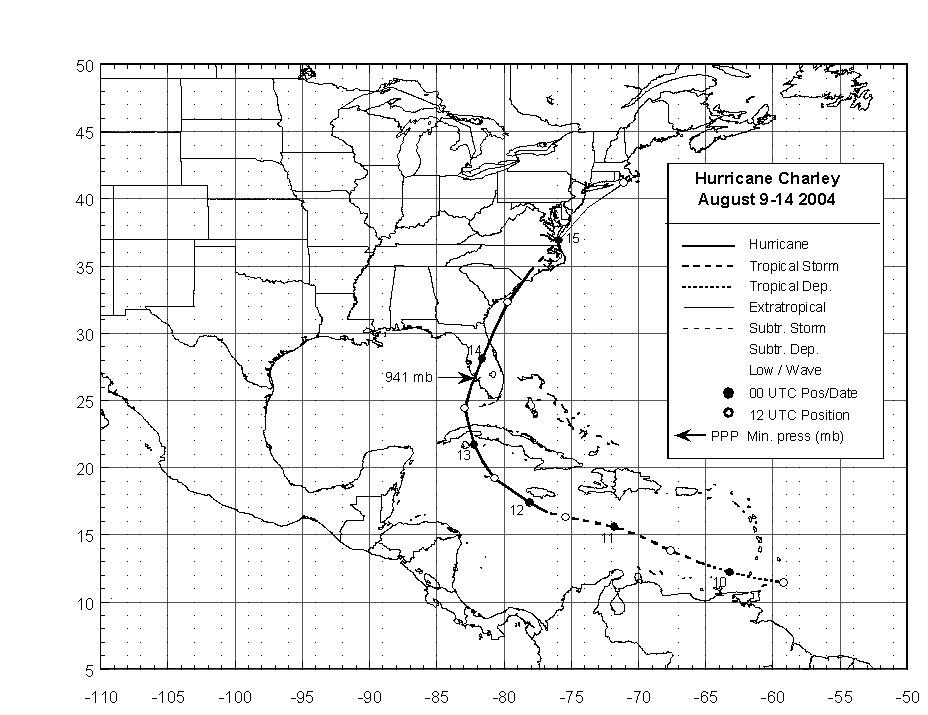
Image

As much as I hate making comparisons to previous storms I just cannot help but notice some same features on Charley's track shown above...By no means am I saying it is going to follow this track but with it forming in the same general area and SOME models showing the same general track, well it's worth looking at...

SFT
0 likes   

User avatar
AtlanticWind
S2K Supporter
S2K Supporter
Posts: 1890
Age: 66
Joined: Sun Aug 08, 2004 9:57 pm
Location: Plantation,Fla

Re: ATL: Invest 94L in Eastern Caribbean Sea

#953 Postby AtlanticWind » Sun Aug 24, 2008 8:28 pm

cycloneye wrote:
(Per last frame, Cycloneye's fix is right on the money.)


Just to clarify,that position is not mines but from SSD Dvorak. :)

http://www.ssd.noaa.gov/PS/TROP/positions.html

That position looks right to me
0 likes   

fasterdisaster
Category 5
Category 5
Posts: 1868
Joined: Mon Sep 19, 2005 4:41 pm
Location: Miami, Florida

#954 Postby fasterdisaster » Sun Aug 24, 2008 8:29 pm

I think it's too far south to follow Charley.
0 likes   

User avatar
wxman57
Moderator-Pro Met
Moderator-Pro Met
Posts: 22979
Age: 67
Joined: Sat Jun 21, 2003 8:06 pm
Location: Houston, TX (southwest)

Re:

#955 Postby wxman57 » Sun Aug 24, 2008 8:31 pm

Derek Ortt wrote:one thing we do need... as of 2100 UTC the low level convergence was not very good at all.

Remember that with Fay and Dolly (the last 94L)... we did not see development until the low level convergence became well-established


It's hard to get low-level convergence when the forward speed is so high. It'll have to slow down, first.
0 likes   

User avatar
TreasureIslandFLGal
S2K Supporter
S2K Supporter
Posts: 1581
Age: 57
Joined: Sun Aug 15, 2004 6:16 pm
Location: Clearwater, Florida ~3 miles from the coast now. We finally moved safely off the barrier island!

Re:

#956 Postby TreasureIslandFLGal » Sun Aug 24, 2008 8:36 pm

fasterdisaster wrote:I think it's too far south to follow Charley.


Where it is now is not where it will be in a few days. It will be in the same general vicinity that charley was. i doubt the same synoptic setup will be there again though. are we expecting another very deep diving front? if not, this shouldn't take any hard right turns. in fact, shouldn't it just follow the weakness left by Fay?
0 likes   

Derek Ortt

Re: ATL: Invest 94L in Eastern Caribbean Sea

#957 Postby Derek Ortt » Sun Aug 24, 2008 8:43 pm

Sanibel wrote:
Fay had just gone over the entire Dominican Republic and had little time to get it's structure back before going over Cuba and Florida. This system figures to have very little land interaction foir awhile.


Uncertain.

A good comparison would be Dean and Felix that tracked across the same area with much better organization by this point. Fay had plenty of prime waters to rebound and didn't. I expect hurricane from this if it stays overwater. Right outliers are busting right now.


Highly untrue, Sanibel

Fay did NOT have anything close to enough time over the water to rebound. it kept clipping land. When it was organizing south of Cuba, it went over land. It then went over Florida as it was about to undergo RI. Did not make it far enough off of Florida to RI on either coast
0 likes   

Sanibel
Category 5
Category 5
Posts: 10375
Joined: Mon Aug 30, 2004 11:06 pm
Location: Offshore SW Florida

Re: ATL: Invest 94L in Eastern Caribbean Sea

#958 Postby Sanibel » Sun Aug 24, 2008 8:43 pm

Could there be a ULL over it giving those false centers?


Highly untrue, Sanibel


While it did get some lagging disruption from Hispaniola it is my opinion that it had enough time to go stronger than the 60mph it entered Cuba at. I'm too lazy to do the research, but I suspect you could find similar tracks over those prime south of Cuba SST's where storms took the same time and did much better. A good example would be Fay's structure quirks near Key West. The environment was too hostile for potential peak intensity - which was the point to begin with. In fact I would even entertain doubts whether an overwater track would have done too much better.
Last edited by Sanibel on Sun Aug 24, 2008 8:51 pm, edited 2 times in total.
0 likes   

Ed Mahmoud

Re: ATL: Invest 94L in Eastern Caribbean Sea

#959 Postby Ed Mahmoud » Sun Aug 24, 2008 8:48 pm

JB's latest video says 95L, which is two waves merging, per JB, will deflect 94L more Northward than mean steering would indicate. JB sees possibly 3 threats to SE US, 94L, 95L and wave coming off Africa.
0 likes   

Derek Ortt

Re:

#960 Postby Derek Ortt » Sun Aug 24, 2008 8:48 pm

Dean4Storms wrote:Well it is currently in the Zone of Death of the Carib. but once it gets west of 70W lookout.


there is no zone of death in the Carib. A bad myth that ahs been dispelled many times in recent years
0 likes   


Return to “2008”

Who is online

Users browsing this forum: No registered users and 3 guests