ATL GUSTAV: Tropical Depression - Discussion
Moderator: S2k Moderators
-
deltadog03

- Professional-Met

- Posts: 3580
- Joined: Tue Jul 05, 2005 6:16 pm
- Location: Macon, GA
-
Cryomaniac
- Category 5

- Posts: 1289
- Joined: Tue Aug 15, 2006 2:26 pm
- Location: Newark, Nottinghamshire, UK
- Contact:
Re: Invest_RENUMBER_al942008_al072008.ren=TC at 11 am
Category 5 wrote:Sanibel wrote:Right to hurricane.
LOL, care to back that up?
Waiting for recon would be the sensible thing to do.
0 likes

-
dixiebreeze

- S2K Supporter

- Posts: 5140
- Joined: Wed Sep 03, 2003 5:07 pm
- Location: crystal river, fla.
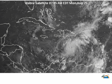
Re: ATL: Invest 94L=Tropical Cyclone at 11 am
DATE/TIME LAT LON CLASSIFICATION STORM
25/1145 UTC 15.1N 69.6W T2.5/2.5 94L -- Atlantic Ocean
25/1145 UTC 15.1N 69.6W T2.5/2.5 94L -- Atlantic Ocean
0 likes

Re: Re:
Stormcenter wrote:ROCK wrote:HURAKAN wrote:
dry spot, dry spot, dry spot
yeah, where is MATT? give me an eye roll.....that is an eye....
If this were a hurrricane already then it would have to be some sort of record and a big drop pass by the NHC....neither is likely.

SC.....never said it was a hurricane...just said it looked like an eye....based on the MV pass.
0 likes
Re: ATL: Invest 94L=Tropical Cyclone at 11 am
LOL, care to back that up?
I have to remember that people in here stay with the professional definition of storm status. So it will probably go through the official TS status before hurricane. But remember all the lectures about "only hurricanes have eyes" in here. You can't win. However the eye is telling you hurricane soon.
Last edited by Sanibel on Mon Aug 25, 2008 9:33 am, edited 2 times in total.
0 likes
-
Ed Mahmoud
Re: ATL: Invest 94L=Tropical Cyclone at 11 am
This should be an interesting recon mission this afternoon. Bad feeling for Florida about this one, especially after all the rain from Fay...
0 likes


-
lrak

- S2K Supporter
- Posts: 1770
- Age: 59
- Joined: Thu Jun 21, 2007 2:48 pm
- Location: Corpus Christi, TX
Re: ATL: Invest 94L=Tropical Cyclone at 11 am
WOW, didn't see this happening so soon.
Last edited by lrak on Mon Aug 25, 2008 9:33 am, edited 1 time in total.
0 likes
-
gatorcane

- S2K Supporter
- Posts: 23708
- Age: 48
- Joined: Sun Mar 13, 2005 3:54 pm
- Location: Boca Raton, FL
Re: ATL: Invest 94L=Tropical Cyclone at 11 am
Ed Mahmoud wrote:This should be an interesting recon mission this afternoon. Bad feeling for Florida about this one, especially after all the rain from Fay...
I would think South Florida will be in the cone at 11AM EST.....given the current steering patterns.
Media will latch on quick if this verifies.
0 likes
-
Cryomaniac
- Category 5
- Posts: 1289
- Joined: Tue Aug 15, 2006 2:26 pm
- Location: Newark, Nottinghamshire, UK
- Contact:
Re: ATL: Invest 94L=Tropical Cyclone at 11 am
Sanibel wrote: I have to remember that people in here stay with the professional definition of storm status. So it will probably go through the official TS status before hurricane. But remember all the lectures about "only hurricanes have eyes" in here. Your can't win. However the eye is telling you hurricane soon.
For some reason, this reminds me of the whole "it's not a TC unless the NHC say it is" discussion from 2006...
0 likes
Re: ATL: Invest 94L=Tropical Cyclone at 11 am
Any good microwave passes?
A few pages back with an obvious, well-defined eye.
0 likes
Re: ATL: Invest 94L=Tropical Cyclone at 11 am
JB says he believes it's already sub 1000mb and 50 kt
0 likes
-
Ed Mahmoud
Re: ATL: Invest 94L=Tropical Cyclone at 11 am
Sanibel wrote:Any good microwave passes?
A few pages back with an obvious, well-defined eye.
I believe the proper term, as used by NHC, when Fay was approaching Okeechobee, was "eye like feature".
It has a well defined 'eye like feature' surrounded by a ring of deep storms.
0 likes
-
micktooth

- S2K Supporter
- Posts: 391
- Joined: Mon Jul 11, 2005 3:47 pm
- Location: PreK:New Orleans,PostK:Colorado
Re: ATL: Invest 94L=Tropical Cyclone shortly
I can't help but think of that old classic song:
"You dropped a bomb on me, baby, you dropped a bomb on me..."
"You dropped a bomb on me, baby, you dropped a bomb on me..."
0 likes
Re: ATL: Invest 94L=Tropical Cyclone shortly
At this juncture I think this is calling for figuring out if this right tendency will continue and go east of Florida?
0 likes
-
Ed Mahmoud
Re: ATL: Invest 94L=Tropical Cyclone shortly
ZCZC MIATCDAT1 ALL
TTAA00 KNHC DDHHMM
TROPICAL STORM FAY DISCUSSION NUMBER 16
NWS TPC/NATIONAL HURRICANE CENTER MIAMI FL AL062008
1100 AM EDT TUE AUG 19 2008
DOPPLER RADAR DATA AND SATELLITE IMAGES REVEAL THAT FAY HAS KEPT A
WELL DEFINED PATTERN...AND IN FACT...RADAR SHOWS A RING OF
CONVECTION WHICH RESEMBLES AN EYE FEATURE.
ZCZC MIATCDAT1 ALL
TTAA00 KNHC DDHHMM
TROPICAL STORM FAY DISCUSSION NUMBER 17
NWS TPC/NATIONAL HURRICANE CENTER MIAMI FL AL062008
500 PM EDT TUE AUG 19 2008
FAY DID NOT WEAKEN OVER LAND AS ANTICIPATED AND IN FACT...IT IS
STRONGER THAN IT HAS EVER BEEN SO FAR. INITIAL INTENSITY IS
CONSERVATIVELY SET AT 55 KNOTS. THIS IS BASED ON SATELLITE...RADAR
AND CONFIRMED BY SURFACE OBSERVATIONS. THIS HAS PROMPTED A
SIGNIFICANT CHANGE IN THE INTENSITY FORECAST. GIVEN THAT FAY HAS
KEPT SUCH A WELL-DEFINED SIGNATURE ON RADAR AND ON SATELLITE...THE
CHANCES THAT THE CYCLONE BECOMES A HURRICANE AS IT MOVES OVER
THE GULF STREAM EAST OF FLORIDA HAVE INCREASED. THE INTENSIFICATION
IS SUPPORTED BY SHIPS...THE GFDL AND THE HWRF MODELS...AND IS
REFLECTED IN THE OFFICIAL FORECAST.
THE EYE FEATURE ASSOCIATED WITH FAY HAS BEEN TRACKED BY SATELLITE
AND NWS DOPPLER RADAR AND THE BEST ESTIMATE OF THE INITIAL MOTION
IS NORTH-NORTHEAST OR 020 DEGREES AT 7 KNOTS.
The correct term is "eye feature".
0 likes
-
Comanche

- Category 1

- Posts: 381
- Age: 54
- Joined: Wed Jul 06, 2005 9:33 am
- Location: Clear Lake City Texas
Re: ATL: Invest 94L=Tropical Cyclone at 11 am
Kludge wrote:JB says he believes it's already sub 1000mb and 50 kt
And headed for New York Harbor??
0 likes
Who is online
Users browsing this forum: No registered users and 102 guests